Blog #21 Water and trees are scarce but there are plenty of geckos….
- Pamela Sonier
- 3 days ago
- 40 min read

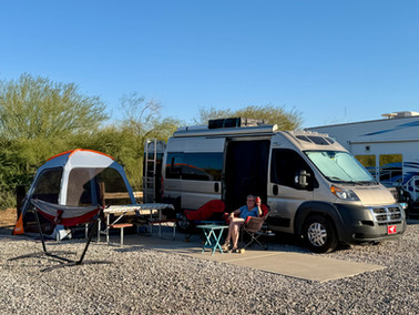
Up until now, since we began our two year road trip adventure, we did not stop for more than a few days in one place. This time though, we needed a good break and decided to stay for a whole month at the KOA campground in Yuma Arizona. This stay turned out to be quite a memorable and enjoyable one. The site we were in backed onto the West Wetlands of Yuma and we were greeted to the singing of birds every day, all day long. Mockingbirds galore with their amazing array of sounds, doves, wrens, verdins, roadrunners, woodpeckers, turkey vultures soaring in the distance, and so many more.


Birds galore!
We even had a local rooster who was hellbent on cock-a-doodle-doing all day long, starting from 3 o’clock in the mornings. We naively thought roosters only cock-a-doodle-do in the morning, not this guy. Plus, funny thing is, there was a covey of quails, of which the rooster decided he was their leader - or else the quails picked him as a leader - either way, they followed him almost everywhere. It was quite an interesting dynamic, and we became wonderfully accustomed to him and his quick-stepping followers. Trying to snap a picture was another story though, the rooster was elusive and mostly hid behind bushes. Every once in a rare while he would cross our site to venture onto the rest of the campground. So we did in the end manage to get a few good pictures. The quails on the other hand remained in or just at the edge of the bushes, and never ventured beyond the fence. These birds were quick on their little feet and the second we reached for our phones for a picture, they would scatter and be gone! We also had a couple small pet geckos who lived just behind us near the fence. They would zigzag along on the fence railing hunting for bugs, we guessed. It was all a bit of a zoo. And we loved it, we fitted right in….

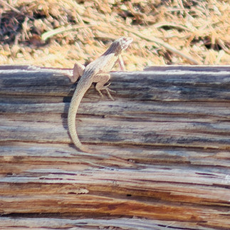


Yuma campground just a few members from the zoo….
Yuma is considered one of the sunniest places in the world averaging 320 days of sunlight each year, and it’s hot. During our stay, temperatures reached up to the high 30s, a little too hot for us Calgarians. Here the locals call it “warm”, after all it is their winter. By 10am the temperatures was already close to 30, and we would wait out the day hoping for a breeze so we could cool down a bit. We never imagined we would complain about heat this winter considering that last winter we were greeted with so much cold, rain, and shovelling snow in New-Orleans. But really we mostly enjoyed this heat. It was wonderful to wear shorts and sandals almost everyday. It was a little harder for Treme though, who panted the whole time. We tried as best we could to keep her cooled down with damp towels, a cooling mat, and the AC.


Getting through another hot day
Other than soaking up the heat and sunshine, while in Yuma, we did manage to see a few interesting sites. The McPhaul Suspension Bridge or “The Bridge to Nowhere”, as the locals now call it, was interesting. This bridge was built in 1929 prior to the Golden Gate Bridge and it is said to have been the structural inspiration, or prototype, for the Golden Gate Bridge. The successful construction of the McPhaul Suspension Bridge demonstrated that long-span suspension bridges could withstand harsh conditions. This in turn convinced state officials to proceed with the much larger Golden Gate Bridge. Joseph Strauss who lead the construction of the Golden Gate Bridge also oversaw the construction of this smaller bridge. The McPhaul bridge now stands in the desert, literally in the middle of nowhere crossing the Colorado river, and slowly deteriorating. It is now fenced and blocked to the public as it is not safe or stable for even pedestrian traffic. So we were not able to walk onto it but it was a fun side trip anyway.


The McPhaul Suspension Bridge
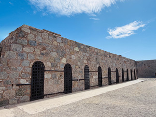
Probably the most famous tourist attraction in Yuma is the Yuma Territorial Prison State Park museum. This prison opened in 1876 and the first convict was William Hall who had committed murder in Tucson. The prison operated for 33 years and closed in 1909. Through its 33 years of operation there were over 3,000 men and women jailed here. Prisoners were here for multiple reasons from being Mormon, Mexican Revolutionaries, to selling liquor to Indians, and the regular crimes such as murder, forgery, assault, and plain old burglary.


Yuma Territorial Prison
Lizzie Gallagher was the first female prisoner in 1878, she was charged with manslaughter. At that time the prison was not yet set up for women so she spent 42 days in solitary confinement and then was pardoned and released. In 1889 Manuela Fimbres who was serving time for accessory to murder gave birth to a baby boy. The baby was allowed to stayed with her and after two years she was pardoned and released due to concerns for the child's wellbeing. Finally in 1893 a separate women’s ward was completed. During the prison’s operation, 29 women were jailed here stemming from adultery, seduction, and of course murder.


Women prisoners - Yuma State Prison
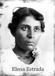
The prison museum is really well done and there are many intriguing stories. Elena Estrada was sentenced to 7 years for manslaughter; she stabbed her lover who had been unfaithful. After stabbing him she cut open his chest pulled out his heart and threw it in his face. Yikes! Pearl Hart (The Bandit Queen) was sentenced to 5 years for robbery. She was born in Ontario Canada but ended up in Arizona. In 1899 Pearl and Joe Boot robbed a stagecoach that went between Globe and Florence AZ for $421.00 - this is often considered to be “Arizona’s last stagecoach robbery”. It is said that Pearl after robbing the passengers, gave each back $1.00 so they could buy something to eat once they arrived in Florence. Joe Boot was sentenced to 30 years in the Yuma prison. In 1901 while driving a supply wagon for a work, Joe escaped by simply walking away never to be seen or heard from again. A man named McDonald who had been a school superintendent was in prison for forgery. Prison officials thought he had good credentials so they asked him to manage the prisoners earnings, which he did. After his release they discovered he had embezzled $130.00 of the prisoners’ money. These are just a few of the numerous stories here.


The Yuma prison, it is said, had more modern amenities than many homes in town. They had electricity, forced ventilation, bathrooms, 2 bathtubs, 3 showers, and a library with over 2,000 books. The cells we saw though, did not convey any kind of comfort, they felt and looked horribly uncomfortable. I don’t believe the comfort of the prisoners was high on the prison’s list. One creative way of making money to buy books for the library was to turn the prison, including prisoners, into a tourist attraction. Guided tours were actually offered to the public. Of the 112 convicts who died while in this prison, 104 were buried in the prison cemetery. The most common cause of death was tuberculosis.


Yuma Territorial Prison
After the prison closure in 1909, starting in 1910 up until 1914, the Yuma High School used the building as a school, after their school was destroyed by fire. The fun story is that in 1914 the Yuma High School Football Team defeated the Phoenix Union High School in a championship game. Angry fans started calling the team “Criminals” because they had been using the prison as their temporary school. The team took it all in stride and in 1917 officially adopted the name and to this day are still called the Yuma Criminals. They are sometimes referred to as “Crims” for short. Another use for the prison after it had closed was during the time of the Great Depression. Starting in 1932 people squatted here after losing their homes during the Great Depression until 1939 when they were evicted from here. In 1942 the guard tower was used for spotting in WWII. We had the opportunity to wonder through the cell blocks and enter a few of the cells. Many cells still had their original six-bed steel bunkbeds in place. The environment here, with the heat, the snakes, rats, scorpions, bats, and just the harshness of life must have been horrendous.


Yuma Territorial Prison
When we paid our entrance admission we were given a small red light flashlight to use in the “Dark Cell”. When Guy asked why the light, we were told we could flash this light to check the inside of the cell as it was pitch black in there. The bats living in the cell don’t mind the red light as much - easier on their eyes. We could takes pictures but with no flash. And sure enough as soon as we entered the Dark Cell, what does Guy spot hanging on the ceiling, none other than a bat! After looking at it for a while with the red light, the thing decided to fly towards us only to settle somewhere else on the ceiling. I ran straight out of the cell. But Guy, in his infinite wisdom, kept calling me to come back in so I could hold the red light while he tried to take a picture of the bat. That didn’t work well for neither him, me, the bat, nor the pictures.


Guy looking for bats in the Dark Cell
The Dark Cell and the Ball & Chain were the only documented forms of punishment that were used on the prisoners who were caught breaking the rules. In the Dark Cell the prisoners were locked inside an iron cage and chained to iron ring bolts mounted into the stone floor. This 5-foot high cage sat in the middle of a 15-foot by 15-foot chamber carved into the hillside. There could be up to 15 prisoners at one time chained in there. The prisoners were stripped to their underwear, they had no bedding or bathroom facilities, and were given bread and water only once a day. It is said that sometimes the guards, for their own distorted pleasure, would throw scorpions or snakes into the cell. Just pure darkness, isolation, and torture. When Guy and I entered this Dark Cell, we both had a powerful feeling of deep heaviness and sadness. The longest time spent in the dark cell for a prisoner was John Clay who spent 104 consecutive days. Not a Guinness Book of Records I would strive for.


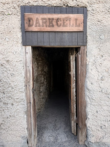
The Dark Cell and Punishment accessories
Not too far from Yuma is Felicity California. Felicity is now apparently recognized as the "Official Center of the World". This place has a unique outdoor museum that was created by Jacques-André Istel, a French-American entrepreneur and former paratrooper, and his wife Felicity for whom the town was named after. The outdoor museum, it is said, is designed to preserve human history for the next 4,000 years. At the entrance to the museum is a 21-foot granite pyramid which has a small plaque imbedded in the floor inside, officially marking “the center of the world”. The official designation of “The Center of the World”, does not come from any scientific studies or reasoning but from the children’s fantasy book called “Coe: The Good Dragon at the Center of the World” which Jacque-Andre had written and published in 1985. He used his book to convince the Imperial County Board of Supervisors that since no one could prove where the center of the world was, it might as well be in his town. So in May of 1985 the board unanimously voted to recognize Felicity California as the world’s “official” center. And, in 1989 the Institute Géographique National de France also officially recognized Felicity as the Center of the World.


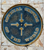


Felicity, Center of the World
Outside at the entrance of the museum stands the original 25 foot tall spiral section #12 of the Eiffel Tower’s staircase. This section was purchased by Istel in 1989 from an auction at the Chateau de Cheverny in France. Also at the museum entrance is a sundial sculpture officially known as “Michelangelo’s Arm of God Sundial”. The sundial’s gnomon (projecting piece) is a bronze sculpture modelled after the Arm of God from Michelangelo’s The Creation of Adam in the Sistine Chapel. The arm is precisely engineered to point through the granite pyramid toward the Chapel on the Hill which is the highest man-made point in the town. The sundial is accurate and is manually reset at noon every year on December 25.


Chapel on the Hill -Arm of God Sundial - section of the Eiffel Tower’s staircase
The museum encompasses approximately 700 large engraved Granite panels called "History of Humanity in Granite”. It is an overwhelming amount of information and facts to read and absorb. There is probably at least one week’s worth of intense reading here. Topics range from pretty much everything you can imagine like Evolution, Korean War, French Foreign Legion, American History, The Middle Ages, Oceans and Animals of the World, Science, Philosophy, Religion, Art, The Renaissance, Languages, even the history of Chocolate. These hand carved etchings are spectacular and amazingly well detailed - it is hard to believe that these have actually been carved freehand style in granite. There are still empty granite panels as this project is ongoing. We were told the etching artist would be returning in March to continue this amazing story of the history of mankind. The young girl working there was just a bundle of energy and we could really tell she loved her job. She took a few excellent photos of us while we were there - true Instagram shots!


Center of the World
The next place we visited while in Yuma was Los Algodones Mexico, which was only 18 km drive from our campsite. From what we were told from people, we could not quite comprehend this place until we actually arrived here and saw it with our own eyes. We parked on the American side of the border and walked across into Mexico. At the Mexican border, a young lady having a chat with her co-worker asked to see our passports as we nonchalantly walked by - it was that easy to enter Mexico. Most people go across to Los Algodones for dental, optical, beauty procedures, as well as to stock up on prescription drugs because the prices are a lot less. The town is known as “Molar City” for obvious reason; the streets are literally lined up with dental shops, optical shops, medical shops, pharmacies, and of course restaurants. Sidewalk hustlers continually try their best to draw tourists into their shops for procedures. Neither Guy nor I were brave enough to have any dental work done but we did decide on new prescription glasses. The amazing part is our glasses were complete and ready for pick up in 2 hours. It was easy and cheap. And so far they seem like good glasses. We walked along the streets soaking in the high energetic Mexican culture with lively music playing and vendors everywhere trying to sell us tourists something, anything. There were many people walking down the streets with frozen mouths and bandages hanging from the corner of their mouth trying to have legible conversations while still a bit dazed from the anaesthetic. I spoke with one guy from California who just had a root canal and with his crown the total cost was $300 usd! That is an amazing price. On the positive side, we ate some of the best Mexican food we have had to date at a small restaurant along the sidewalk. Overall it was a fun and intriguing experience. The only downfall was the almost 2 hour lineup, in the sun, to cross back into the US. The American border control was quite a bit more strict with whom they let in.


A day in Los Algodones Mexico
As previously mentioned this is the first time on our trip that we have stopped for an entire month. One thing this afforded us was to observe the lifestyle here at a “snowbird” campground. Some people live here year round, some get up and go to work every day, some have been coming here for years staying over the winter months and now at the beginning of March are slowly packing it in and heading north to get away from the Yuma extreme spring and summer heat when the temperatures can reach into the 40’s! We did have fun: we played Bingo and won, we got a bit of a tan, we napped in our hammock, we met some great and interesting people, we enjoyed many laughs and conversations, and Treme and I went for walks in the park every day. We could just sit outside in our chairs listening to the symphony of birds, enjoying the world around us, and saying hello to people passing by. It felt like a real neighbourhood. One night, on March 3rd, we got up to see the blood moon. It was amazing to see, and for the first time in my life I was able to
spot the Big Dipper on my own without Guy having to point it out to me. The evening sunsets and the open skies with a million stars so clear. We will miss this place. We did have a few mishaps though. One that I am not so proud of is of accidentally flushing a toothbrush down the toilet. But luckily, with Guy’s “McGyvering” skills, he was able to flush it out. And also unfortunate, Guy suffered another bout of diverticulitis. So we ended up having a nighttime visit to the ER. But all in all, we had lots of fun here in Yuma. In the end though, we both came to the realization that we do not do well “just sitting” and we both were itching to get back on the road.


Yuma Arizona
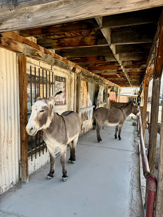
We had barely left Yuma and already our travelling itch was being scratched and feeling better. We were back on the road making our way to Oatman Arizona, a small ghost town that was once a mining town located along a portion of the iconic Route 66. Oatman holds two interesting stories for us, first one is the wild donkeys that roam freely around town. We decided to boondock just outside of town and already we were welcomed by a few of these local wild donkeys. There they were in the middle of the road, slowing traffic down, hoping to get a treat handed out. They, the “wild” donkeys, have the friendly tourists well figured out.


Boondocking just outside Oatman Az with our welcoming committee
Oatman started out as a camp in the mid-19th-century. Once gold was discovered in the early 20th-century the population grew to over 3,000 within a year. It became the largest gold producer in the American West for about ten years. After the gold rush, the people left, and the town died out. The donkeys that worked in the mines, were then released into the wild and became feral and wandered around the ghost town of Oatman and the surrounding areas. Years later a few people moved back to the small town and made it a bit of a tourist attraction with the star attraction being the wild donkeys roaming about the town - just hanging out being fed and petted by us gullible tourists. These donkeys are famous as they are the direct descendants of the pack animals used by gold miners in the early 1900s; and the residents of Oatman love them. Alfalfa cubes and hay pellets are sold in almost every store here - hence, the donkeys are very well fed. We didn’t see any young donkeys but apparently they have a small sticker or dot on their foreheads indicating they are still nursing and should not be fed. Interestingly, Oatman does have an honorary mayor named Walter who of course happens to be a donkey. Walter is also known as “Walter the Wonder Donkey”. He was appointed to be honorary mayor by the Oatman Chamber of Commerce in early 2020. He had been abandoned by his mother just hours after birth and was adopted and nursed back to health by local business owners Brad and Kelly Blake. Walter became a local celebrity and appears at town events and is considered a "good gray donkey". Another donkey here named Oliver is often considered the "sheriff" and he makes sure the town runs smoothly. We of course bought a bag of donkey food and fed the donkeys on the downtown streets. Its was definitely a fun stop along the way.


Historic Oatman Az and the wild donkeys
The second interesting story about Oatman is how the town got its name. The town was originally named "Vivian" and was renamed in 1909 after Olive Oatman. Olive was a young Illinois woman who along with her family were heading west to California when she and her family were attacked on February 18th 1851 by Apaches (although some officials say they were Yavapais). Her parents and four siblings were killed, her brother Lorenzo was left for dead and Olive who was 14 years old at the time, along with her younger sister Mary Ann, were abducted and held as slaves for a year, after which they were then sold to a Mojave chief. Their chins were tattooed blue with five vertical lines from the lip to the chin with small triangles. In the Mohave culture these facial tattoos are believed a necessity as without these tattoos ancestors would not recognize a person in Sil'aid (the land of the dead), and would be denied entry. These tattoos are also considered a symbol of protection for the soul and getting these meant that both Olive and her sister Mary Ann were no longer just captives but adopted members of the Mohave clan. Unfortunately Mary Ann died at the age of 11 years old from starvation in 1855 during a severe drought. Olive continued to live with this Mohave clan and in the winter of 1855-1856 on the persistence of her brother Lorenzo, the army finally located her and began negotiations for her freedom. On February 28, 1856, Olive wearing a bark skirt and only able to speak a few words of English was traded for a couple horse blankets and beds at Fort Yuma where she was reunited with her brother Lorenzo.


Olive Oatman with her facial tattoo
After her return to “white society” Olive became a lecturer. In November of 1865 she married John Brant Fairchild who was a successful cattle rancher and banker. They adopted a daughter and lived a quiet life in Michigan and eventually Texas. Author Royal Stratton wrote an exaggerated biography of Olive and her sister Mary Ann called “Captivity of the Oatman Girls” claiming that her blue chin tattoo marked her as a slave which was not true. The Mohave did not tattoo slaves because they did not care if they reached the afterlife. Olive had expressed deep love and gratitude for the Mohave families who had adopted her. And there is also historical evidence that confirms that this Mohave tradition of facial tattoos would have been a sign of her full integration into the tribe. It is said that her husband John was very protective of Olive’s past and that he had bought and burned as many copies of the Stratton book he could find. Olive often wore a veil in public to cover her “famous” blue chin tattoo. She lived in Sherman Texas until her death at the age of 65 on March 20, 1903. Athough the actual Oatman family massacre of 1851 did not happen in Oatman AZ, but 200 miles away from the town, Oatman was named in honor of the family and to honor Olive on her courage and tenacity of life.
After Oatman, in the matter of one day and 300 kms we travelled in three states and two time zones, including the lovely “Spring Forward” time change. No wonder we at times feel a bit confused as to where we are and what the time really is.


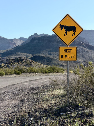

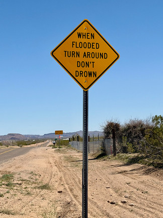
A few of the highway signs along the way
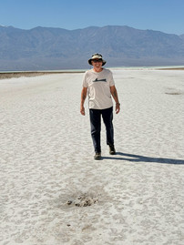
Death Valley got its name from a group of gold rush pioneers looking for a short cut to the California gold fields. They entered the valley during the winter of 1849-1850 where they became stranded for a few weeks. They suffered from thirst and hunger but only one person in the party died. Once they crossed the Panamint Mountains they looked back and one of the survivors said "Goodbye, Death Valley" and the name stuck. We, for our part, stayed here with what we must say is a bit more luxury then these pioneers had had. We had our Roadtrek, food, and water. Death Valley, we feel, is not always representative of its name. This place is really full of life everywhere; only just a bit of a different form of life. The valley is filled with unique rock formations, colourful mountains, and white arid salt flats.


Death Valley
Plus, this year, we happened to be here at the right time for what is a rare occurrence called the “Super Bloom”. Needless to say that at the time we were there, the valley was full of bloom-seeking-fanatic-tourists. People stopped everywhere and anywhere with zoom cameras galore. The “Super Bloom” is caused by a high amount of fall and winter rainfall. There are vibrant yellow flowers, purple Notch-leaf Phacelia, and Brown-eyed Primrose just to name a few. We could see the colours drape the hillsides. What we found interesting is that as we approached, the flowers were not crowded together in clusters. Each flower seemed to be growing in its own respected space. They were actually quite spread out. Between the flowers, the salt plains, and the hills and mountains surrounding us, we felt as if we were in another world. The rocks have been smoothed by years of erosion and the intense sunlight enhanced their continual movements.


We boondocked at a quiet site just outside the park. Quiet with the exception of the relentless wind. Plus, when the sun went down in the evening it turned to very cold. We drove into the park each morning to explore. Our first stop was up to Dante’s View, 5475 feet above sea level, on the ridge of the Black Mountains for panoramic views of the valley and Badwater Basin below. It was spectacular but it was extremely windy and cold, we even had to put on our winter coats so we could enjoy the view and hope we were not blown over the edge. Awesome sceneries with the valley below and high mountains with snow covered tops just across.


Dante’s View
Badwater Basin is the lowest point in North America at 282 feet below sea level. Amazingly, from this low point, we could look up at Telescope Peak which stood over 11,000 feet above us just on the other side of the flats. Experiencing both the lowest and the highest points in Death Valley at the exact same moment was, need we say, a bit surreal.


Badwater Basin
After visiting and walking on the Badwater Basin, we took a side trip down a bumpy dirt road to see what is known as the Devils Golf Course. The name came from a 1934 National Park Service guidebook which jokingly describe this place as where "only the devil could play golf". The surface is of halite salt crystals that were deposited by an ancient lake and sculpted over thousands of years by wind and rain. Below this surface is a layer of salt and gravel that is estimated to be between 1,000 and 9,000 feet deep. As we walked along on the salt, we discovered an open hole where very salty water reached the surface. The hole, approximately 8 feet in diameter, from where we stood, looked deep as we could not see its bottom, only darkness. We dared come close to its edge, but not too close for the fear of salt collapse. Walking on the salt almost felt like we were walking on a frozen lake, a very rough solid lake. The edge of the water hole made us feel like the salt was beginning to melt so we did not stay too long. It felt eerie.


The Devils Golf Course
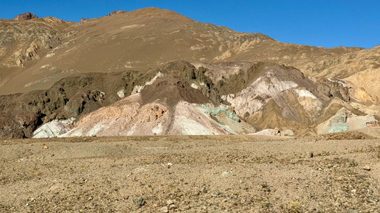
The Artist Palette is a beautiful one way twisted scenic drive that took us through hills with shades of pink, green, purple, and yellow. These colour variations are caused by the oxidation of volcanic deposits. The colours are a bright contrast to the more monochromatic environment we had been seeing in the deserts.


Scenic Artist Palette drive
Many prospectors came to Death Valley in search of gold and silver, which were rare. But borax, as it turned out, was “The White Gold of the Desert” and became Death Valleys most profitable mineral. The Harmony Borax was a mining site that operated in Death Valley from 1883 to 1888. The closing of the mine in 1888 was due to borax discoveries in lesser
harsh parts of California. The Harmony Borax mining site was also famous for being the birthplace of the 20 mule teams. These mule teams became the symbol of the borax industry. They hauled the refined mineral 165 miles across the desert to the nearest railroad. The loads weighed up to 36 tons which also included 1200 gallons of drinking water. The rear wagon wheels were 7 feet high and the entire unit including the mules was more than 100 feet long.


Harmony Borax mining site and the famous 20 mule team
Death Valley has five major sand dune fields that cover less than one percent of the park’s floor. We stopped at the most famous of these, the Mesquite Flat Sand Dunes. Some of the dunes here are almost 100 feet tall. We walked along in the sand but it was not easy with the intense heat from the sun reflecting on the sand. And although the dunes looked solid to walk on, our feet kept sinking into the sand. Along the way Guy spotted a fairly large gecko near a low bush so it was fun watching it stroll around back and forth.


Mesquite Flat Sand Dunes
Our last stop in Death Valley was a beautiful long drive down a very scenic and winding paved road toward the Wildrose Charcoal Kilns. That is, until we turned off onto a 13 kms of very bumpy and dusty dirt road. But what we saw at the end of this road was well worth all the humps and bumps and dust. In 1875, lead ore was discovered in the Argus Range. Not long after this discovery, George Hearst (father of William Randolph Hearst) purchased the land and formed the Modoc Consolidated Mining Company to mine the ore for silver. Soon, the company had depleted most of the area’s supply of wood used for smelting the ore. So Hearst ordered the construction of ten kilns to make charcoal from pine logs 25 miles from the mine in a more wooded area. The ten 25 foot high limestone kilns were completed in 1877. After only two years of operation, the mines were already shutting down due to the exhaustion of silver veins in the hills, and the kilns as a result were left abandoned. Because the kilns were not used for very long, they still stand in excellent condition. It was a real treat being able to explore these inside and out. In some of them we could still smell the odour of creosote.


Scenery on our way to the Wildrose Charcoal Kilns


Wildrose Charcoal Kilns
Not too far outside of Death Valley is Rhyolite Ghost Town. This town was once one of Nevada's largest cities during a gold rush boom from 1905 to 1910. The buildings that are still here are quite amazing in their structure and precision of built, and each has its own interesting history and stories. The Cook Bank Building was built in 1908 and was one of four banks. This was by far the most extravagant bank in the town at the time. It stood three stories tall and had Italian marble floors and staircases, mahogany woodwork accents, as well as electric lights and indoor plumbing. From what now remains of the building, we could only imagine how it must have been in its glory.


The Cook Bank Building
Tom Kelly’s Bottle House was built in 1906. Tom was an Australian born stonemason who became a gold miner. Because wood was so scarce in the area Tom paid the local children 10 cents for a wheelbarrow full of bottles and used these to build his house. For the construction he used over 50,000 beer and liquor bottles. Over and above this he did spend $2,500 for wood trim and fixtures. Interestingly, Kelly never actually lived in this house. Rather, he decided to auction it off. He sold 400 tickets at $5 each - in this deal he lost about $500. The Bennett family won the raffle and lived in the house from 1906 to 1914. And they added on a porch and a false chimney.


Tom Kelly’s Bottle House
The Rhyolite School also comes with an interesting story. This was the second school house here. The first was a small wooden building that opened in February 1906 with 26 students. One month later there were 46, and by October there were 74 students, and only one teacher. Within a year of its opening there were 225 more students enrolled. At this point, it became apparent there was a need for a bigger school so in September of 1907 a $20,000 bond was passed by voters and the Rhyolite School was built. The new school opened in January of 1909 and closed within two years in 1911 due to the declining mining industry and families began moving away. Interestingly, the original $20,000 bond that had been taken out in 1907 was not completely paid off until 1978. Bureaucracy sometimes moves very slowly.


Rhyolite Schoolhouse
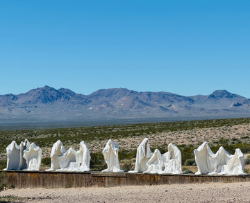
Just down the hill from Rhyolite is the Goldwell Open Air Museum which was created by a group of Belgian artists including the late Albert Szukalski. This is an 8-acre site that features large offbeat sculptures designed to interact with the surrounding desert landscape. We were most interested to see Albert Szukalski’s Last Supper that he created here in 1984. These are 12 stark white cloak figures that appear to be floating. There are no faces, no human figure details just the while cloaks which creates an almost eerie and surreal feeling. This piece did not disappoint.


Goldwell Open Air Museum
Viva Las Vegas! Here we are in Las Vegas but definitely not the Las Vegas of before. Las Vegas now seems more busy, more restricted, and very expensive. Plus trying to walk along the strip proved to be nearly impossible. The strip has changed and there are continual up and down stairways and escalators which lead to walkways, which continually led us into detours away from the sidewalk and into either stores or casinos, only to have us trying to find our way back to the strip - a business strategy we guessed so we would spend more time in stores and casinos. This definitely made it difficult to get anywhere fast. What we did see of the strip was very busy, crowded, and there seems to be a continual lineup to get anywhere, not to mention the construction sites. On the more positive side Guy hit the BIG Jackpot and I won a smaller jackpot. Also on the very positive side, I went to The Sphere to see The Wizard of Oz show - what an amazing venue the Sphere is. Plus, closer to my heart, that day would have been my mom’s 90th birthday. Momsie loved Judy Garland and I think she would have loved seeing this show. While watching the show I got soaked with soap sud bubbles falling down from above to imitate snow flakes, and leaves were also falling down during the tornado. With the vibrations of thunder and lights flashing as lightening, it was a real immersion experience. I was in the top level so three long escalator rides to the top and getting to my seat was a bit tricky as it is incredibly steep but what an amazing experience.


Viva Las Vegas!


The Sphere venue and the Wizard of Oz
And now it’s bye bye Las Vegas! We are happily leaving with a little bigger bank balance. Just a short way out of town we did a quick stop to see the mighty Hoover Dam. We had seen it years ago when the bypass bridge was still under construction. As during the 9/11 era, there is still now a strict security presence before crossing the dam. And we were absolutely surprised that the water level had dropped so much. Along the banks we could see the original water lines. It is said that since the original dam filling, the water has dropped 140 feet due to consistent droughts. We drove slowly across the dam, took a few beautiful pictures, and continued our way down the road.


Hoover Dam
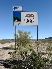
We soon embarked back on the famous Route 66 to make our way to Peach Springs AZ to visit the Grand Canyon Caverns. Along our way, in Kingman we visited the Arizona Route 66 Museum. This museum is filled with history and stories of the array of people who have travelled this iconic highway. Route 66, also named the “Mother Road”, stretches 2448 miles from east to west of the USA. Established in 1926, it was for a long time a vital artery connecting rural communities. It was decommissioned in 1985 but still remains an iconic road trip destination for many travellers. At the museum we saw a display of stunning black and white photography of the Dust Bowl Refugees. During the 1930s, Kingman was an important stop and temporary settlement for them. These migrants were a combination of families and people, mostly farmers totalling almost 210,000 who were fleeing the Great Plains Dust Bowl agricultural disaster of the 1930’s. They traveled west along Route 66 towards California in search of a better life. Kingman was their last major stop before the treacherous crossing of the Mojave Desert.


Arizona Route 66 Museum


Dust Bowl Refugees
Another very interesting story was the 1928 foot race called the International Transcontinental Footrace also known as the “Bunion Derby”. This race was the grand idea of Charles C. Pyle who is considered to be the first American sports promoter and athletic sports agent. In order to attract runners to the race the winner would receive a $25,000 prize. That was a lot of money in 1928. The race began on March 4, 1928 and was a total of 3423 miles from Los Angeles to New York City with the route mostly following the then new Route 66 to Chicago and then headed east to New York City. Vehicles followed the racers along the route for support and the runners slept in tents each night. There was a mobile shoe repair shop that kept everyone's footwear in top condition, and each night a carnival was held at the hosting towns. Sadly, the organizers underestimated the conditions of the Mojave Desert and dozens of runners dropped out after suffering heat exhaustion. Cars stalled, tires blew, and water supplies soon became scarce. Some of the racers suffered injuries because of the rough road conditions. One racer was struck by a car while another was hit by a motorcycle. The race that began with 199 male runners finished 84 days later in Madison Square Garden in New York City with only 55 runners completing the entire race. Despite all the public interest in the race Charles Pyle did not make any money, in fact he lost an estimated $150,000. Charles business model had been based on sponsorship fees from towns that often defaulted. As well, there were high operational costs and the large crowds who came to watch the race did so for free. Fellow promoter Tex Rickard ended up paying the prize money on behalf of Charles to Andy Payne a 22 year old member of the Cherokee Tribe from Oklahoma who had won the race with a time of 573 hours, 4 minutes, and 34 seconds.
Interestingly, Charles did try the Bunion Derby again in 1929 this time in reverse starting in New York City to Los Angeles. It, also turned out to be a financial failure. The 1929 race only had 77 men with 43 of them having raced in the previous 1928 race. Johnny Salo of Passaic New Jersey who had finished second in the 1928 race won the 1929 race. Pyle was unable to pay the promised prize money this time. After the race, Pyle soon filed for bankruptcy. Andy Payne who had won the 1928 race did not compete in the 1929 race but assisted as a "chief patrolman". Just another chapter of the amazing history of Route 66.


Racing in the Bunion Derby
Peach Springs, also along Route 66, is the administrative headquarters and capital for the Hualapai Indian Reservation. We stopped here to visit a 345-million-year-old cave known as the Grand Canyon Caverns. These caverns are a historic network of limestone caves and are considered to be the largest dry cavern system in the United States. Dry cavern means these caverns have little to no active water flow and are often considered "dead," meaning their rock formations are no longer growing or changing. Our entry fee included a one hour guided tour of the cavern and a reservations for lunch of delicious Bison burgers deep in the cave 200 feet below ground level at the restaurant called Caverns Grotto.


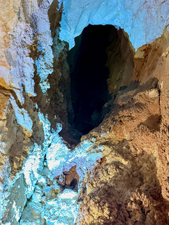


Deep inside the cave


Enjoying lunch 0ver 200 feet below ground
These caverns were discovered back in 1927 by Walter Peck a woodcutter for the Santa Fe Railroad who was on his way to a poker game when he nearly fell into a deep hole. He returned with a few friends and some ropes to explore the site. He thought that the iron oxide and selenite crystals he saw were gold and diamonds so he bought the surrounding 800 acres believing he had struck it rich. Well that did not work out as the minerals were basically worthless. So together with his brother Miles they went into the tourist business and started charging visitors 25 cents to be lowered 150 feet into the cave using a simple rope-and-winch system. Walter owned the caverns until the 1930s. From the 1940s to the 1970s the caverns were developed into a major Route 66 attraction under various owners. Between the 2000s to 2021 they were owned by John McEnulty who added the famous Caverns Suite in 2010. The suite was a rustic 1700 square foot hotel room located 220 feet underground. There were two queen beds, a kitchenette, dining area, and a bathroom (with limited flushes) at a cost of $1000 per night. Our guide told us that Ozzy Osborne and his son Jack stayed here one night. The suite and furnishings are still here but since the Havasupai Tribe purchased the caverns in 2022 they closed the suite as they discovered that unsupervised overnight access was found to negatively affect the delicate mineral formations in the caves. As well as the Caverns Suite, there is also a small and still operational wedding chapel down here.


Original entrance into the cave


Caverns Suite and Wedding Chapel
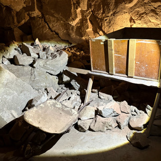
At one point along the caves we came into a large opening where a huge amount of survival rations were being stored. The caves, according to our guide, were a strategic plan by the US government for use as a designated fallout shelter during the 1962 Cuban Missile Crisis. We were told that there are enough rations stored here for 2,000 people for 2 weeks including barrels full of water. Funny thing about the water barrels is that they were also designed so that when empty could be used as resealable toilets. Also funny is a large part of the emergency food supplies were just boxes of crackers. We were told that crackers were the only source of food found here. There were of course medical supplies and other knickknacks. In the year 2000, added to these supplies was tons of fresh water bottles, as the caves were again to be used in the event of the possible Y2K computer grids crashes, which of course never happened. Meanwhile, these supplies remain in storage 200 feet below ground - perhaps for the next possible coming disaster.


Survival supplies
We continued traveling along Route 66 stopping at a few more small towns some of which are now desolate, some are forgotten, and some still somehow thriving. In Seligman we just had to stop at Delgadillo’s Snow Cap Drive-in. It is said they have the best milkshakes and ice cream so of course we had to stop to find out, and we must say we think this to be true.
Juan Delgadillo opened this drive-in starting in 1953 until his death in 2004. He had a quirky, hospitable, and fun loving personality famously making people laugh with his jokes. For example, the entry and exit doors have two door knobs, one on each side of the doors. The one on the hinges side is obviously fake but still it made us pause before we entered. His family have now taken over the business and they are as entertaining as he was. Guy ordered a milkshake and when the lady handed him his shake she had a mustard container in her hand and asked if he wanted mustard with his shake. She squeezed the container and what looked like a string of mustard squirted out. Of course it was only a yellow string that looked exactly like mustard. It certainly made us both jump and of course laugh along with everyone else in the line-up. One lady ordered a root-beer and two milkshakes. The lady behind the counter brought the order and said “here’s your root-beer and two shakes” and she shook the root-beer twice; she then put the two shakes on the counter. Fun stuff along the way….


Fun stops along Route 66


Delgadillo’s Snow Cap Drive-In
We have spent the last few months in the desert heat and barren landscape which in itself has its own form a beauty - a beauty which we slowly became accustomed to and appreciated. We boondocked just outside the Grand Canyon National Park, what a great spot only a 10 minute drive to the park. There were trees there. The feeling of seeing, touching, and breathing in this green atmosphere felt like a warm hug from home. Oh how we have missed this green environment.


Boondocking near Grand Canyon surrounded by trees
After our first quiet night here we woke up early so we could catch the sunrise in the park at Mather Point. A crowd of people had already formed for the sight but we managed to squeeze our way in. The views were stunning and we watched the sun as it slowly peeked its way out into a new day. Surprisingly with so many people around us it still felt peaceful and serene. We stayed here for about an hour soaking up the sunlight and watching the canyon’s sceneries come to life.


Beautiful sunrise at the Grand Canyon
After that we went for a walk with Treme along the South Rim trail making many stops to take in the magnificent views, so powerful. The beauty and the stillness of the canyon looked like a landscape painting. Treme loved this walk. Along the way we stopped to observe sap seeping out of trees where the branches had been trimmed. The perfectly clear sap, with the sun shining through, looked like sparkling crystal gems, necklace-like formations hanging from branches. We just kept seeing more and more beauty.


Grand Canyon in all its glory


Nature’s jewelry
From there we drove the Desert View Drive which is a scenic route with many pullover stops like Grandview Point, Moran Point, and the Desert View Watchtower. This world around us never stops to amaze us and as Guy says “we see beauty everyday, everywhere, in everything”. And at the Grand Canyon, we were in beauty and sensory overload mode. We fear that when our trip is completed, it may be difficult for us to not see and feel this abundance of daily stimuli.


More Grand Canyon beauty


It certainly is a small world. Surprise meet up in the Grand Canyon with friends we had met in Yuma Az - Jim, Laura, and Jiggles from Newfoundland
So here we go again with yet another “smelly” Roadtrek story. For a few days I had been noticing a faint almost indescribable odour. Our previous Blog smell story was about a decomposing hitchhiker mouse. This smell though was different, not as rank. What I was smelling was similar to rotting fruit. Now we still had a bunch of oranges from our pickings in Tucson. Guy said “I don't smell anything and there’s no way an orange could possibly have fallen behind the drawer where we keep them. The space over the drawer is just not large enough for an orange.” But as the good husband that Guy is he wanted to appease me so we took everything out and removed the drawer. Guy grabs a flashlight looks behind inside the cramped little space, and lo and behold he pulls out a very decomposed dried up and almost petrified banana. An orange couldn’t have made it through that opening but a banana sure could. All we could do was laugh….
March 16 was Guy’s birthday, celebrating the first day of his 71 years of life. He received a few family phone calls with birthday wishes. Being on the road, we sometimes feel so far away so it was a nice connection and added happiness to his special day. I sweetened him up with a bunch of candies and his one candle birthday cake was a free Cracker Barrel chocolate birthday cake. It was a good day.


HAPPY BIRTHDAY GUY!
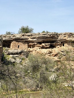
Out of the Grand Canyon, our first stop was the Montezuma Castle National Monument. This is a well preserved 20-room, five story, 800 year old Sinagua cliff dwelling 90 feet above ground carved into a limestone cliff. It is believed that several families lived here and a series of ladders were used to reach different levels of the dwelling. The name comes from early European settlers who mistakenly thought is was built by Aztec refugees, but this place has zero connection to the Aztec emperor Montezuma. Unfortunately since 1951 people are no longer allowed to climb up and explore the dwelling due to the damage previously caused to the structure, plus safety for visitors. Since the guided tours to the dwelling were stopped in 1951, a diorama of the inside was created to show people an up-close peek into what the dwelling may have looked like inside. We walk along a short trail and we were able to get fairly close views of the dwelling from 90 feet below. This really is quite a site to see with the backdrop of the cliffs. The exact reason for the abandonment of this place is still unknown. One theory is that of “soil nutrient depletion” which was caused from many years of gardening. It is believed that the grounds may have become nutrient depleted, forcing the people to look for more fertile grounds.


Montezuma Castle National Monument


Diorama of inside of the cave dwelling
Approximately 11 miles away is the Montezuma Well. This is a massive 365 feet wide, 85 foot deep natural limestone sinkhole that was formed over 11,000 years ago. Because of its high arsenic and carbon dioxide levels no fish can live here but five species that are found nowhere else on earth. These are the diatom (a one celled plant), a unique species of predator leech, springtail, water scorpions, and spring-snails. Fed by underground springs, the well continuously flows with over 1.5 million gallons of water each day and the water temperature is constant at 23 degrees celsius year round. There is a 100 rock steps stairway to the bottom of the well which we were able to descend to explore the sinkhole near the water. Again another amazing site for us to see.


Montezuma Well
We have now started our drive down the very beautiful and scenic Red Rock Byway not too far from Sedona. The views are a sea of red in the desert, stunningly beautiful. But oh, so busy with tourists. Parking was almost impossible as we tried to stop and enjoy the views. In one parking lot, Guy had me get out of the van so I could absorb the sceneries and take pictures while he drove round and round the parking lot until I was done. Wow! We are just not used to this kind of crowd. We did manage to stop at Bell Rock which is approximately 4919 feet about sea level and at Courthouse Butte which is 5454 feet tall. These were both stunning sites to see with the red vibrant colours they emitted. We read that both of these buttes are considered to be very powerful Sedona vortexes. Actually all of Sedona is considered to be a vortex. There are apparently five vortex sites in the area where the energy is believed to be more concentrated and these are two of the five sites. Each vortex is apparently a natural point of moving energy conducive to healing, meditation, and self-exploration. It is said that each vortex have their own characteristic energy from feminine, masculine, to motivation. We guessed our timing for this visit was perfect as we needed positive energy to deal with the parking and crowded situation.


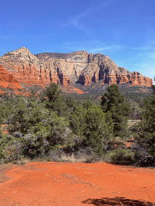


Scenic Red Rock Byway - Sedona
The next site to see was the Chapel of the Holy Cross, a Roman Catholic chapel. After navigating the traffic in the parking lot for a while, we turned around ready to leave, but got lucky and found parking near the bottom of the hill about half a kilometre away. We had a good walk up to the chapel. The Chapel of the Holy Cross is famously built directly into the red rock buttes of Sedona. The chapel was completed in 1956 and features a massive 90 foot tall iron cross that is both a structural element and a visual centrepiece. Once we got to the top and entered the church there was such a feeling of peace. Music was softly playing and it was a good place to take a break and reflect. Surprisingly, although the site was very crowded, the small church had plenty of seating. Perhaps the gods wanted us to sit in peace for a while.


Chapel of the Holy Cross
Just before arriving in Winslow we made a stop in Two Guns AZ, another abandoned ghost town along Route 66. There is not much left here except a few decaying brick buildings and an abandoned graffiti filled gas station, but the story is long and quite interesting.


Two Guns Arizona
Two Guns was originally known as Canyon Lodge and was a small trading post at the beginning of the 19th century. More people began to settle in the area and in 1922 when Earle and Louise Cundiff arrived they bought 320 acres of land and built a trading post, restaurant, gasoline station, and even a post office. They did this because by the early 1920s the road through town, known as the National Trail Highway - which would eventually become the Route 66 Highway - was the popular route across Diablo Canyon so Canyon Lodge became a busy stop for travellers. Harry “Two Guns” Miller a veteran of the Spanish-American War who was a bit eccentric, a bit unpleasant, and claimed to be a full-blooded Apache arrived in town wanting a piece of the action. He allegedly made a deal with Earle and Louise Cundiff to lease a business site for ten years. He eventually renamed the town Two Guns and it became a full blown tourist trap. Harry grew out his hair and braided it calling himself Chief of Crazy Thunder. He started a zoo with chicken-wire cages that held mountain lions and other local animals and started tours down into the Apache Death Cave which he had renamed the “Mystery Cave”.


Ruins of Two Guns Ghost-town
The cave itself is another interesting story. A group of Apache warriors allegedly raided a Navajo encampment killing almost everyone and kidnapping three young girls. Navajo scouts tracked the Apache raiders to the cave in the Diablo Canyon. It order to flush them out of the cave the Navajo built a massive sagebrush fire at the cave's entrance which trapped the warriors inside where they suffocated and burned to death. Some stories claim the Apache warriors used the blood of their horses to try to put out the flames. Harry wanted to expand on the story so he built fake ruins and made the tomb into a “cave dwelling”. He had saved the skulls of the Apaches from the tomb and sold them as souvenirs to tourist. He hung some electric lighting, made a soda stand, and renamed the death cave the Mystery Cave.


Apache Death Cave
It is around this time that “the curse” of the town Two Guns began. The curse started with a couple who had stayed in town for the night and ended up stealing a large amount of merchandise from the trading post which cost Harry quite a bit of money. Then on March 3, 1926 during an argument over their 10 year lease Harry had with Earle and Louise, Harry shot poor Earle dead. Somehow Harry was acquitted at the trial. Not long after the trial Harry was mauled by one of his mountian lions on two separate occasions and then he was bitten by a poisonous Gila monster which led to an illness that left his arm completely swollen. In 1929, a huge fire destroyed the trading post at Two Guns. Louise Cundiff tried to prove her claim on the homestead land but Harry protested stating that the land was his because he was there before them which of course was not true. Louise managed to keep ownership of the land and Harry soon departed town. Louise along with her second husband Phillip Herschel began to rebuild much of town on the opposite side of the canyon due to the Route 66 highway being rerouted which diverted the traffic away from the original site. They also built a Texaco Gas Station and by 1950 Louise and Phillip sold the town. Over the years the town changed hands and in the 1960s a man named Dreher began rebuilding the area with a restaurant, gift shop, gas station and he even had tourist trails to the cave. The new Interstate 40 was almost complete and Two Guns would have its own dedicated exit ramp, which meant tourists would be coming through the town again. All was going great until 1971 when a huge inferno destroyed the entire place. Since then there has been no more effort to rebuild and no one has lived here since. I guess the “curse” of Two Guns lives on.


The old road over the Diablo Canyon
And now it’s time for, “Well I'm a-standin' on the corner in Winslow, Arizona, with such a fine sight to see, it's a girl my lord, in a flatbed Ford, slowin' down to take a look at me….” Lyrics from the well know Eagles song “Take It Easy” from 1972. Jackson Brown co-wrote this song with Glenn Frey and the song was inspired by Jackson Brown who actually did break down on Route 66. He has stated that the girl in the “truck” happened in East Flagstaff but Glenn Frey added the “flatbed Ford” and changed it to Winslow Arizona as Flagstaff just didn’t have that musical flow. We have been wanting to see this corner for quite some time now. There is a Glenn Frey statue and road sign named Glenn Frey Drive. There is also a set of wings named Take It Easy, a statue with a guitar player, and of course the famous red flatbed Ford truck parked on the corner. It was fun. We were surprised at how small the town of Winslow is. For some reason we expected it to be larger but the population is only just under 9000. This is another of those towns along the famous Route 66 Highway that once the I-40 opened many of the businesses and people eventually left.


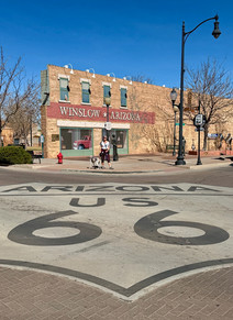


Just, Standin on the Corner
Also in Winslow, there is a 9-11 Remembrance Garden at which we stopped to visit. There are two metal beam fragments from the World Trade Center. While we were there a mother with her two young children were visiting. She told us they were doing a school project and they were learning about the September 11th attacks at school.


A other 9-11 memorial visit - Winslow AZ


Fun stop - Jack Rabbit Trading Post -Route 66
Our last stop in Arizona is the Petrified Forest National Park which includes a large portion of the Painted Desert. We drove through The Painted Desert first which is a beautiful colourful expanse of badlands covered in reds and pinks that are more than 200 million years old. The colours of this landscape come from the iron in the earth. There were a few places to stop along the way and absorb the beauty. The nice thing about this park is there are only two ways in and out. The road is 45 km long with a low speed limit and there is no entry or exit from the freeway so the traffic is not too busy.


Views of the stunning Painted Desert
After we traveled the Painted Desert we headed towards the Petrified Forest where a rusty 1932 Studebaker sits along the road where the Route 66 use to cut through the park. Interestingly the Petrified Forest is the only National Park in the United States where a portion of the Route 66 Highway cross through its boundaries.


Petrified Forest and the 1932 Studebaker
The Petrified Forest contains over 1000 archaeological sites and it is famous for its abundance of colourful petrified wood which are ancient trees from around 225 million years ago. These trees were buried by river sediment and volcanic ash cutting out the oxygen and preventing the decaying of the wood. Over millions of years the silica-rich groundwater replaced the organic wood with quartz crystals, creating these Petrified or "stone logs". We did a few of the scenic hikes here. The Giant Logs site was our first stop and it gave us the opportunity to see some of the largest and most colourful logs here.


The Giant Logs, some as much as four feet diameter
The Crystal Forest was our next stop. Here we could see beautiful crystals in the petrified logs when the sun shined on them. At this site there were many full size crystallized trees laying along the side of the path and there were so many that we actually felt as if we were virtually walking in an ancient forest.


The Crystal Forest
Our favorite trail was The Blue Mesa, what a beautiful 1.6 kms hike where we descended into a valley. From the valley floor we could actually look up and see petrified logs exposed from erosion sticking out of the side of the cliffs. There were many pieces of petrified logs at the bottom that had broken off and rolled down the cliffs. The beginning of the hike was quite steep down 115 feet and it sure got our heart rates going coming back up. But definitely well worth the effort. The hills were alive with bluish bentonite clay and dotted with petrified logs.


The Blue Mesa Trail
Further down the road we stopped to see Newspaper Rock which has more than 650 ancient native petroglyphs. These rocks are called newspaper because it is believed they were used by natives to communicate. The petrified Forest was definitely a shining highlight of our whole adventure.


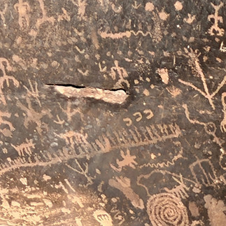
Newspaper Rock
Leaving Arizona and crossing into New Mexico. We have traveled through Arizona for a while now and have enjoyed every moment of it.. Since leaving Calgary in October, and even last year when we travelled through Texas, New Mexico has been near the top of our list to visit. But this year, exactly like last year, we kept checking the weather conditions and putting it off until now. We now have a window of opportunity, and unlike last year it is hot here. For our first stop we boondocked at the New Mexico Visitor Center just off the highway with all the long haul semi truck drivers, and it was a surprisingly quiet night. When we woke up in the morning the temperature was 0 degrees somewhat chilly but within a few minutes, when the sun came out, the temperature climbed to +12 degrees and 2 hours later it is +30 degrees. Oh my, New Mexico what have we gotten ourselves into now….


header.all-comments