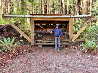
Blog #18 Sand instead of Snow, Rain instead of Snowflakes, Waves instead of Icicles, our 2nd winter on the road.
- Pamela Sonier
- Dec 16, 2025
- 56 min read

Updated: Dec 20, 2025
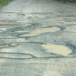
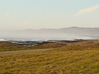
We woke this morning in a Casino parking lot where we boondocked overnight to the sound of rain pounding against the Roadtrek. After all, it is November, and from our point of view, on the road at this time of the year, rain sounds and looks much better than snow. After a 5-week hiatus in Coldstream, B.C. (big thank you to Dawna and Gilles) we are back on the road to complete the last 6 months of our 2-year road trip adventure. Yesterday, after a couple of stops to visit family and friends, we headed toward the Sumas USA border crossing with a bit of trepidation; as of lately, we have heard and read many negative stories about crossing the US borders. All these worries, though, turned out to be unfounded. The crossing experience was almost pleasant. We completed the entire process, photos and fingerprints included, in about 20 minutes. We were even thanked for being so well prepared. So here we are, our 7th back and forth crossing into the US in eighteen months. Should only be one more crossing left on this adventure - that is our return to Canada next April.
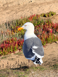
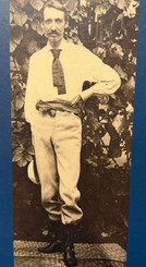
Our plan from here is to make our way down the Oregon Coast and beyond, hoping the weather will be in our favour. We told ourselves that if the west coast is too cold we would beeline further down for warmer weather. On our way, passing through Washington, we made a few quick stops. Renton Washington is a suburb just outside Seattle, and it is the final resting place of Jimi Hendrix. We both grew up listening to his music and have been fans our whole lives. Being able to visit here and pay our respects was quite an honour for us. Jimi Hendrix died on September 18, 1970, at the age of 27 after overdosing on prescription drugs. He was initially buried here beside his mother. As he was so famous, a continual stream of fans kept coming to his graveside to pay their respects. Because of this, Al Hendrix, Jimi’s father, wanted to create a memorial for his son. Once he regained the rights to his son's musical catalogue in 1995, plans began to build the Hendrix monument, which took a few years. In 2002, Jimi's body was disinterred and reburied beneath the monument. The family, which includes his mother, father, grandmother, and other family members are also buried on the same plot surrounding the monument. There are a few etched portraits of Jimi along with some of his lyrics in and around the monument. One thing we found surprising was that all the flowers adorning the monument, and there were quite a few, were fresh and healthy! Guy left a small stone on top of the guitar at the request of one person in the Roadtrek Group he communicates with - which was a very nice gesture.


Jimi Hendrix Memorial
As we always try to avoid the “big” cities, we decided to spend a day in Tacoma and bypass Seattle. We had a bit of a busy day here in Tacoma. Even here though, although a smaller city, it was still a bit enervating dealing with the busy traffic and trying to navigate to the places we wanted to see - but in the end, together we managed. Our first stop was the Bridge of Glass by Dale Chihuly, a famous glass sculptor and Tacoma native. The bridge is a pedestrian walkway over a busy roadway that displays 109 glass sculptures along the 80-foot “Venetian Wall”. Also here are the Crystal Towers, which are two 40-foot-tall structures resembling large pieces of turquoise in the form of trees. Of course, the day we were there, the museum was closed, but the bridge still gave us a glimpse of some of Chihuly’s work.


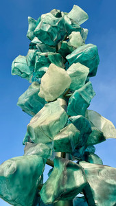

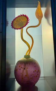
Venetian Wall and Crystal Towers
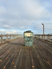
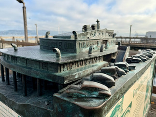
We always try to seek out monuments and stops with interesting stories and history, at least what we deem to be interesting. We did discover a few here in Tacoma. First is the “Top of the Ocean Monument” which comes with a very interesting story. Back in December 1946, a new restaurant called “Top of the Ocean”, which was shaped like a luxury ocean liner, opened in the harbour. The restaurant held over 700 guests and 20 private yacht moorings, and quickly became the “upper class” place to be in Tacoma. The multiple-level restaurant included a gaming area, private dining rooms, a lounge and bar, a dance floor, live orchestras, and private yachts accommodations. In 1948, the Tacoma Athletic Club bought the building and used the upper level as a private club to conduct both legal and illegal business. The club continued operating until April 3, 1977 when it was burned down. Arson was suspected and Dave Levage was charged with the crime. He pleaded not guilty claiming a skull fracture left him with a bad memory. But there were a few clues that connected him to the crime: such as a cab driver reported driving him to the restaurant and helping him move boxes of heavy liquid; a local hardware store employee said Levage had come in a few days before to buy 8 gallons of paint thinner; and Levage fingerprints were found on the liquid bottles at the crime scene. He was found guilty and sentenced to 20 years in prison. He was a “professional arsonist” who worked for “The Enterprise” which was then a local crime syndicate. “The Enterprise” had been behind a series of arson and firebombing across Tacoma, usually for a cut of the insurance money. The FBI, working the case, ended up charging 15 members of The Enterprise in 1978 with racketeering, arson, attempted murder, and more. Those charged included the ringleaders, mobsters John J. Carbone and George Janovich. Every member charged was found guilty for the crimes except, of course, Levage, as he was already imprisoned for the Top of the Ocean case. Today there is a boardwalk with a 30-inch scale model bronze replica of the restaurant at the site. The fine details of the replica are amazing: the band playing can be seen in the windows, people eating can also be seen in the windows, and vintage-style cars are parked on the outside. Remnants of the wooden pylons still remain at the site sticking out of the water.


“Top of the Ocean”
“We Honour a Hero” was the second monument we visited. This one has a bit of a tragic story. Back on April 13, 1949 there was a 7.1 earthquake in the Tacoma area. At the Lowell Elementary School, a six-year-old boy named Kelcy Allen was in the basement of the school when the earthquake struck. Eleven-year-old Marvin Klegman, who was a street crossing guard, spotted Kelcy and grabbed the younger boy’s hand, led him from the school basement, and threw himself on top of him when the bricks from the school began to fall. Marvin shielded Kelcy from the impact, but unfortunately, Marvin died instantly. Marvin’s death was in the papers, but his grief-stricken parents were reluctant to speak his name, and even his own brother grew up only vaguely aware that Marvin had ever existed, and so, Marvin’s story and death faded. Not long after the earthquake, Kelcy and his family moved to Portland, and Kelcy never learned Marvin’s name. Kelcy Allen spent his life feeling survivor’s guilt. In 2001, after the Nisqually earthquake struck the Puget Sound region, Kelcy was motivated to find the name of the boy who had saved him. He went to the Tacoma Public Library, searching through the Tacoma News Tribune files, and finally found Marvin’s name. Together with the help of a local philanthropist and friend of Marvin’s family, the statue was built at the Lowell Elementary School, and on September 11, 2003, the Marvin Alan Klegman Memorial was unveiled. Tacoma News Tribune article quotes Kelcy as saying, “All my life, I’ve seen myself as a 6-year-old, with this crossing guard. I began to realize that somebody in this life actually died for me, and it was a child. I have been blessed. I’ve been given something. I have been fortunate to live a really rich life. It’s part of me - part of my being.” Since that day at Lowell when he was six years old, Kelcy Allen has lived in Oregon, California, Hawaii, and other areas around the Pacific. He’s served in the Army, worked as a police officer, a videographer in Los Angeles, a flight instructor in Hawaii, a certified nurseryman in Portland, and, most recently, a cabinet maker. He’s wind-surfed in Mexico, bungee-jumped in Australia, and skydived in Oregon. “I have used every bit of my time,” Allen said. “I figured I better not waste it, because some little boy gave up his existence for me.” Although we said this is a tragic story, which it is, there is also a heartwarming aspect that someone so young had the courage to help someone in need and died doing it. For us, this puts into perspective how important and cherished every day in our lives really is.


We Honour a Hero
Next was one of Guy’s must see and do. The original Tacoma Bridge collapsed in November 1940. The bridge was built and opened on July 1, 1940 and was the third-longest suspension bridge in the world at the time - an architectural marvel for the time. On November 7, 1940 the bridge collapsed into Puget Sound. The bridge, which spanned the Tacoma Narrows strait, was built with a major design flaw that caused it to roll and sway in high winds. Even during its construction many of the workers nicknamed it the "Galloping Gertie." The reason the bridge collapsed was because of aeroelastic flutter. This occurs when vibrations in the structure alter the aerodynamic forces, which in turn feed back into the vibration, causing it to increase in amplitude and potentially leading to catastrophic failure, hence the collapse. No people died when the bridge collapsed but it did claim the life of a cocker spaniel named Tubby who was too scared to allow itself to be rescued from one of the abandoned vehicles on the bridge. The bridge was considered a total loss except for its foundation, the undamaged piers were reused in the reconstruction of the new bridge. All steel parts were recycled. It took the state of Washington almost ten years to rebuild the Narrows Bridge. This time though, it was aerodynamically designed to make sure that a similar disaster would never happen again. The newly rebuilt bridge was opened on October 14, 1950. To Guy’s delight, we drove over the new Tacoma Narrows Bridge. Guy had studied bridges while at SAIT in Calgary and was aware of this story.


Tacoma Narrows Bridge
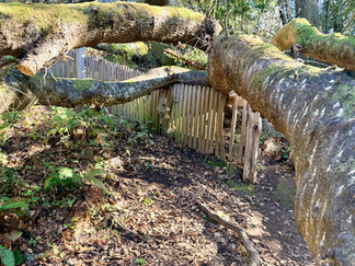
After Tacoma we decided to take a bit more of the scenic drive towards Oregon, trying to avoid as much freeway traffic as we could. We weaved our way along the beautiful and relaxing rural roads with a backdrop of huge cedar trees, fall foliage, and coastal views. We made a fun stop at the Hobbit House. This little house is tucked in the back of a garden center in Port Orchard Washington. Originally this garden center was wholesale only but when new owners purchased the business they wanted to attract the public to the store. The original idea had been to make a castle but that didn’t work, so one of the owners who was a JR Tolkien’s fan came up with the Hobbit House idea. It took six months to build. The frame is made of a 14-gauge galvanized steel culvert pipe. The walls are lined with wood and the outside is covered with stones and plants. There is a circular door and windows. Inside is a small stone fireplace, fireside tools at the hearth, carved seating areas, and there’s even a lamp on a tiny shelf. It is very cozy inside. A bit of a low ceiling as Hobbits were not tall. People from all over come here to pose at the house, some even dress up as sorcerers and elves….

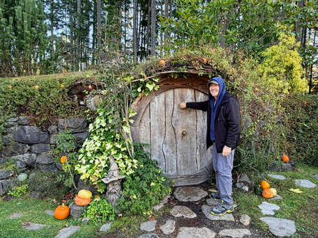


The magical Hobbit House
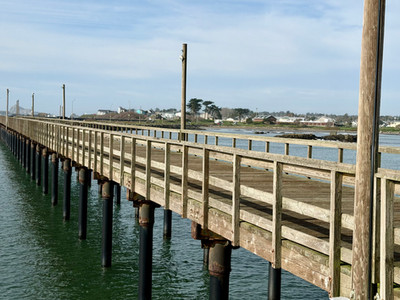
We drove over yet another long bridge, The Astoria-Megler Bridge. This bridge was built to replace the ferry system which had been the main way to cross the Columbia River to Astoria Oregon from Washington. The bridge officially opened on August 27, 1966 after four years of construction. This is the longest continuous truss bridge at 6.6 km long in North America and connects the states of Oregon and Washington. It stands 196 feet tall at its highest point, and is an amazing bridge to drive over. For us it was a bit reminiscent of the Confederation bridge to PEI, not quite as long though. Also unlike the Confederation Bridge, this bridge has no high side barriers so we could easily see the water below and ships in the distance.


The Astoria-Megler Bridge crossing from Washington to Oregon over the Columbia river
And now, just on the other side of the bridge, we arrived in Astoria Oregon. Astoria is a beautiful unique little town with beautiful old homes, quirky shops, and very steep hills and streets. I would not want to be driving or walking here during a snowfall. One of the things Astoria is known for are “Pigeon Steps”. These are unique sets of ridged stairs that were built in 1927 and designed by city engineer Alfred Tee. These were designed to give people traction on the steep inclines. These steps are more like a long steep ramp with small linear bumps for each step across the inclined walkway preventing slippage in wet and snowy weather. I found that they are actually not any easier to climb then regular stairs and because they are so shallow you have to almost do like half steps, I guess it makes you look like a walking pigeon, not sure? Locals here also call the steps “clickety clacks”. We gave it a go and counted 160 steps up. From the top the view was spectacular and well worth the effort.


Pigeon Steps - Astoria
The Astoria Column is the final monument in a series of historical markers that were erected by the Great Northern Railway to celebrate American westward expansion. The column's design is patterned after the famous Trajan's Column in Rome and features a spiralling mural (Sgraffito Frieze an Italian Renaissance art form that combines paint and plaster carvings) that depicts 14 significant events in the history of the Pacific Northwest, including the Lewis and Clark Expedition, and the arrival of the railroad. The column is constructed of steel and is 125 feet high and a diameter of 12 feet at the base - although it seems bigger. There is a 164 step spiral staircase to the top on the inside which Guy and I can attest to as we climbed them to the top for spectacular views. The column was built in 1926 and the original cost was $27,133.96 USD.


Astoria Column and views from the top
Next we went to the Pier 39 to check out the sea lions as they like to hang out in this area. They were at a bit of a distance across the water though - but we could still see them, and definitely we could hear them. There were two ladies there when we arrived. They had stayed at the hotel nearby and said they could hear the sea lions all night. They also said that the hotel even offered them ear plugs.


Noisy but cute, sea lions
Afterwards we went to Bowpicker Fish & Chips on a recommendation from Grant, my cousin Tanya’s husband, for fish & chips and we were not disappointed. This small popular roadside restaurant is built from a restored small boat and is parked just off the sidewalk on a side street. There was quite a lineup waiting to order when we arrived. We enjoyed conversations with a few people and we could still hear the sea lions from that distance. Interestingly, one of the gentleman we spoke with lives in Rainier about 50 miles away told us he has been coming here for over 20 years for the fish. The fish & chip was excellent.


Delicious fish & chips
Our last stop in Astoria was the 18 foot - Tall Toth Indian Head - “Ikala Nawan" ("Man Who Fishes") by sculptor Peter Toth an America Sculptor known as a humanitarian artist; of whom we saw another one of his sculpture in Valdez Alaska. Peter Toth embarked on a 20 year journey across America to create a Whispering Giant sculpture in each state to honour the Native Americans. Here in Astoria is his 57th "Whispering Giant” sculpture which he completed in 1987. It is carved out of a cedar log to honour the Chinook, Clasp, and all Northwestern Coastal Indians. Guy said there is no resemblance to Willie Nelson, like the one in Valdez Alaska.


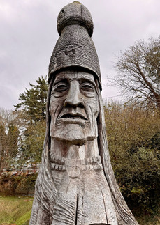


Ikala Nawan - Peter Toth sculpture
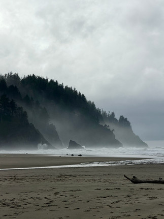
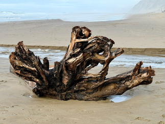
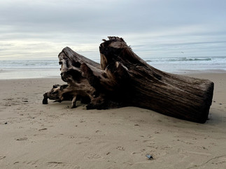
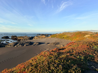
Welcome to Oregon, our first taste of the Oregon Coast, rugged, wild, and a continual anticipation of rain in the air. After Astoria we stayed a couple of nights at the Fort Stevens State Park, a beautiful quiet campground with giant trees surrounding our site. We were greeted with serene quietness with the exception of the, all too well known sound of continuous patter of the rain against the roadtrek. We took a nice walk along the beach to The Wreck of the Peter Iredale. The Peter Iredale was a four-masted steel ship that ran ashore in 1906 and is now considered to be one of the most accessible shipwrecks on the West Coast. During low tide people can walk up to the vessel's remains and explore. One of the main draws to this wreck is to take photos. With the backdrop of the waves, sea mist, and clouds, together with the wreckage makes it very picturesque. In 1906, the Iredale left Salina Cruz Mexico for Portland, where it was going to pick up a cargo of wheat for the United Kingdom. They managed to safely reach the mouth of the Columbia River early in the morning of October 25 after encountering heavy fog. As they waited for a pilot boat to guide them into port, a strong southeast wind blew and The Iredale ran aground at Clatsop Beach, hitting so hard that three of her masts snapped from the impact. None of the crew were seriously injured and Captain Lawrence ordered that the ship be abandoned. The wrecked ship became an immediate tourist attraction which it still is today, what is left of it.


The Wreck of the Peter Iredale
Seaside Oregon is a small town chock-full of interesting stories: some historic, some intriguing, and some a bit on the quirky side. As for the historic we did stop at the Turnaround which is supposedly the official end point to the Lewis and Clark Expedition, where they turned around to return to their home in St. Louis. There is a bronze statue of them there called “End of the Trail”. Also interesting is, near the statue area, is the Lewis & Clark Salt Works. The Lewis and Clark Expedition was camped nearby at Fort Clastop for the winter preparing for their return journey home. They had run out of salt which they needed for the winter and their journey home as salt was important for meat preservation. The rivers near Fort Clastop weren’t salty enough so a better place had to be found. A few men traveled south down the coast to find salt water which they did in Seaside. Making salt was a long and laborious ordeal. Sea water had to be collected and allowed to sit until the sand sank to the bottom. Three “salt makers” from the expedition then collected a large supply of firewood and built a stone furnace. Five kettles were placed on top of the furnace and had to boil 24 hours a day to produce salt from evaporated sea water. Captain William Clark and a few additional men rejoined the others at the salt works after about a week. The group stayed at the salt works for a few more weeks and then left with about 28 gallons of “Excellent, fine, strong & white” salt. Guy wants to add here that his name Sonier means “worker of the salt work” - just saying. Need we say, the rest is history.


End of the Trail - Lewis and Clark expedition


As for the unique, we visited The Sailors Grave. There is not much here, just a flagpole and a memorial stone with the message “Known Only to God” and “Found on the Beach April 25, 1865”. This grave site is the equivalent of the Unknown Soldier Tomb except this one is for sailors. The story here goes back to 1865 when John Hobson, a local, stated seeing three men come ashore in a small boat looking for fresh water for their fellow sailors onboard the main ship. The three left just as a storm started so Hobson lit a fire on the beach so the men could find their way back if the weather got too rough. Unfortunately, he found them on the beach the next morning deceased. He buried them with a small cross set as a memoriam. Their names and nationalities were never known. It is believed that there are dozens of other people buried on this beach from drowning mishaps – almost all with no identities. It is said that less than 100 years ago, as this area was uninhabited, it was deemed the perfect eternal resting spot for anyone landing here.


The Sailors Grave
Just outside of Seaside are a few of our quirky stops. First, the World’s Largest Sitka Spruce Stump and they are not kidding. This is huge! Originally the tree stood 216 feet tall but is was destroyed during a storm in 2007. The stump and remains of the tree have been left to slowly feed back into the earth. As we walked around the stump and explored, we really got the sense of its giant size.


World’s Largest Sitka Spruce Stump
A little further down the road is a small cemetery called Elsie Cemetery - no disrespect to the dead but as I have mentioned before I do have an interesting interest in cemeteries. Always, when we explore these final resting places, we have full respect and try to be as least intrusive as we can. This small tucked away cemetery has a full-sized metal crib marking the burial place of a baby, which in itself is extremely sad. There is also one with a deceased man’s cowboy boots, and many with homemade wooden crosses. It’s a beautiful graveyard surrounded by very large trees and plants, and a deep sense of peacefulness.


Elsie Cemetery
So far Oregon has greeted us with rains and winds but we are determined to enjoy no matter what. We decided to visit Canon Beach in the rain and wind to see the famous 235 foot Hay Stack Rock. This place ended up being a bit of a challenge to us. Once we started walking along the beach the wind, the rain, and the blowing sand were relentlessly pounding at us. We could barely move the wind was so powerful, my glasses were so soaked I had difficulty seeing, and the sand plastered our pants legs all the way up to our knees. Thank goodness we had worn good rain pants. We laughed, we took pictures as best we could, and had loads of fun despite being miserably soaked and cold.


Cannon Beach and Haystack Rock
We were told that of course we cannot drive down the Oregon Coast without a quick stop at the famous Tillamook Creamery. This Creamery produce over 500,000 pounds of cheese per day and there is a viewing area upstairs where we could watch the production line, which is quite interesting. We stocked up on a few different cheeses and of course enjoyed some of their famous yummy ice-cream. After our visit we safely boondocked just down the road at another creamery’s parking lot.
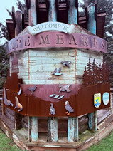
The next day we drove to The Octopus Tree located just outside Tillamook on Cape Meares. This tree is a Sitka Spruce believed to be between 250 and 300 years old. On that day it was rainy and foggy and the wet atmosphere we thought added to the tree’s mystique. This tree branches make a 90 degree turn at ground level and then reach vertically straight upwards. The tree is quite impressive at 105 feet tall with a circumference of 46 feet. What makes this tree most intriguing is that it has no central trunk. It extends from a central base but instead of shooting straight up with a central trunk, the body of the tree splits into a number of smaller trunks. What has caused the shape of this tree has been debated for many years as to whether it is due to natural events or influenced by Native Americans. It is said that native Americans in this area trained trees into an assortment of thick vertical trunks. These trees are common in the Pacific Northwest, and are known as culturally modified trees. Native Americans created these trees to hold canoes with corpses, in a practice known as "tree burial” and were also made to mark important places.


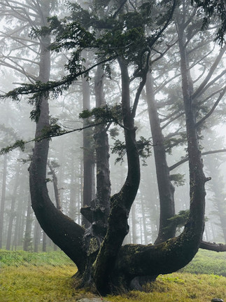
The Octopus Tree
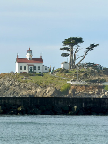
A short hike from the Octopus Tree is the Cape Meares Lighthouse. This lighthouse was built in 1889 and was named for Captain John Meares who was the first to sail into Tillamook Bay. It is the shortest lighthouse on the Oregon Coast at just 38 feet tall. Its light could be seen for 21 miles out to sea because of its Fresnel lens. The lens was made in France and shipped around Cape Horn, up the west coast to Cape Meares. It was then hauled 217 feet up the cliff by a wooden crane built from local wood.


Cape Mears lighthouse
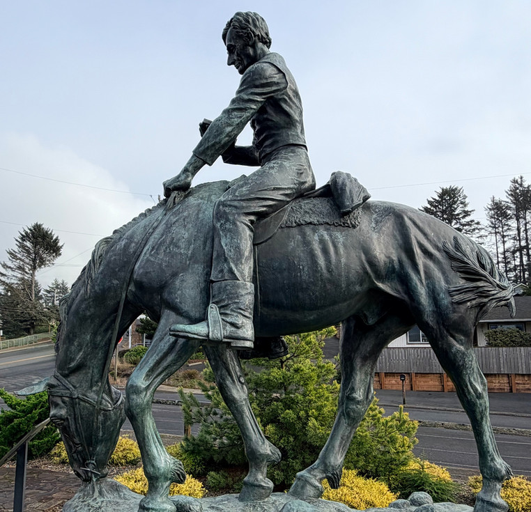
Down the road, in Lincoln City there are two statues with interesting stories. The first is called “Abraham Lincoln Reads on a Horse”. This statue is very well done and the likeness of Abraham Lincoln is spot on. Before becoming a president, Abraham Lincoln was a lawyer. He use to tour the Eight Judicial Circuit route through 14 counties in central Illinois for much of his legal career. He rode horseback on this circuit, often reading while traveling. He travelled with a judge and other lawyers to county courthouses to hear cases. In 1849 Lincoln was offered the job of Oregon’s territorial governor but he turned it down; he instead ran for President. The story behind this statue is that it was sculpted by Anna Hyatt Huntington and given to Lincoln City on the condition that the town never change its name. Lincoln City is actually five smaller coast towns that combined in the 1950s. Instead of naming the new town after one of the old towns, a new name was voted on. The school children of the area chose Surfland but the adults were not keen on the name. In the end they decided to name it after Abraham Lincoln and so it became Lincoln City. Another rather interesting part to this story is that Abraham Lincoln never actually visited Oregon.

Abraham Lincoln Reads on a Horse
The second statue here in Lincoln City is of Joe The Sea Lion. In March1936 Joe came ashore at the very spot where his statue is now located looking for a place to rest and recuperate. A local resident named Dave Dewey, found him on the beach, lassoed him and brought him up into the town, where a temporary fenced-in area was built. Joe repeatedly escaped his enclosure and wandered into local homes and yards where the residents soon discovered he enjoyed being sprayed with a garden hose and having his back rubbed with a broom. This funny behaviour made him a local celebrity, and it is said that as many as 5,000 people came to the area to see him. Joe even made the front pages of the Portland newspapers. A neighbouring town, reportedly envious of Nelscott's (Lincoln City today) publicity from Joe, complained to the county game warden that a wild animal was being kept as a pet. As a result, Joe was taken away from the town and released back into the wild, never to return.


Joe the Sea Lion - Lincoln City


Oregon Beach time
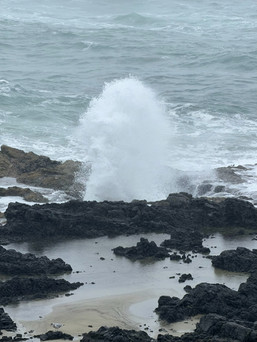
The Devils Punchbowl is a rock formation which was formed by the collapse of two sea caves. The sandstone walls are red and yellow and the black rocks on the floor of the Punchbowl are originally from its ceiling. When the tide comes in, the seawater churns and sprays upwards through the formation. The water crashing in and spraying from the bowl is almost violent to watch and it reminds us how powerful the ocean really is. The sandstone cliffs around here are said to be around 80,000 years old and we could see many signs of erosion and collapsing into the ocean. The area is fenced off with warnings not to climb along the cliffs but of course “crazy” people still do.


Devils Bowl Punchbowl
The Yaquina Head Lighthouse is 93 feet tall and is Oregons tallest lighthouse. This lighthouse began construction in 1871 and was first lit on August 20, 1873. The children of the lighthouse keepers and lighthouse visitors were not permitted to climb the 114 stairs in the tower because the US Lighthouse Service feared for their safety and risk of falling. The gaps between the balusters are wide enough that a small child could potentially slip or fall through. Unfortunately for us we were only allowed around the main level of the lighthouse because the upstairs part was closed for renovations so we could only see a very small portion of the staircase. This lighthouse also is equipped with a Fresnel lens that was shipped from France. In the 1930s the lighthouse power was changed from oil to electricity and in 1966, the era of the lighthouse keeper ended. This is one of the many lighthouses that were strategically planned along the Pacific Coast to allow mariners to sail the rocky coastline after dark. We visited just a few as some we went to see were not visible with the Oregon fog and rain. We walked around this lighthouse and the park area enjoying the views of the wide open ocean.


The Yaquina Head Lighthouse
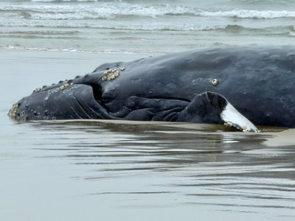
After a somewhat day of reprieve from the rain yesterday, we woke the next day to more rain and wind. Welcome to Oregon weather. Over and above the rain and wind, today started on a bit of a sad and somber mood, we stopped to see an alive beached whale just north of Yachats. The whale was a 1 to 2 year old humpback who had become tangled in crabbing gear. Experts had managed to free it of the gears but after many efforts it remained stranded on the beach slowly sinking in the sand, and was unable to return to the ocean. Volunteers named him “Hope” and for 45 hours they tried to save him. We were told that it is not uncommon to have beached whales along this coastline, but it is rare that they are still alive. Sadly, Hope was a rarity. Watching him breath and flip his tail as he lay on the beach was heartbreaking. We were also told that as whales swim in the ocean, they are weightless. And when they become beached, the weight of their bodies collapse and their vital organs as a result become compromised. Hope had been laying on the sand too long and unfortunately after 45 hours of trying to save him all efforts were in vain and he was humanely euthanized on the beach. To prevent animals and birds from feeding on the poisoned carcass, after being euthanized, Hope was buried in the sand on the beach.


Beautiful “Hope”
We continued heading down the coast towards Cape Perpetua to see Thor’s Well. To reach the site we hiked a 2 km trail, you guessed it, in rain, wind, and ocean mist. Everything was dripping wet and cold but the scenery was well worth the effort. Thor’s Well is like a geyser, as the waves crash onto the rocks, water spews straight up into the air through a hole in the rocks. The well started out as a sea cave dug out by the waves, and eventually the roof collapsed and created openings at the bottom and top through which the ocean waves splash through. The hole is around 20 feet deep. It is known as the drainpipe of the Pacific - it actually is a hole in the rock that appears to drain water from the ocean each time the waves crash into it. The spectacle was powerful and magnificent. It was amazing to watch as some of the waves were at least 20 feet high approaching the shore.


Thor’s Well
We have found through our travels that casinos are a great boondocking option. They are safe, quiet, and are usually open 24 hours so they have clean accessible bathrooms. Yet, the casino in Florence went way above that. They had a telecast sport section for betting where an NFL game was being shown. There were at least 6 televisions scattered around some of which were not being watched. The largest TV from which people were making their bets was at least 8 feet tall and 12 feet wide. Guy asked a floor manager if one of the televisions could be changed so we could watch the CFL Grey Cup. His response was “sure we can”. We were able to enjoy a couple beers and pizza, all reasonably priced, and watch the Grey Cup game on a smaller but still big screen TV, which we had to ourselves. I guess the Americans are not that interested in our CFL. One lady even suggested we should watch curling. Anyways, it was a wonderful way to end another rainy day in Oregon. Side note - happy the Riders won!


Go Riders! We had to cheer for the West
What a day today we went from sea lions to sand dunes. First we visited the Sea Lion Caves in Florence to see the Steller Sea Lions but unbeknownst to us the Steller Sea Lions are seasonal, and we were visiting during their off season - of course we were. We still went down over 200 feet by elevator to visited the caves. Steller Sea Lions are the largest of the eared sea lions. And this cave is the largest sea lion cave in America and the only known mainland rookery of the Stellar Sea Lion. They arrive inside the cave near the end of November to December by the hundreds and usually live in the cave until spring. Afterwards in the spring they move to the rock ledges outside along the coast for breeding and birthing - usually from April to early August. During their breeding they do not consume any food so after breeding time they leave for feeding and return back to the cave in November. We did go down over 200 feet to the caves which are at sea level via an elevator on the recommendations of one of the employees. We paid a discounted price and received a “rain check” so we can come back to see them in April on our way home, a win-win situation if we return this way. The ocean continually washes into the main chamber of the caves, which is about two acres in size with a vaulted rock dome of about 125 feet tall. The viewing area is fenced so people and seals do not intermingle. Down here, on the other side of the cave, there is another area we could walk to which opened to a beautiful coastal view. From a balcony at the rock the opening we could see up close waves crashing into the rocks and a more distant view of the famous 56 feet high Heceta Head Lighthouse. The powerful crashing of waves against the rocky shore never cease to amaze us. Also amazing are sea weeds that cling to these rocks and are battered by the waves everyday all day long, and yet are not broken down by this never ending onslaught and survive, even thrive.


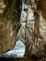

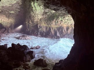


Sea Lions Cavesand a view of Heceta Head lighthouse
Another stop in Florence today for us was the Exploding Whale Memorial Park. There is no Whale Statue in memory of this story just a memorial park with beautiful views of the Siuslaw Dunes across the water. The whole thing is a bit of a comical story, the locals still make fun of it and in Florence they actually have an “Exploding Whale Day” celebration to commemorate it. Back in 1970 a deceased sperm whale washed ashore near Florence. This whale was huge, 45 feet long and weighed around 8 tons. The whale carcass was decomposing and the smell was becoming a problem. The people were unable to bury or burn the carcass because of its size. A solution was found and they decided to blow up the whale with dynamite thinking the pieces would blow up towards the sea. Unfortunately the plan was not fully successful. The whale scraps did not blow out to sea as planned, nor did it break into little pieces for the birds and crabs to eat. There was a spectacular explosion and huge chunks of whale blubber began whizzing towards the spectators who had come to witness the event and everyone became covered in pieces of dead whale. A car that was about half a kilometre away was crushed under one of the pieces. To make matters worst the explosion only made the decaying odour of the whale worst. After the failed explosion the remaining chunks on the beach were buried with a bulldozer. Every year, the people of the village gather and celebrate the ridiculousness of their mishaps. Poor whale….


Exploding Whale Memorial Park
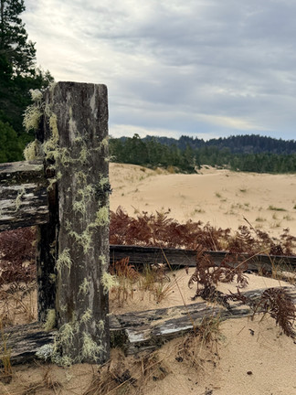
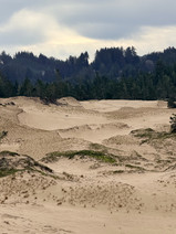
We stopped at the Oregon Dunes National Recreation Area and did the John Dellenback Dunes Trail which is hike leading up onto the giant sand dunes. Some of these dunes are up to 500 feet high. It was almost surreal with the unusual and unique trees we passed and the colours and patterns in the sand created by the wind. We climbed to the top and it was interesting to see how compacted and firm the sand was under our feet. The climb definitely got our heart rates going. The views were beautiful and Treme loved it.


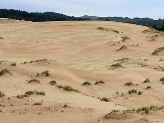


Oregon Dunes National Recreation Area
Shores Acre State Park, and just a few kilometres down the coast is Cape Argago State Park. These two areas are famous for storm watching. There is even a window sealed hut at Shores Acres to storm watch in. The area is beautiful with rugged cliffs and waves crashing. There wasn’t a storm while we were there but we could only imagine.


Shore Acres State Park
In between these two parks is Simpson Reef. This reef is home year round to the California Sea Lion, the Steller Sea Lion, and harbour seals. There is a great viewing area at a road pullout and from there we could see hundreds of seals frolicking in the waves, sunning on the rocks, and relaxing and running on the beach. Already when we stepped out of Roadie we could hear the sea lions far sooner then we saw them. There was lots of loud barking. I think we spent a good hour just enjoying watching them.


Simpson Reef with sea lions
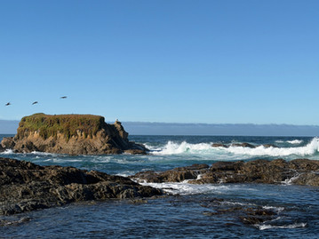
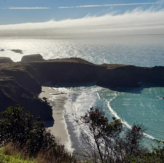
Coastal Oregon is scenic with its many rugged cliffs, coves, and beaches to explore and admire along the way. We have never tired of the views as around each curve in the highway there seems to be yet another view as beautiful or more beautiful than the last. Our last journey down the Oregon Coast was the Samuel H. Board and State Scenic Corridor which is again filled with beauty. We stopped at the Arch Rock. This is a free standing arch in the ocean that was created over thousands of years by the ocean waves. The waters in the area were deep blues and emerald greens which we have not really seen up until now. What awesome sceneries.


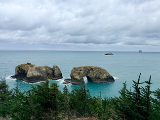


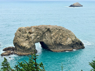


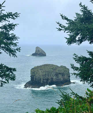
Arch Rock
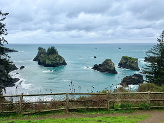
A bit further along the highway is the Natural Bridges. These are a group of natural sea arches formed as the ocean erodes cracks and crevices in the coastline, which develop into sea caves and eventually collapse to form arches. There are 7 arches in total. We did start down the trail but it turned out to be quite treacherous even dangerous as it was both steep and slippery. So after about one kilometre we decided it was safer to turn around. We did see two of the arches along the way, which were stunning. We have always said “ before anything else, safety is first”.


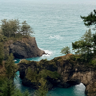


Starting along the Natural Bridges Trail
And now for Guy’s teenage bucket list, going to California. I know he has high expectations so lets hope California doesn’t disappoint and so far so good. Our first quick stop along the side of the road was to admire the “Sculptures made of Horseshoes” in Smith Rivers. There are a few sculptures here including a stagecoach, horses, and a farmer training horses. There is no official number as to how many horseshoes were used and we have tried to find the answer to this to no avail. This was an interesting and fun display to admire. It took quite an artist to do that - proportions are perfect.


Welcome to California!
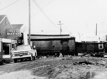
Crescent City was our first stop in California. This town is known as "Tsunami Central" due to an underwater ridge just offshore known as the Mendocino Fracture Zone which funnels tsunamis into deeper water where they pick up speed before they hit Crescent City. The city has suffered more tsunami damage in the past 150 years than any other area on the U.S. west coast, outside of Alaska. Since 1933 when the first tide gauge was installed here, there have been 41 recorded tsunamis. There are 2 types of tsunamis: ones that are triggered by earthquakes in distant places and ones that are triggered by local earthquakes. Distant earthquakes create waves that travel thousands of miles across the ocean. For these tsunamis there may be hours or days of advance warning but for local earthquake tsunamis it could be only minutes. Guy and I have noticed a lot of signage indicating tsunami evacuation routes. The biggest tsunami here was caused, in 1964, by the Good Friday Earthquake which started all the way from Alaska. Five tsunami waves swept into Crescent City killing 11 people, injuring more than 24 people, destroying 29 city blocks of buildings, and causing more then 15 million dollars in damages. The Good Friday Earthquake caused the worst tsunami damage along the west coast. Crescent City has a short “Tsunami Walking Tour”, about one kilometre walk, in the downtown and waterfront area with informative panels describing and telling the stories of tsunamis that occurred here.


Crescent City
Also in Crescent City, there is a lighthouse here called Battery Point Lighthouse which is only accessible during low-tide; low tide creates a natural bridge to the small island where the lighthouse is situated. Interestingly during the 1964 tsunami the lighthouse keepers were trapped on that small island and survived. The lighthouse itself did not sustain any damage and sadly the keepers could only watch as the tsunami swept into their town.


Battery Point Lighthouse
Another interesting tsunami story mentioned here starts in Japan on March 11, 2011 when a 8.9 magnitude earthquake struck Japan. This earthquake was so strong it moved Honchu, the main and largest island of Japan, by 8 feet to the east. People along coastal Japan had very little time to respond and 18,000 people died and of those deaths 1800 were in Rikuzentakata. Interestingly, two years after the tsunami a 20-foot boat named “Seagull” was discovered washed ashore at Crescent City. Japanese written characters on the boat suggested that it may be tsunami debris from the 2011 tsunami in Japan. Photos were taken and posted on a Facebook page and it took a few days to trace the boat back to the Takata High School in Rikuzentakata. High school students in Crescent city worked together to clean the boat and eventually returned it to the high school in Japan in October of 2013. From this gesture it was discovered that these two cities have many things in common like size, an affinity with the sea, a working class economy, and tsunamis. The two cities have officially become Sister Cities and continue to host exchanges between students and professionals. There is a beautiful mural here depicting this story.


Mural - “Seagull” the boat - Japan tsunami 2011
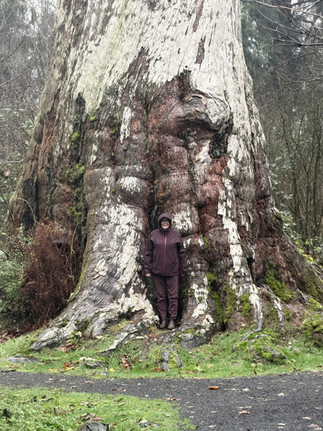
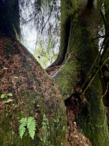
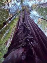
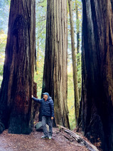
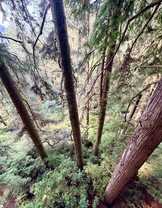
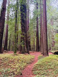
The northern part of California for us has been a combination of ocean coastline views and the Redwood and Sequoia forests and giant trees. We really immersed ourselves here. First we camped in Jedidiah State Park for a few days and this campsite was spectacular. We were surrounded by the ever giant presence of Sequoia and Redwood trees standing magnificently all around us - and we could feel a sense of their strength, and perhaps even wisdom, peace, and solitude. Not far from the campsite we did a drive down Howland Hill Road to see more giant trees and a walking trek to the Grove of Titans. This is one of our favorite drives.vThe Howland Hill Road was fun to drive on. It is a very narrow dirt road that was once a stagecoach line winding between trees. For most of the road it is only wide enough for one vehicle, and sometimes feels as if it is barely wide enough for Roadie. Luckily there are many pullovers to meet other vehicle to let others pass. There are nonstop views of gigantic trees. Some trees are so big that while driving some of them actually encroach onto the road and are as wide as the road itself. The narrow road makes its way twisting and winding around them. Some are so close to the road that we could almost reach out our windows and touch them. There are definitely no roadside barriers here so we drove very slowly and carefully, but what an incredibly beautiful drive. It was a lot of fun and we both thought “we certainly would not want to be doing this in the middle of summer in high tourist season”, there would be never ending traffic congestions and lineups to get around some of these bends.


Jedidiah State Park Camping


Beautiful Howland Hill Road drive
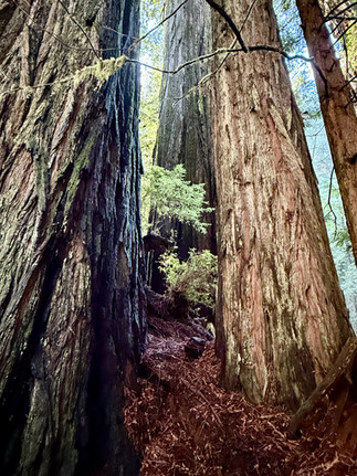
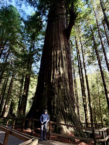
After about 30 minutes of very slow driving, we stopped at a parking area where we could hike the Grove of Titans Trail. This majestic tree grove at the end of the trail contains many tall, wide, and massive redwoods and sequoia trees. This area has been known by indigenous people for thousands of years. One tree, which we had a photo taken in front of, we were told is 1300 years old, and may be older. In the late 1990’s this grove of trees was "re-discovered" and named “The Titans”. Many people started coming to see the trees and much damage was done to the forest from people trampling all over to see them. In 2022 this new walking trail was completed with 1500 feet of elevated boardwalk built to protect the forest floor and to allow people easy access to the giants. The trail is fascinating to walk along; at times even difficult for us as we kept staring upwards in awe and forgetting to look down at our feet and watch where we were walking. We made so many stops along the way to take photos which Guy kept saying “these photos cannot do this place justice”. “These photos cannot possibly show the sheer size of these trees.” After about a half hour of trekking, we reached the Grove of Titans and we were absolutely awestruck at the sheer size of the trees. They are monsters in comparison to what we know as “large” trees in Canada. The only possible comparison in Canada would be the trees at Cathedral Grove on Vancouver Island.


Grove of Titans Trail
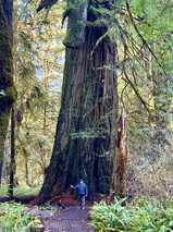
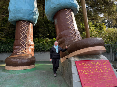
Another one of our awe moments visiting the giant trees is The Trees of Mystery, a private 120 acre park with interesting and educational trails amongst giant trees. Among many others, the main attraction here is an aerial skywalk with swing bridges crossing from trees to trees. First we walked a trail up the side of a mountain and then we climbed a ladder up the trunk of the first tree where the swinging bridge walk started. While walking on the skywalk, over 100 feet high, we would look way down and realize how high we really were above the ground - a little dizzying. But when we looked up, we were still not able to see the tops of the trees, some are well over 200 feet. Really amazing! There is a Sitka Spruce that is 180 feet tall, the cathedral tree which is a group of 9 redwoods that form a “cathedral” and believed to be between 600 - 800 years old. But one of the most interesting and magnificent trees here is the Brotherhood Tree. This tree is huge 19 feet wide, 297 feet tall and is said to be one of the largest living things on earth - the owner of the park says it is at least 3000 years old. When scientists climbed to the top they found quite a few different types of life. There was a bat colony, a flying squirrel nest, ferns, and surprisingly salamanders. Over the years the owners of this private park has allowed for cuttings to be taken from this tree, and new saplings from these cuttings replanted all over the world.


Trees of Mystery


The Brotherhood Tree
On the funny and entertaining side, Trees of Mystery park offers a walk through the trees with wood carvings displaying the life of the fictional character Paul Bunyan from birth and his Blue Ox, Babe, as well as oversized mosquitoes, dogs, and squirrels. And of course, a carving of Paul Bunyan’s sweetheart, Lucette.


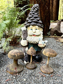


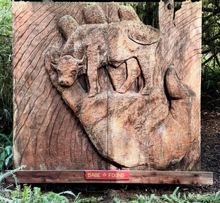


Just a few of the fun carvings around Trees of Mystery
Included in the entry fee was a gondola ride to the top of the mountain for top of the trees views which we kept for last. After the Paul Bunyan walk we rode up the gondola, a 15 minutes ride to the top. At the top we enjoyed the views, took a few photos, relaxed, and rode back down. Fun stuff!

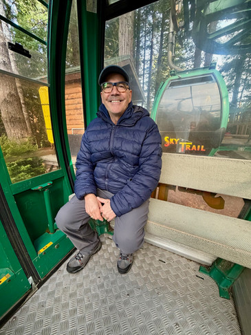

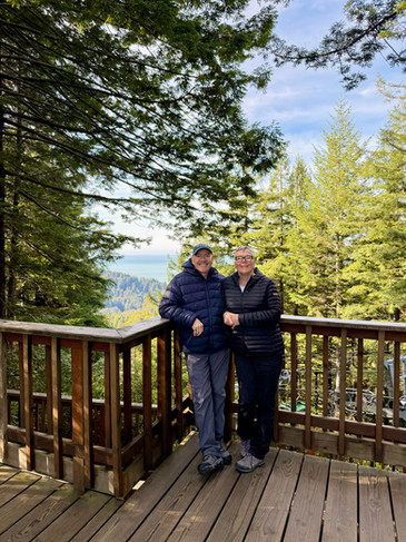
Gondola Ride top - Trees of Mystery
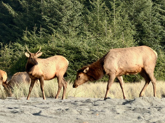
And even after we said no more rough dirt roads, here we are traveling down yet another dirt, winding, potholed, mucky road to Gold Bluff Beach Campground and a hike to the Fern Canyon. Unfortunately the road onwards to the Fern Canyon was washed out with creeks crossing, so we were unable to go, but we did enjoy a few wonderful and peaceful days at the campground. This is not a big campground and the sites are a bit small and more designed to accommodate tents then RVs. Thankfully Roadie is under 20 feet and fitted perfectly. The sites are right on the beach and we could hear the waves crashing on the shore all day and night. And, lucky for us we even saw a herd of elusive Roosevelt Elk wandering along the beach and into our campsite. Elks on the beach seems a bit odd as back home we associate elks with mountains, but we are in California now and there are some low mountains in the background.


Road to Gold Bluff Beach Campground


Gold Bluff Beach Campground
All is not always great and beautiful for us on the road. And when things happen, they seem to all happen at once, I guess. Last night our dear Treme decided to projectile vomit all over her bedding, floor, and the rug. This is the first time ever in all the years we have had her. Today we have been trying desperately to find a laundromat but as it happens, today is the American Thanksgiving and almost everything is closed. We’ve been told that Thanksgiving here is a big holiday, some say even bigger than Christmas, and judging by the amount of traffic on the road, and by having all businesses closed, it certainly feels like it is. Laundry will not be happening today - we’ll have to sit in a stinky Roadie for one day. Now we might have thought, well this isn’t too bad of a situation but now our dear Roadie has decided to also get sick. She developed a cooling fan issue so we now are waiting in Eureka California until Monday after the Thanksgiving weekend for the Dodge Dealer to reopen and have her checked out. We ended up boondocking in a Casino parking lot for the first night in Bear River just outside Eureka. This nice casino is opened 24 hours and every time we went in to use the washroom the security guard at the front door would open the door for us, it felt a bit odd but we went along with it.… For the next following days we have found a campsite with full hookups and showers to wait it out until Monday morning. Life on the road has its ups and downs just like it would at home. Any thing can be overcome though. So we planted ourselves here for the next few days and enjoyed our time.


Eureka, California
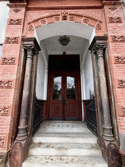
While in Eureka we did wander around town to check out a few things and our first stop is worth a mention because this building is so striking. It is the Carson Mansion. This house was built by William Carson who came to California during the Gold Rush of 1849 -1850. He did not strike it rich with gold but he did become rich as a successful business man. Between 1884 to 1885 he built this beautiful home which has 18 bedrooms and features rounded Moorish arches, lavish redwood carvings, and ornamental balconies. The house is a combination of many Victorian Styles, and is said to be the inspiration for the Disney’s Haunted Mansion. We would have loved to be able to go inside but we could only admire it from the sidewalk as it is now the Ingomar Club which is a very exclusive private club and only members are allowed inside.

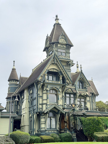


The Carson Mansion
We did another stop to check out the Gabriel’s Garden. Romano Gabriel had spent over 30 years making folk art sculptures out of vegetable crates that he displayed around his home in Eureka. He was born in Italy in 1887, came to America in 1913, and served in World War I. After the war he worked as a carpenter and gardener in Eureka. He did his work in a small shed behind his home creating most of the pieces with a hand saw and other hand carving tools. Some of his pieces were animated by motors. Eventually his Folk Art Garden grew with all his art pieces and his home was almost hidden behind all his sculptures. His Folk Garden became known nationally and internationally and became quite a tourist attraction. In 1977 Romano died and that same year his Sculpture Garden became a designated cultural landmark and is now displayed in downtown Eureka behind a locked two-story glass enclosure. With the reflection of the light it was difficult to really see the entire display but what we did see was fun and whimsical. I am a big fan of the Folk Art style mostly because I find that the people who create this style of art have some of the most interesting and unique, yet simple life stories.

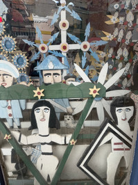


Gabriel’s Garden
After our stop in Eureka, Treme feeling better and Roadie all tuned up, we were all roaring to go. We hit the road to finish exploring the northern part of California with more majestic Redwood and Sequoia Forests; and of course, more beaches and seaside sceneries. We drove down the Avenue of the Giants which is about a 50 kms scenic highway surrounded by giant trees with many possible roadside stops to explore, which we took full advantage of. The Coastal Redwoods grow in groves between other kinds of trees and plants and sometimes small towns situated in between as well. The coastal redwood is the world's tallest tree at up to 70 feet taller than a giant sequoia, and has a more slender trunk than the sequoia. Our first stop was a hike in the Grieg-French-Bell grove where there are trees standing up and erect and almost as many fallen laying on the ground, these fallen trees nourish the growth newer plants around them.


Driving down The Avenue of Giants


Grieg-French-Bell grove
Next was the Immortal Tree, which is almost 1000-year-old redwood. This tree has survived lightning, fire, floods, and of course loggers. The tree was once 298 ft tall, but now stands at 258 feet due to the top knocked out by lightning, and has a base diameter of 14 1/2 feet.


The Immortal Tree
We did a few more shorts hikes in Founders Grove. This area is where, until 1991, the tallest tree in the world stood; the 362-foot-tall “Dyerville Giant” Redwood Tree stood a good 60 feet taller than the Statue of Liberty, and was estimated to be about 1600 years old when it sadly fell over in a rainstorm. The crash to the ground moved the earth so much that it registered on a nearby seismograph and one local person heard the crash at one kilometre away, and thought a train had crashed. The Rockefeller Forest spans 10,000 plus acres and is one of the largest old-growth forests in the world. We did a 3-kilometre hike through these trees. Trees, trees, giant trees everywhere.


Founders Grove and Rockefeller Forest
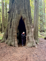
The Living Chimney Tree is near the end of the Avenue of the Giants. Back in 1914 the tree suffered from a fire which lead to the center of the tree being completely burned out. This fire created a hollow space about 12 feet wide at the bottom in the centre core of the tree. The Living Chimney Tree is about 78 feet tall, is healthy, and still living. We were able to walk inside the hollow trunk, looked up, and we could see the sky all the way up. The wood inside still has burnt signs from the fire.


Living Chimney Tree
Last but not least for us is the very famous Chandelier Drive Thru Tree. This tree is a 276-foot tall coast redwood with a 6-foot-wide by 6-foot-9-inch-high hole cut through its base to allow a car to drive through. Unfortunately for us we could not drive through with Roadie who stands at 9’6”. But we at least did a “walk through”. There were lots of people doing the drive through. We can only imagine this place during high tourist season and the line up. There is also a full park here with many wood carvings scattered throughout.


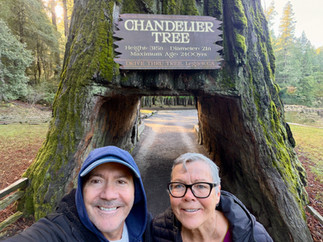


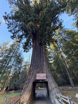


Chandelier Tree
After the incredible and unforgettable giant trees experience, we headed south towards the California coast to travel further down the coastline where the skies are open. The canopy of the giant treed forests have made it seem like the skies are always covered, it always felt like dusk. The trees hold the light at the top and let very little reach the ground. But we still very much enjoyed our time among these majestic giants; we will forever remember the peaceful and awesome feeling they have instilled in us. As we have said pictures cannot possibly do this justice and definitely neither can words, but we try. These trees, they engulfed, captured, and awed us. An experience to remember for the rest of our short lives.
Fort Bragg is known for sea glass along its beaches. Sadly we arrived at high tide so we only caught a mere glimpse of sea glass as we walked along the rocks. The views were beautiful. The sea glass comes from bottles and other debris that was tossed over the bluffs when the area was used as a trash dump site in the-early to mid 1900. The glass colours are vibrant from reds, yellows, forest greens to soft lavenders, and aqua marines and vary in sizes. After the beach, we stopped downtown for a quick visit to the Sea Glass Museum. On display is over 3000 pieces of many colours of sea glass. This small museum displays Capt. Cass Forrington’s collection, a retired former deep sea captain.


Seaglass beach


Sea glass display at the museum
Also in Fort Bragg, we made a quick stop at The Triangle Tattoo & Museum. This is a tattoo shop with different sections of memorabilia, stories, pictures, and artifacts on the history of tattooing. They are quite strict with not allowing any photography due to the sensitive nature of some of the areas like “Tattoos without Consent”. In this area there is information and stories how in ancient China authorities used facial tattoos as a punishment for certain crimes, and or to mark prisoners and slaves. In ancient Japan and Korea people who had committed crimes would have their crime tattooed onto a visible area of their skin. And of course The Holocaust where guards tattooed prisons with identification numbers. Also a section on illegal Japanese mafia members tattoos. There is loads of pictures on the different styles of tattoos from Americana, Tribal, to New School.
There is a section here called the Circus where there were many interesting stories. One that really intrigued us was about The Great Omi. We could take photos in this section. Originally named Horace Ridley, he was born in 1892 in Surrey England to a well to do family. During his childhood he had a tutor who had spent his younger years doing horseman stunts in the circus and this inspired Horace in his later years. After his father died he received a large inheritance which he proceeded to spend quite quickly with parties and gambling. With no money left he decided he would become a professional freak show and sideshow performer. In 1923 he got a few tattoos and was displayed in a small side-show, but he wanted bigger. So in 1934, with the help of English tattoo artist George "Professor" Burchett he decided to get himself completely tattooed. He endured more then 150 hours of tattooing and turned his full body into a Zebra. Along with these tattoos he had his nose pierced by a veterinarian where he inserted ivory tusks. And he also filed his teeth to sharp points. Horace Ridley became known as “The Great Omi” and/or “Omi the Zebra Man”. He became famous and toured with Ringling Bros and Barnum & Bailey. In 1941 he left Ringling Bros and toured Australia and New Zealand becoming one of the highest paid showmen in both hemispheres. He retired to Sussex England and passed away in 1969.


Triangle Tattoo & Museum
After our stop in Fort Bragg we have decided to take what we call the “road less travelled” - the highway 1. This highway stretches down the California Coastline so we figured it would be filled with nice beautiful sceneries instead of the main freeway. Well the scenery was beautiful with rugged coastlines and unobstructed views of the Pacific Ocean for about 150 km to our next destination. But we swear there was not one straight section of road longer than ¼ of a kilometre on this crazy road. The road was narrow, with no shoulders to speak of, no roadside barriers and went up and down mountain faces. It weaved and snaked its way around from one sharp curve to another. Many of curves were switchbacks with speed limits down to 15 kms per hour. On the passenger side, we could see straight down to the beach below at maybe 500 feet - but it was paved. Guy said he was happy to be the driver on the centre line side. Funny thing is, at one point, when we were way up there snaking around the hillsides, there were actual “Cattle Crossing” signs with Texas gates across the road. We saw no cows and still have no idea where they were or even how they would have gotten up there.


Winding and weaving California highways
We stopped along many numerous vista points so Guy could get a chance to admire the views. I felt sorry that he was so focussed on the twisty road that he could not fully see and enjoy the amazing sceneries. That road required 100% of his driving concentration. One of our favourite stops along the way was the Harbour Seal Nursery with an area of rocks and beaches where the harbour seals give birth and nurse their babies from March to July. There were quite a few seals lounging about. Most of them just laid about enjoying their day. They laid so still, we initially thought they were all dead - some were on their back and others on their sides and bellies. But then one would move a bit, just enough to roll off the edge of the beach and into the water for a swim. This was such a fun stop.


Harbour Seal Nursery Views
The last few evenings we have been camping along the beach. We are truly blessed to fall asleep and awake each morning to the sound of the waves as they crash on the beach. On our drive the following morning we stopped to watch surfers doing their things in the waves with pelicans flying just above them, seemingly playing with the surfers.


Before arriving in Santa Rosa we made a fun stop in Sebastopol to check out Patrick Amiots “outdoor art gallery.” Patrick is a Canadian-born artist known for creating large Junk-Art Sculptures and his wife paints them with bright colours. Patrick and his wife live in a neighbourhood in Sebastopol on Florence Avenue where neighbours display his art work on their front lawn for people to admire. Over the years he made and freely donated many of his creations to his neighbours. We walked up and down the street admiring and sometimes giggling at these fun and whimsical creations. I said to Guy ‘I want to live in this neighbourhood’.

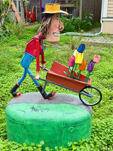


Patrick Amiots “outdoor art gallery.”

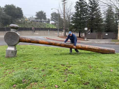


A carpenter’s dream?? No says Guy. 800 Pound Hammer - 21-foot-long redwood handle and a six-foot-high steel hammer head. Healdsburg California


Towering Pillar of Bicycle Parts - 65 feet tall 340 discarded bicycles and parts frames, wheels and gears. Santa Rosa California
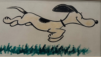
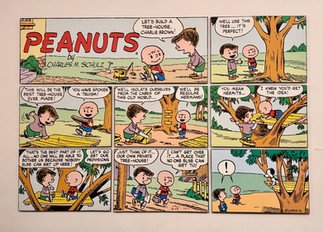
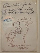
Now who doesn’t love Charlie Brown? Well we do! We travelled next to Santa Rosa to visit the Charles M Schulz Musuem. The museum is very well done with so much interesting history and stories about how Charlie Brown was created. This is now mid December a couple of weeks before Christmas, and at the entrance of the museum there was a replicate of the famous “Charlie Brown Christmas Tree” on display.

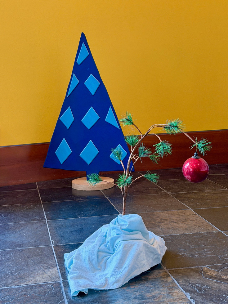
A Charlie Brown Christmas Tree
Charles Schulz drew the comic strip for 50 years from 1950 to 2000. In total there were 17,897 Peanuts comic strips written and illustrated by him. The comic strips started on October 2, 1950 and continued until the final Sunday the strip was published on February 13, 2000, the day after his death. Originally he wanted to call the strip “Li’ll Folks” but the newspaper didn’t like it and came up with the name Peanuts, which Schulz never particularly liked. Through the years he created over 70 characters. We never realized there were so many in the peanut gang. Shultz’s favourites were Linus, Charlie Brown, Lucy, and of course Snoopy. He named the dog Snoopy because his mother always liked that name for a dog. In real life Charles Schulz dad was a barber just like Charlie Brown’s in the comic strip. Charles used the term “security blanket” for Linus blanket, and in 1981 the Oxford English Dictionary adopted the term. Another interesting fact is that Schultz apparently found words that started with the letter B to be funny. Also interesting is that Schultz famously used a four-panel format for his strips, which cemented that structure as a standard in the USA. The museum has two levels with so much interesting stuff. The first level focuses mostly on the history and development of how the Peanuts gang came about. On the second floor there is a replica of Schultz’s working space, including his original desk and chair. There are also original doodles, notes, and the original script for the Charlie Brown Christmas show - all behind glass of course. In the movie, Charles insisted that the voices actually be of children, to keep with the authenticity. To this day Charlie Brown Christmas is still one of my all time favourites.


Charles Schulz Museum
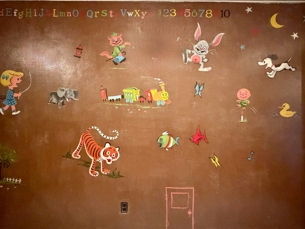
One very interesting story in the museum is about “The Nursery Wall”. In 1951 Charles painted a mural for his daughter Meredith at the family's Colorado Springs home. In 1952 they sold their home and the new owners painted over the mural at least four different times over the years. In 1979, Polly and Stanley Travnicek purchased the home with prior knowledge of this mural. Polly learned from Schulz that he had used oil paints for the mural so she bought cans of sanding liquid and cotton balls and worked on the 96-square-foot wall one inch at a time for 3 months. She stated "I was so happy. For weeks, I'd rub and say, “Where is Charlie Brown? Where is Charlie Brown? I know he's here somewhere? And, finally, there he was!". Once they learned of Schulz's upcoming retirement, the Travniceks donated the mural to the Charles M. Schulz Museum and Research Center for permanent display upon its opening in 2002. The wall was removed from the Travniceks' home in September 2001 and transported to Santa Rosa in a temperature-controlled truck. When you look at this mural you can clearly see Charlie Brown, Snoopy, and Patty.

The Nursery Wall
Another couple wonderful pieces of art in this museum are the Tile Mural and the Morphing Snoopy Sculpture. These two pieces were created by Japanese artist Yoshiteru Otani who is a long time fan and admirer of Charles Schulz and his Peanuts work. Otani described his connection with Schulz through their art: "The conversation between us was like the communication between Snoopy and Woodstock. We didn't talk but we understood each other". The Peanuts Tile Mural is 22 feet high and is made of 3,588 small ceramic tiles, and each tile features a drawn Peanuts comic strip. The comic strip details on each small tiles can only be seen and read from very close up. While looking at it from a distance, one can only see the obvious large image of Lucy holding a football for Charlie Brown. Very artistically well done.


The Peanuts Murals - up close look at the tiles
The second piece is Morphing Snoopy which is a 26 foot long bas-relief sculpture made of 43 layers of maple veneer that shows Snoopy morphing from Schultz’s childhood dog Spike to the comic strip Snoopy. This piece is hung quite high on the wall, so it was not as easy to see, but still quite amazing and well done.


Morphing Snoopy
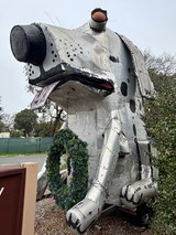
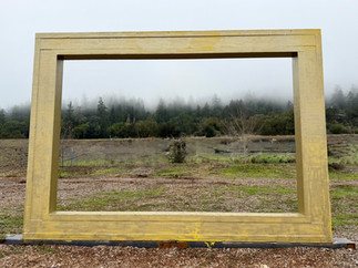
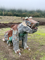
We worked our way towards the Francis Coppola Winery Movie Museum. Along the way we made a stop a Wilson Winery to see a steel 26 Foot Tall Coyote sculpture. This giant 7-ton coyote sculpture was designed and sculpted out of steel by artist Bryan Tedrick for the Burning Man festival in 2013. The Burning Man is an annual event in the Nevada desert. Further down the road, in the same area, is a display of about 20 metal sculptures standing just off the highway. There is a huge metal horse sculpture called "Victory", a “Barrel Man” made from the metal rings from wine barrels, a swarm of flying butterflies made from railroad spikes, a beautiful Native American sculpture called “Chief Steel Feather”, an interesting fish sculpture called “Geyserville Rebirth”, and one of my favourites a large picture frame called “Frame of View” which is an open picture frame that allows the imagination to go wild, perhaps.


Sometimes, following me, Guy ends up in the strangest places.. But he loves it!


Geyserville Metal Steel Sculpture Garden


More spectacular metal sculptures along the way, a warthog
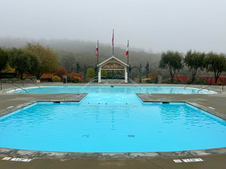
The Coppola Winery Movie Museum. This winery sits on a 57 acres. We must say that driving down the long elegant driveway to the winery was a bit intimidating for us with its grandiosity and with a bit of that Hollywood flare. Although we both like our wine we did not come here for the wine, we came to check out the movies exhibits. The winery is stunning though with different bar areas for wine tasting and a restaurant serving martinis. We were surprised to see so many people here on an early Sunday morning already enjoying the wines. We wandered around and admired the exhibits. One of our highlights was seeing, touching, and standing in front of the original desk that was used in all three of the Godfather movies. We could sense the imposing importance of this piece. Another highlight was seeing a second draft script of the first Godfather movie, of course behind glass. There was a display of all the oscars, nine in total, and awards won for the Godfather trilogy movies. There is Dennis Hoppers’ outfit and cameras, Robert Duvall’s cowboy boots and cavalry hat, as well as a pile of skulls, arrows, and a bamboo prisoner cage from the Apocalypse Now movie. There were photos of Marlon Brando and other cast members. The walls are full of movie posters and family photos.

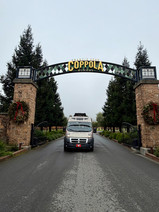


Outside The Coppola Winery Movie Museum


Inside The Coppola Winery Movie Museum
Our last stop on that day was at the Old Faithful Geyser in Calistoga California. This is one of only three official “Old Faithfuls’ in the world. Old Faithfuls are named for their predictable pattern of eruption. The most famous geyser is in Yellowstone National Park. And the third is in Iceland. The Old Faithful in Calistoga erupts every 30 to 45 minutes for about 3 minutes. For the time we were there visiting, we experienced the blowout twice. It is quite interesting to watch. First it starts with an increase of steam coming out of the hole, then boiling bubbles appear in the water around the rocks close to the opening, then there is a gurgling sound, and then the water spews straight upwards to about 50 feet or more.


California’s Old Faithful
In St Helena we visited the Robert Louis Stevenson Museum. The museum is just one small room connected with the library. There were not a lot of artifacts from his lifetime mostly old photographs and hand written notes. Stevenson is a Scottish author who wrote quite a few classics like the novella The Strange Case of Dr. Jekyll and Mr. Hyde which we discovered he wrote in just 6 days when he was confined to his bed in 1885 due to sickness. He also wrote Treasure Island mainly to entertain his young stepson Lloyd during a holiday in 1881 beginning from a map they drew together featuring an island with buried treasures. Stevenson was quite adventurous, he loved the South Seas and would spend much of his later life there. He canoed in Belgium and France and while there he met his great love, Fanny Osbourne. Fanny was an American woman 10 years older then him who was a divorcee with 2 children. He traveled to America and there they got married in 1880. In 1888 Stevenson and his family sailed from San Francisco on the yacht Casco to Marquesas, Tahiti, and Hawaii where he met King Kalakaua, the last King of Hawaii. The couple ended up purchasing land and lived in Samoa. Eventually they were to return to England but due to Stevensons ill health they stayed in Samoa where on December 3, 1894 he died from a brain aneurysm. A the museum there is a note written by Robert Louis Stevenson which is an excerpt from his final work “Wier of Germiston” which is regarded as one of his most powerful works, even though he did not finish it before he died.


Robert Louise Stevenson Museum, St Helena


St. Helena California
We traveled through the famous and incredibly beautiful Napa Valley which is estimated to have over 400 wineries, and we can believe it. Everywhere we looked there are wineries after wineries stretching across fields and hills. They look so well organized with their perfectly straight rows of grape vines. It makes for beautifully peaceful scenic drives. There also seems to be a constant layer of cloud and fog in this area, which gives it a bit of a mystique mood.


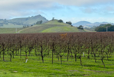
Napa Valley scenery


A different view of Napa Valley
In Napa I visited the Napa Toy Musuem. This museum is a labour of love for the owners Charles and Maggie who lucky for me were both there the day I visited. They had a wealth of information, history, and stories about the numerous toys in their museum. There were collections of Ken and Barbie dolls on loan from a friend, many different types of wooden toys, papier-mâché toys, painted cast iron toys, wind up toys, stand still banks and over a 100 mechanical banks here that are Charles favourite and he loved showing me. Each of these mechanical banks does something different when a penny is put into them. These toys date from 1890’s to the 1960’s. One of the most amazing pieces here is Noah’s Ark. This is a wooden hand carved German-made Noah’s Ark set from 1890 that has 120 pairs of miniature carved wooden animals. Both Maggie and Charles have repaired and painted a few of these animals and some are missing their mate but all in all it makes for a spectacular display. A friend of theirs made the switchback ramp where the animals are as they make their way up to the Ark. Not all the animals are on display Maggie said just the ones they found to be the most interesting. The animals are secured with museum wax so they do not slide down the ramp. One of the most intriguing of the stories for me was about the Slinky. I can still remember the song from the commercial selling this toy from my childhood and always wanting one. This toy was invented in 1943 by naval mechanical engineer Richard James who was working on developing springs to stabilize equipment on ships during World War II. He accidentally knocked a prototype spring off a shelf, and he watched as it gracefully "walked" across the floor instead of falling into a heap; and from this came the idea of the Slinky. Richard James and his wife Betty started the Slinky Company in 1945 with a $500 loan. In 1960 Richard left his wife Betty with six kids and the company which by now was almost bankrupt to join a religious sect in Bolivia as an evangelical missionary, where he later died of a heart attack in 1974. Betty took over the business and eventually built the Slinky into the iconic toy it still is today.


Hand carved wooden Noah’s Ark
Today we spent the day first visiting part of the Point Reyes National Seashore area. First we hiked the Chimney Rock Trail and had the pleasure of witnessing elephant seals from the cliffs above as they lounged on the beach. We spotted a mama seal laying down below with her two babies, what beauty. We also saw a male elephant seal making his way along the beach running away from the crashing waves. We walked down the trail to the beach and had an up close meeting with three large elephant seals, which we think may have been a family of dad, mom, and an almost as large playful juvenile. They were snorting, yawning, flicking sand on themselves and the occasional rolling around movement. Sprawled out on the beach like that, barely moving, they seemed lazy. I imagine at that size they have few predators out of the water. Elephant seals are massive. The males can weigh between 4,400 to 6000 pounds and the females between 1300 to 1900 pounds. Amazingly they can dive down to 2000 feet which we read that at this depth most animals would explode. Their dives can last over half an hour and the maximum time between breaths is 90 minutes. They spend the majority of their lives in the ocean eating, sleeping, and traveling.


Point Reyes National Seashore highway scenery

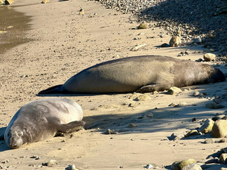


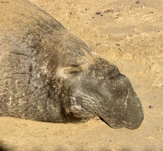


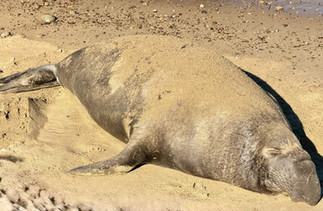

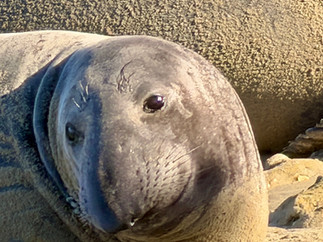
Chimney Rock Trail and cute elephant seals
Just a bit further down the beach we witnessed something very interesting. There were hundreds of pelicans swimming, flying, and feeding here. We saw a seal swimming along the shore amidst the pelicans. Surprisingly, the pelicans immediately all gathered and began flapping their wings and chasing the seal out of their feeding ground. Wow, who knew such thing happened along those beaches. We were in awe of these creatures and had a very hard time leaving the spectacle behind. But, as always, we must move on.


Pelicans chasing a seal
Next stop was a 20 minute drive to the Point Reyes Lighthouse. To reach the lighthouse, there are 313 steps down to it and 313 steps back up. It is well worth the huffing and puffing though as it really is beautiful. We did huff and puff up and down but there were younger folks attacking these stairs two steps at the time and barely breathing hard - oh to be young again. This place, we were told, is considered the windiest and the foggiest place along the entire west coast. The wind can reach up to 40 MPH. A sign also said that Point Reyes is the second foggiest place in North America after Grand Banks in Newfoundland which is number one. We are well aware of this as we experienced the thick fog in Newfoundland two summers ago. Lucky for us, today at Point Reyes it was beautiful and sunny. The sky was clear, and there was not a wisp of wind in the air. The Lighthouse was built in 1870 to warn ships heading towards San Francisco Bay about the rocks along the north coast. Unlike most lighthouses, which are built tall for visibility, Point Reyes Lighthouse is only 35 feet tall and stands on the very edge of a steep rocky cliff 265 feet above sea level. Mariners could see its light beneath the high thick fog that often cuts across these cliffs. In the 1906 San Francisco earthquake the lighthouse was shifted north by 18 feet along the San Andreas Fault, but suffered very little damage.


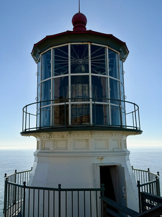
Point Reyes Lighthouse
Speaking of the 1906 San Francisco Earthquake, further down the road we did a short hike on the Earthquake Trail. This trail itself isn’t much but it was quite daunting to realize that we were actually walking directly on top of the San Andreas Fault Line. Along the trail there are a few informative panels explaining about the great San Francisco Earthquake of 1906. At one point we saw remnants of a fence that supposedly was pushed 16 feet high in the air as the ground split during the earthquake. There is also a row of posts painted blue placed in a line to give the visual of where the fault line actually is. On April 18, 1906, a 7.8 earthquake struck San Francisco along the San Andreas Fault at 5:13 am that lasted for 45 seconds. Up to 5,000 people died and 500 city blocks with 28,000 buildings were destroyed by the earthquake and the ensuing fires. It is estimated that between 227,000 - 300,000 people were left homeless out of a population of around 410,000.


Earthquake Trail
Our diversion to big cities continues. Today we travelled to San Francisco but only to see the Golden Gate Bridge - a long time dream on Guy’s bucket list. We find that big cities are too much of a challenge with trying to find the attractions we want to see, parking is often difficult, and walking with Treme along busy city blocks is also difficult. So we do our best to avoid cities whenever we can. Before entering San Francisco we were told to drive up to Hawk Hill which offers some of the most spectacular views of the Golden Gate Bridge. Hawk Hill is also a resting place for migrating hawks. We read that at one time there could be as many as 600 hawks on and around the hill. Well of course we were off season and saw none. One fun story here is, as we got out of the Roadtrek we discovered we were parked beside a car that was all wrapped up as a Christmas present with a Christmas tree and blinking lights laying flat on the roof. We had the pleasure of chatting with the owner and his friend. He said he had wrapped up the car in cellophane wrapping paper using regular scotch tape and he can only drive a maximum of 50 mph otherwise the car behind would end up wrapped. The Christmas tree is real and he felt he might need to water it soon as it is starting to get a bit dry. One of the guys had travelled from Saskatchewan through Calgary to Whistler with his father last year and he said they are already planning another upcoming trip. They were great fun. And, yes it is quickly getting close to Christmas - after all only two weeks away.

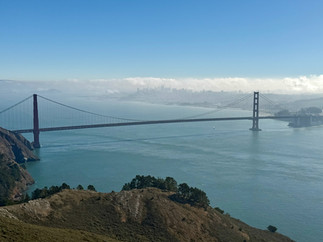


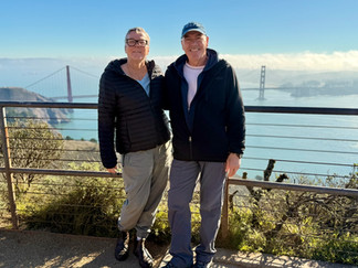


Views from Hawk Hill
From Hawk Hill we enjoyed some of the best unobstructed views of the Golden Gate Bridge, San Fransisco, and Alcatraz at a distance. After a slow drive circling Hawk Hill, it was time to drive across the bridge. To Guy’s delight, we slowly enjoyed driving across the bridge. What an amazing drive. Guy was totally impressed. On the other side we spent some time at the visitor center and park area. It was Saturday so it was quite crowded with people. Lucky for us the sun was shining and the views were spectacular and we enjoyed. We did learn tons of intersting facts and information about the bridge. The chief engineer of the Golden Gate Bridge was Joseph B. Strauss. Planning started in 1921 and the bridge was completed in 1937. Sadly the construction of this bridge took its toll on Strauss’ health and he died less then a year after its completion on May 16 1938. The two massive main suspension cables weighs approximately 24,500 tons with each cable made from thousands of individual steel wire strands bundled together, forming huge, strong structures that hold the bridge's deck. The length of each cable is 7,650 feet, 36 inches in diameter built from a total of 27,572 individual galvanized steel wires grouped into 61 strands in each cable. There is a total of 80,000 miles of wire used (enough to circle the earth three times). There are approximately 600,000 rivets in each tower, 83,000 tons of structural steel and it took a total of 1,605 days to build the bridge. The main span of the bridge is 4,200 feet and when it opened it was the world's tallest and longest single-span suspension bridge in the world. The bridge has flexibility and can sway up to 27.7 feet in the wind and is designed to withstand massive earthquakes. The colour of the bridge is called International Orange - consulting architect Irving F. Morrow chose this colour. Back in the 1930s, most bridges were painted black, aluminum silver, or gray, but Morrow felt these colours too common for a bridge of such magnificent grace. So he selected International Orange to emphasize the details of its avant-garde Art Deco styling while still contrasting with the colours of the surrounding area and to improve visibility in fog, although the Navy wanted it blue and yellow.


Driving across the GoldenGate Bridge


Golden Gate Bridge


Original paint brushes, tools, and rivets used on the construction of the bridge


Other foot diameter cable close up, formed with thousands of single strand wires


During construction of the bridge
And to end of our day we needed to empty and refill Roadie which cost us a total of $40usd to sani-dump and refill with fresh water, ouch! California you are expensive. We boondocked at a Casino just outside of San Francisco in Colma which is known as “City of Souls”. This small town with a population of around 1,600 has 17 cemeteries that hold over 1.5 million buried souls. It is said that the dead far outnumber the living here. The casino parking lot is surrounded by cemeteries front and back. Well at least it was a quiet spot to boondock, neighbours were not rowdy at all. We did a few neighbourhood walks here with Treme and came across a few interesting things. As mentioned we are surrounded by cemeteries, Chinese, Italian, Japanese, Catholic, etc, and the grounds are filled with simple and elaborate grave sites. In all our travels to different cemeteries, we have never come across a gravesite that has a “For Sale” sign - this is a first. Perhaps the sign should say, “For sale, used but like new condition”, too funny. Another interesting object here is the “Cemetery Worker’s Bell”. This bell used to hang in a tower in a cemetery. When the bell rang it signalled to the workers that there was an approaching funeral. The workers would quickly change into their formal uniform and participate and help with the funeral. Back in the days, pretty well all cemeteries had these bells. Now the most intriguing is “The Mystery Tombstone”. This is one of the oldest tombstones found here in Colma and marks the grave for a H.J. Hartnagle who died in 1875 at the age of 29 years old. This tombstone was originally located at the Odd Fellow Cemetery in San Francisco. Back in the 1930s, the courts decreed that all bodies in existing San Francisco cemeteries be removed. This was due primarily to the pressure of finding “prime real estate” for the growing population, plus many of the cemeteries were in need of repair, as well there was a concern for public health. Hartnagle's remains, along with many others, were transferred to a mass grave site at Odd Fellows Cemetery in Colma. During the transfer, the tombstone was somehow separated from the body. It may have accidentally fallen from a railroad car or may have been discarded as many tombstones were when San Francisco cemeteries were evicted. Individual tombstones were prohibited at these mass grave sites. Fast forward to 2001, H.J.Hartnagle’s tombstone was found near the Holy Cross Cemetery during construction that was happening in the area. It may never be known what exactly happened to the tombstone and it remains a mystery still.


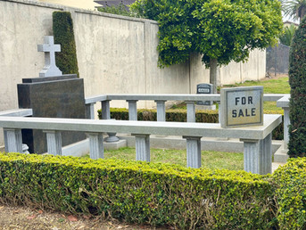

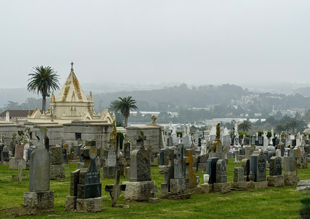


“City of Souls” Colma California
Here is a good way to end this blog: on a high note with the above quirky out of nowhere kinda of story. Sometimes we don’t have to search out these stories sometimes they just happen to find us. And we just roll with it….


Speaking of quirky stories that find us, Guy finally found a hairbrush that works for him.


Incredible write-up capturing your final months of 2025 on the West Coast. It was great meeting you at the top of Hawk Hill! Happy to report I made it through the season with no cellophane flying off! Hope you both had great holidays and enjoy the rest of your travels around the U.S. through April.
Best wishes,
Brennan