Blog # 17 - Yukon bound with a side of Alaska Part 2
- Pamela Sonier
- Oct 31, 2025
- 44 min read

We left Dawson City in the early morning to take the free 10 minute ferry across the Klondike River. Our destination was to drive on yet another long dirt road, the famous “Top of the World Highway”. This highway stretches for 106 kilometres from Dawson City Yukon to the Little Gold Creek US border crossing. And from there, on to Chicken Alaska and beyond.


Ferry across the Yukon River and start to the Top of the World Highway
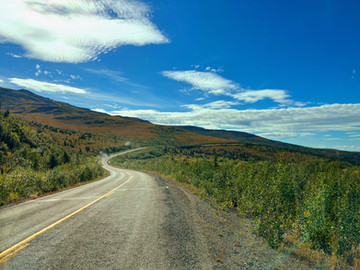
The Top of the World Highway was built in 1955 as a packing trail during the Gold Rush. It is very remote and extremely scenic and spectacular. The Top of the World Highway reaches its highest point at an elevation of 4,515 feet. The views along the entire road are just breathtaking and the beauty is almost indescribable. At each turn in the road we were rewarded with yet another awe moment - we really felt on top of the world. The road is built entirely so it travels from one mountain top to another by crossing saddle ridges, it never really goes down into valleys. We could continuously see the road stretching for miles ahead of us, snaking up and around from one mountain to another. Just as amazing is that, as per our previous dirt road experiences in the Yukon, we were expecting yet another horrific gravel road ladened with deep potholes and more, we were actually prepared for the possibility of a very slow and bumpy two day drive. But to our surprise we made it in just a few hours. The drive was really good, even smooth - smooth as far as a gravel road goes. Yet still, as smooth and good as it may have been, it was a bit daunting. It had no barriers of any kind on its edges and had very steep drops. It was at times, to say the least, a bit scary.


Top of the World Highway
We had been told that once we passed into the US, on the American side, the road was well paved. And it was. After crossing the border, we were on an excellent and beautiful paved road with defined shoulders and fresh painted lines down the middle. We were laughing and cheering as we both said “this is well worth the last 106 kms”. But, after only about 30 kms, the road changed drastically. It became dirt, narrow, winding, dusty, with very little to no shoulders, steep drops on the edges, many potholes, and many surface breaks for the remaining 58 kilometres all the way to Chicken Alaska - hard on the nerves and on Roadie. The town of Chicken, other than the adventure of driving the Top of the World Highway, was our other main draw to venturing this way. I mean who doesn’t want to visit a town called “Chicken” in Alaska.


Highway scenery
A quick history of Chicken. Like most places in the area, this town began with the discovery of gold back in 1886 when Bob Mathieson made a major gold discovery on Upper Chicken Creek. He staked his claim and it is believed that over 700 miners worked in that area between 1896 to 1898. By 1902 the population of Chicken soared to about 400 people and it is then that Chicken got its name. Now you may ask why Chicken? Well, that’s a fun story. The community applied for a Post Office in 1902 and they needed a name. There were many ptarmigans in the area so they were going to call the town Ptarmigan, but not everyone could agree on how to spell ptarmigan so they decided on “Chicken” as the ptarmigan looks similar to the chicken, and “Chicken” was way easier to spell and say. The ptarmigan did become Alaska’s state bird in 1955.


Welcome to Chicken Alaska!
In 1939, the F.E. Company started acquiring claims and built a camp on Nora Bench which is just outside Chicken and is now the location of the Chicken Gold Camp & Outpost. In 1953, they bought the town site of Chicken and turned it into a camp for their dredging operations. They moved the Pedro Dredge, which had mined on Pedro Creek just outside of Fairbanks from 1938 until 1959, to Chicken Creek where it operated from 1959 to 1967. In 1998, after it had sat idle for 31 years, the million pound dredge was moved in one piece to its present location at the Chicken Gold Camp & Outpost as a tourist attraction and was put on the National Register of Historic Places in 2006.


Pedro Dredge
Here in Chicken everything is chicken themed. Even the outdoor public toilets have chicken and rooster signs on their doors. There are chicken signs and chicken sculptures everywhere. One of the more interesting sculptures is “Eggee”. This metal statue is perched on a hill overlooking the Pedro Dredge at Chicken Gold Camp & Outpost and was created by high school students from recycled school lockers. It was presented to Chicken Gold Camp which sponsors the annual Chickenstock Music Festival.


Chickens, Chickens everywhere!
In the Summer the population of Chicken is between 12 to 15 people (not counting seasonal workers) and in the winter, after road closures, it drops down to 2. As Chicken is an unincorporated community it “officially” has no formal municipal government or mayor. We were told that the lady who runs the post office, and who along with her husband are the only two who live here year round, is somewhat considered the “unofficial” mayor of the town. Just outside of the “downtown”, there are 2 campgrounds. There are also 3 stores one of which is a gas station. There are no public telephones, no flush toilets, no sidewalks, and definitely no stoplights here. But what Chicken does have is a whole lot of good times, friendliness, character, and quirkiness.


Downtown Chicken
Downtown Chicken consists of three adjoining buildings: a gift store, a bar/saloon decorated what hats and bras, and a cafe with world renowned cinnamon buns. Unknowing of the bun sizes we bought two in the morning before they were even baked - that’s how fresh the were. We wondered about while these baked. The buns turned out to be amazingly big; they were so big we actually had to cut them into four portions. They were delicious and we enjoyed them for several days after leaving Chicken. While we waited for our buns we found out that the gentleman who runs the place had taken the business over from his mother. He was born here but had left to study in Paris France as a chef, and of course he spoke french, which Guy enjoyed. All three businesses are interconnected on the inside by doorways. The people working here work interchangeably between the three businesses. At the time we were in Chicken there were only 4 people left managing the 3 businesses. As this was nearing the end of the season, the other workers had left for the “Lower 48”. The lower 48 is a common term used in Alaska to describe the contiguous United States or any area outside of Alaska. We had boondocked for the night, along with a few other adventurous travellers, at the back of the buildings right in downtown Chicken. It was an unsurprisingly quiet and uneventful night in downtown Chicken.


Boondocking & Cinnamon buns
With our cinnamon buns in hand we travelled down the Taylor Highway, a rough but paved road, towards Delta Junction. While driving we were again greeted with beautiful sceneries. The Taylor Highway goes through some of the earliest and richest gold mining areas in Alaska. It is closed in the winter and the largest herd of caribou in Alaska cross this highway each fall on its annual migration - wish we could have seen that.
We stopped in Delta Junction at Historical Mile Marker 1422 which we discovered is actually the official end of the Alaska Highway. Contrary to our previous understanding, the highway from Delta to Fairbanks is called the Richardson Highway. The Richardson Highway, like the Top of the World Highway, was originally a packing trail in the late 1800s for gold seekers and later became the first major road into Alaska’s interior and Alaska’s first highway. This Highway existed long before the Alaska Highway was constructed and was the original connection from Fairbanks in the north to Valdez in the south. And it eventually connected Valdez to the rest of Alaska’s road system. It was upgraded over time and the section from Delta Junction to Fairbanks was incorporated into the Alaska Highway in 1942.


Taylor Highway & Delta Junction
Our original plan had been to head north from Delta Junction to Fairbanks and from there west to Denali and then south toward Anchorage and Valdez and eventually return to the Yukon. But as we have discovered on this trip our plans are continuously changing. In the Delta Junction visitor centre parking lot, we met a couple from California who were also travelling in a small van. After a bit of conversation they told us they had just traveled up the Richardson Highway and that the Denali Highway, both of which they described as beautiful and scenic. They did mention that the Denali Highway although a gravel road, was smooth and a “good” gravel road. From where we stood at Delta Junction, the views of the mountains looked majestic and beautiful on a clear day and we thought what the heck why not, let’s change our route direction again. We headed south on the Richardson Highway, across the Alaska Mountains Range, towards Valdez.


Richardson Highway sceneries
Along the Richardson Highway we had viewpoints of both the Alaska Mountain Range and the Wrangell Mountian Range. What beautiful sceneries. There were views of glacier, waterfalls, and even a few opportunities to see portions of the famous Trans-Alaska Pipeline. This pipeline connects the oil fields of Prudhoe Bay in northern Alaska to the harbour of Valdez in the south. The pipeline is 800 miles long and has a 48 inches diameter. It crosses 3 mountain ranges and over 500 rivers and streams. This is considered the largest privately funded construction project of all time. Construction of this pipeline began in 1975 and was completed in 1977 at a cost of $8 billion USD. The oil flows through this pipeline via 11 pump stations at a rate of 4 miles an hour and it takes 9 days for the oil to travel from Prudhoe Bay in the north to Valdez in the south. The first oil moved through the pipeline on June 20, 1977 and the first tanker to carry the crude oil from Valdez was the ARCO Juneau on August 1, 1977. It was interesting stopping along the way seeing this pipeline as it is one of those iconic things we had heard the name of for many years.


Richardson Highway scenery


Trans-Alaska Pipeline
After crossing the mountains on our way to Valdez we decided to again change direction and veered west to cross the Denali Highway towards Denali. This highway is said to be one of the most scenic drives in the world. It is a dirt road but we had just been told that it was very smooth so we decided we would venture it. This road is only open seasonally in the summer and closed in the winter and crosses Alaska east to west from Paxson to Cantwell. It is considers to be a good shortcut by many. We travelled about 60 kms and found out that this supposedly “good” gravel road is quite rough and difficult to travel on. Tired of being torturously bumped around, we stopped for the night at an absolutely stunning place on the side of the road where we boondocked and enjoyed the beautiful scenery. In the morning, not wanting to be bumped around anymore, we reluctantly decided to turn around, drive the 60 kms back, and head south towards Valdez on a good paved road. All this back and forth and mind changing sounds crazy but really that’s the beauty of this kind of travelling for so long: we can go anywhere we want at anytime we want. And we love it.


Denali Highway
Valdez greeted us with its rain, clouds, mountains, and of course mountainous sceneries. Valdez is a beautiful year-round ice-free port town located on a deep fjord in Prince William Sound in southeastern Alaska. It is surrounded by the snow capped Chugach Mountains which have the most frequently climbed mountains in Alaska. Here there are more then 60 of Alaska’s most accessible glaciers and one of the snowiest places on earth. Valdez felt exactly like what we thought Alaska would be. We decided to stay at a campsite right in the downtown. From here it was easy for us to wander around. Treme absolutely loved it here, there were rabbits everywhere for her to chase. These rabbits, probably originating from set-free domesticated rabbits, were wild and running everywhere.


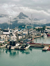


Valdez
Valdez was named by a Spanish explorer in 1790. During the winter of 1897-1898 Valdez was established as a gold rush boomtown. It had been advertised as an "All-American Route" from the ice-free Port of Valdez to the Klondike goldfields, promising an easier route than the one through Canada. Thousands of prospectors came to Valdez only to find the journey dangerous over the Valdez Glacier where many died from exhaustion, scurvy, and accidents. In 1899 the U.S. Army built a military trail which later developed into the Richardson Highway in 1910. Because of this route, Valdez was established as an important port for supplying the Alaska's interior. Over the years Valdez experienced many economic booms and busts and by the early 1960s the population had declined to about 600 people, one tenth of what it had been before World War I.


While here in Valdez we did see one of Peter Toth’s cravings from his “Trail of the Whispering Giants”. Peter Toth is an America Sculptor who along with his family fled Hungary during the 1956 uprising. The family lived in refugee camps for 2 years before immigrating to Akron Ohio in 1958. Peter Toth is known as a humanitarian artist. He embarked on a 20 year journey across America to create a Whispering Giant sculpture in each state to honour the Native Americans. He began his journey in 1971 and completed it in May of 1988 in Hawaii. In 1981, in Valdez, Peter Toth carved a Whispering Giant from a sitka spruce tree trunk. It stands 30 ft tall, 10 ft wide, and weighs 85,000 lbs. This sculpture represents the southeast Alaska tribes and the Headdress features four different faces. Guy thinks the sculpture looks like Willie Nelson, I gotta say I kind of agree.


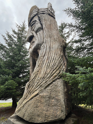


Whispering Giant
The two most prominent things we learned about Valdez are the earthquake and the oil spill. On March 27, 1964, on Good Friday the town of Valdez was devastated by a 9.2 magnitude earthquake which was the most powerful earthquake ever recorded in North America and has become known as the “Good Friday Earthquake”. The tremors caused a huge underwater landslide in Port Valdez which triggered tsunamis. In total 139 people died. Interestingly enough 15 died as a direct result of the earthquake and the other 124 died from the tsunamis that followed. Of those 124 people that died, 106 were from communities like Valdez and Chenega Alaska while 5 died in Oregon and 13 died in California.
The earthquake and tsunamis had completely destroyed the town of Valdez including the city's docks. The original townsite had been located at the foot of the Valdez Glacier and was found to be on unstable ground so the entire town was condemned and relocated four miles away to a more stable area. All the people still living in Valdez were given 2 years to pack up all their belongings and move 4 miles west to the newly created town of Valdez. By 1967 everyone including 52 buildings had moved to the new townsite. By 1970 all remaining structures in the Old Valdez townsite had been cleared.
The earthquake also damaged other communities in Prince William Sound. One of the hardest hit was Chenega, an Alutiq village which lost 23 of its 68 residents. The remaining survivors were displaced and it was not until the 1980s that they were relocated to their new village of Chenega Bay, on nearby Evans Island.
The Exxon Valdez oil spill is the other significant tragedy to happen here in Valdez. On March 24, 1989 which was again a Good Friday and 25 years after the earthquake - the oil tanker Exxon Valdez ran aground on Bligh Reef, 25 miles offshore. The captain wasn't at the helm when the tanker ran aground, he had left the bridge in the charge of an unlicensed third mate. The oil did not actually reach Valdez, but the spill caused one of North America's worst environmental disasters. The oil spill killed an estimated 250,000 seabirds, 2,800 sea otters, 300 harbour seals, and 22 killer whales. The sea otters and some seabirds, eventually recovered, but others did not. A pod of killer whales in the area saw their population decline up to 41%, and the commercial herring fishery in the Sound completely crashed and never fully recovered. The spill polluted over 1300 miles of Alaska’s coastline with 200 miles of that being heavily polluted.
Valdez became the operational center for the cleanup effort. Overnight, media, government officials, and workers arrived in Valdez. Within six weeks the population of Valdez went from 3,500 to about 12,000 people. Finding a place to stay here became difficult and many of the locals were renting beds in their homes for up to $100 a night. Exxon brought in portable ATCO trailer units for worker housing and a complex of offices that was nicknamed the"Exxon Hilton". Now, over 30 years after the initial spill, oil can still be found in some locations in Prince William Sound.
There are two museums here. One is the Old Town Valdez museum which has a detailed model of the town of Valdez as it was prior to the 1964 Earthquake. The other is the Valdez Museum which has stories, pictures, and artifacts from both the earthquake and the oil spill disasters; it also has information about the Trans Alaskan Pipeline, history of the gold rush, and information about the native culture in the area. An interesting story is about the first barrel of oil to be filled here in Valdez. The barrel is on display at the museum. This first barrel was actually filled with crude oil pumped through the Trans-Alaska Pipeline System originating from over 800 miles away in Prudhoe Bay and and arrived at the Valdez Marine Terminal on July 28, 1977.


Also very interesting was the story with pictures of Fairbanks dog musher Richard “Red” Olsen along with Randy his 14 year old son and their team of huskies. Over a year before the Alaska pipeline was completed, the father and son team brought a full barrel of oil to Valdez all the way from Prudhoe Bay on a specially built dog sled. This challenge was a fundraiser to help build a new fire station in Fox, Alaska. The team left Prudhoe Bay on February 23, 1975 with a 42-gallon barrel of crude oil. They encountered harsh weather along the way and had to change their route a few times which made them travel an extra 300 miles farther than they originally planned. They made it to Valdez on Sunday April 13, 1975. The trip was approximately eleven hundred miles, and took them 49 days. The team had also brought a bag of mail to Valdez, and when they arrived the post office opened to post mark the mail and it was the only time in its history that the post office was opened on a Sunday.


Musher Richard Olsen bringing first barrel of crude to Valdez
One other interesting story starts on October 4, 1980 when the Holland-America cruise ship the Prinsendam caught fire. The fire began in the engine room at around 1:00 am and by 3:45 am had filled the lower decks. The ship had 324 passengers and 200 crew members onboard. By 6:30 am all the passengers and crew members had abandoned ship and crammed themselves into lifeboats, many of which were beyond their maximum capacity. The US Coast Guard, the Canadian Air Force, and 2 nearby oil tankers, the Williamsburgh and the SOHIO Intrepid, quickly came to their rescue. The rescue took over 13 hours and astonishingly there was not a single death or serious injury. The oil tanker Williamsburgh brought 370 survivors into Valdez in Lifeboat #4 which is now on display outside the museum. A sad story but with a happy ending.


Lifeboat #4
After Valdez we travelled towards Anchorage and again we were greeted with more beautiful Alaskan sceneries. It was still rainy and foggy but by now we have become accustomed to this wetness. Along the way we made a quick stop at the St. Nicholas Orthodox Church in Eklutna to see the Burial Spirit Houses. Russian Orthodox missionaries arrived in this area around 1830 and built the St. Nicholas Church. The church was reconstructed in 1970 and has been in use for more than 150 years. The Eklutna people, who are part of the Dena'ina Athabascan group, began converting to the Russian Orthodox faith in the 1800s following the arrival of the Russian Orthodox Missionaries. Rather than replacing all indigenous beliefs, the Orthodox church incorporated some of the Dena'ina customs. These small Spirit Houses are a combination of the Dena'ina tradition of building shelters for the departed spirit with the Orthodox practice of burial of the dead. The customs at this cemetery are a blend of both of these cultures. A blanket is placed over a grave after burial to comfort the soul, and then 40 days later, a spirit house is added to provide the spirit shelter. In keeping with Dena'ina tradition, the houses are left to naturally decay. There are over 100 colourful and a bit unusual burial sites here. Most of these are the size of large dollhouses. It was very interesting walking in this cemetery as some of the Spirit Houses are larger with 2 levels, some even have porches and intricate doors and windows. Many of these bright coloured Spirit Houses emerge out of the overgrown foliage. There is a feeling of deep solitude here, yet a beautiful sense of peace.


St. Nicholas Orthodox Church and Spirit Houses
Our visit in Anchorage was short. We didn’t care much for the city vibe on that day so we decided to do only a few quick stops. We visited the Rondy Festival Headquarters & Dog Mushing Hall of Fame where we talked with a man inside who was very passionate about the dog races, dogs, participants, and everything else regarding dog racing. It was quite interesting. Just outside the door is where each year the ceremonial start of the Iditarod race begins. Also just outside a bronze statue that shows a sled dog in motion to honour all sled dogs. In Anchorage we also visited Earthquake Park which is the site of the former Turnagain Heights neighborhood. Hundreds of homes were destroyed here as they slid into the ocean when a massive landslide caused by the March 27, 1964 “Good Friday Earthquake” hit the area. Some of the largest buildings in the city including JC Penney, were demolished Tsunamis that followed the earthquake caused waves up to 20 stories high. The neighbourhood was never rebuilt instead they developed the park as a reminder of the devastation of what happened here.


Ceremonial Start of the Iditarod - Anchorage


Earthquake Park - Anchorage
On the lighter side, we visited what is believed to be the World’s Largest Chocolate Waterfall at the Alaska Wild Berry Shop. This water fall was built in 1996 and is 20 feet tall. It contains over 3,400 pounds of real liquid chocolate that has been donated by Nestle Foods & Guittard Chocolate company. The waterfall consists of a series of copper melting pots that spill liquid chocolate into one another. It was an interesting site to visits, especially for Guy with his sweet tooth, or should I say “sweet teeth”.


World’s Largest Chocolate Waterfall
We left Anchorage early the next morning after spending a bit of a noisy night boondocking in the Bass Pro Shop parking lot. We can’t really complain though as this is just the reality of free boondocking in cities. We left heading south traveling along the Seward Highway towards Whittier - another of these beautiful scenic Alaskan drives. The sceneries in Alaska are never ending. Along the way, as luck would have it, we were driving along enjoying the views when Roadie started making a loud screeching noise on the front right side. Guy recognized the sound and said it sounded like a stone rubbing against the brake disk. We stopped in a parking lot. Unfortunately after exploration, Guy could not see a quick fix to the problem and decided he had to take the entire wheel off. Guy did his thing. He got his tools, jacked up the van, removed the wheel, looked behind and found the problem. A small pebble had got stuck against the brake disk. It was quickly removed and the wheel replaced. I was very impressed with my man and we continued our way to Whittier.


Seward Highway
One of the many appeals of traveling to Whittier, a small town at the edge of a water passage to the ocean, is going through the Anton Anderson Memorial Tunnel. This one lane tunnel connects Portage Alaska (which is now considered a ghost town due to the extensive damage caused by the 1964 “Good Friday earthquake”) with the town of Whittier. This tunnel is the only land access to Whittier. The tunnel was built underneath the Maynard Mountain and it is the longest highway tunnel (2½ miles long) in North America and is also one of a few to service both rail cars and automobiles. The passage was constructed by the military during World War II as the Alaska's main supply route for goods arriving in the port in Whittier. When the military left Whittier in the 1960s, the tunnel was made a part of the Alaska highway and was upgraded and opened to vehicle traffic in 2000. The tunnel has a single lane which is shared by both vehicles and the Alaska Railroad. The traffic moves in one direction at the time on the half-hour. All vehicle traffic stop when the train arrives. While waiting our turn to go through the tunnel we were able to relax and enjoy the breathtaking scenery around us.


Whittier Tunnel
Whittier was established in World War II as a military supply post named Camp Sullivan which operated from 1943 to 1960. At the start of the Cold War the U.S. military decided to expand its presence in Whittier. They constructed two large buildings designed to house over 1000 personnel. The six story Buckner Building was completed in 1953 for the soldiers and their families to stay in. There was a church, bakery, commissary, kitchen, a hospital, a 320-seat theatre, a 4-lane bowling alley, a 6-cell jail, a church, library, radio station, rifle range, photo lab, even an officers' lounge. The building was abandoned after the military ran out of uses for it, and in 1964 the “Good Friday Earthquake” made the building unstable and no longer safe to enter. The building now sits upon the mountain side abandoned. We were not allowed to go into the building but we could walk up and around it. It certainly seems quite desolate hard to imagine how much life it had held back when this was fully functional.


Abandoned Buckner Building
The second building here “The Hodge” was considered to be the largest building in Alaska at the time. The construction began in 1949 and the building was completed by early 1954 at a cost of over $6 million dollars. There was over 273,660 square feet of floor space and it was described as “a city under one roof”. It was originally called “The Hodge” but today it is known as the Begich Towers. This 14 story tall building was built in seven sections with each section separated by 8 inch gaps. All the sections were connected through wide stairwells and elevators. This design was to give the structure the flexibility to ride out earthquakes (which it did in the Good Friday Earthquake of 1964). The military's presence in Whittier ended in 1960 and in 1969 Whittier was officially incorporated as a city.


Begich Towers where the majority of the population of Whittier live
We did wander around Whittier for a bit. It really is a quaint and beautiful secluded little town. There are a few artisan stores selling souvenirs and coffee to tourists. Also a few restaurants. The town and port area are very picturesque. Whittier is located on the Kenai Peninsula at the head of Passage Canal, which is part of Prince William Sound, it is surrounded by mountains and glaciers.


Whittier
We travelled back through the tunnel, pass Anchorage, toward Knik where we stopped to visit the Musher’s Hall of Fame. The area is sometimes referred to as the "Dog Mushing Center of the World," as it was home to many famous mushers and still is today. A musher is the person operating a dog and sled team. The Museum is located in one of the two original buildings left here in Knik. On the main floor there are many artifacts from the history of the area. The second floor is where there are painted, charcoal, and drawn portraits of some of the famous mushers like George Attla, Rick Swenson and there are photos of dogs, mushers, and a selection of different trophies including the Red Lantern.


Mushers Hall of Fame
The story of the Red Lantern is very interesting. The Red Lantern Award originally began as a joke in 1953 during the Fur Rendezvous Race - another race held here in Anchorage Alaska. The lantern was given as a looser trophy to the racer finishing last. When the Iditarod started in 1973, it changed the practice of giving a Red Lantern as a joke. Instead, they now gave the red lantern to the musher finishing last as a symbol of determination and tenacity. At the start of the race each year the Iditarod Trail Committee light a Red Lantern in Nome Alaska which is where the race ends. The lantern stays lit until the final musher crosses the finish line. It is believed this practice came from the days of the Gold Rush when dog sled teams were used to move freight and mail. Each roadhouse along the trail would light a kerosene lamp and hang it outside to help the mushers find their way in the snow and darkness. It was also a signal that there was a dog team on the trail. The lamp was extinguished when the dog team safely reached its destination.


The Red Lantern
Just down the road from the Musher’s Hall of Fame museum is the start of the Iditarod National Historic Trail. This trail was originally used by the First Nations Peoples and also during the Gold Rush. It is believed that millions of dollars in gold were transported along this trail by dog teams. A part of this trail was also used by mushers to bring the Diphtheria Serum to Nome in 1925. As we were standing outside talking with the gentleman who worked in the museum we began to hear this loud usual sound. We looked around wondering what it was and we were told “oh that’s just the dogs next door in the kennels”. The sound was a combination of probably over 50 dogs barking all at the same time, we have never heard a sound like that before. A bit eerie but very interesting we must say.


Outside The Musher Hall of Fame - Knik
Just 19 kms from Knik is Wasilla where the Iditarod Headquarters is located. There are many trophies, memorabilia, signed posters, portraits, photographs, dog statues, and taxidermy on display here. The museum offered a short video documentary with a wealth of information and insight about the Iditarod dogs and the mushers. The best part about the video was how the mushers treat their dogs. The dogs are treated like athletes. They consume only the best of food. Plus, The mushers have such a high respect for the breed, I found this refreshing to hear. In the movie one musher said what he learnt from his dogs was to always just live in the moment. He was explaining this in regard to the race, that the dogs do not worry about the curve ahead on the trail or the curve behind them they are just focused on the curve they are in now. Words to live by, I think.


Outside the Iditarod Headquarters
In the museum is a taxidermy of “Togo”. Togo was a small dog compared to the other dogs.
When Togo was 8 months he became Leonard Seppala’s lead dog. Leonhard Seppala was a famous Norwegian-Kven-American sled dog musher, trainer, and breeder. Togo led Seppala’s teams to many championships. In 1925 Togo led Leonhard Seppala and his dog team in The 1925 Serum Run, also known as the Great Race of Mercy. This relay race was created to transport an antitoxin for diphtheria by dog sled across Alaska by 20 mushers and about 150 sled dogs. The race which was 1,085 km long and took in 5½ days was designed to save the small town of Nome and the surrounding communities from developing an epidemic of diphtheria. Balto was the lead sled dog on the final stretch of the race into Nome, and became the most famous canine celebrity of that time. But it is Togo’s team who ran most of the dangerous parts of the route and also ran the farthest: Togo's team covered 420 km while Balto's team ran 89 km. After this run, Togo was permanently injured and could no longer race. He then retired to a kennel in Maine and lived a easy going life until he passed away on December 5, 1929.


Leonard Seppala & Togo
There are quite a few different dog sled races in both the Yukon and Alaska and of course with me anything “dog” I am on it. Poor Guy has just had to come to terms with it, he comes along for the ride, so to speak. As previously mentioned, outside of Anchorage in Willow is where they start the famous Iditarod Dog Sled Race. This race is held the first Saturday in March each year and travels from Anchorage to Nome Alaska for a total of approximately 1600 kms, depending on which route. There are two routes for this race and each one covers sections of the 1910 mail route. The routes alternate each year in order to reduce damage to the trails. This race began in 1973 as an event to test the best sled dog mushers. Joe Remington Sr who is considered the “father of the Iditarod” for his work in promoting the race, was born in Oklahoma in 1917. After serving in the Army during WWII he moved to Alaska in 1948 to homestead. He started the Knik Kennels and until 1966 he and his dog teams did search-and-rescue work for the army. He had two reasons for organizing the long-distance Iditarod Race: to save the sled dog culture and the Alaskan Huskies and to preserve the historical Iditarod Trail between Seward and Nome. In 1970 Joe mushed a dog team to the summit of Mount McKinley to show to the world what dogs can do. Joe competed in seventeen Iditarods from 1974 to 1997, but he never placed higher than 5th-place which he did at the age 72.


Iditarod Headquarters
Now there is a load more of information and interesting facts regarding these races so we won’t go into it much deeper but we thought we would share just a couple more interesting facts:
The sled dogs need to consume between 10,000 and 12,000 calories per day while on the race.
There are a total of 26 checkpoints along the trail and the dogs are fed at each checkpoint.
The dogs wear booties and the drivers are required to have at least 8 extra pair of booties per dog.
There is a Rule 42 which is “Expired Dog”. Any dog that expires (dies) on the trail must be taken by the musher to a checkpoint. The musher may transport the dog to either the checkpoint he just passed, or the upcoming checkpoint.
If a dog is injured and unable to continue the run, the musher lays him on top of the sled to rest until the next checkpoint.
The oldest person to win was Col. Norman Vaughn, who was 87.
Rick Swenson is the only person to ever win the Iditarod five times.
The fastest time was recorded at 8 days 14 hours and 19 minutes.
The slowest time recorded was 32 days in the early days, now it’s about 13 days.
A ceremonial start of the race is in Anchorage and this is followed by the official “restart” in Willow, a city which is 129 km north of Anchorage. The restart was originally in Wasilla until 2002 but due to little snow fall it has been moved to Willow since 2004.
While here at the Headquarters we also had the opportunity to go for a bit of a sled dog ride. Riley Dyche is a musher who has competed in both the Iditarod and Yukon Quest dog sled races. He brings some of his dogs here and offers visitors a ride around a short trail through the trees during the summer months. Riley has smartly created a custom made sled on wheels, more or less a small wagon with seats on wheels. While he is amusing tourists, he does this most importantly to keep his dogs in shape by exercising them, and of course this is how he make a few additional dollars in the off season. It was a fun thing to do. The dogs ran much faster then we thought. And there was one sharp turn where Riley gave us the heads up to lean to the right to counterbalance the weight or we would basically fall out or worse tip over. Afterwards we were able to spend some time with the dogs giving ear and belly rubs.


Hanging out with the sled dogs
Leaving the dogs behind we started our way towards Denali State Park. And it finally happened! After all this time and distance traveled we got to see a moose up close. We have seen a few moose but never this close. She was literally just standing on the side of the highway munching on leaves. We had the pleasure to stop and watch her. When I rolled down my window we were close enough that we could hear her munch on plants and leaves. Interestingly, she was just eating the top portion of the branches, this way she did not have to bend all the way down. We have been wanting to see moose up close since we started this trip 18 months ago. Always in a good way of course, not jumping out of a ditch and on the road in front of our Roadtrek. Finally, our wish came true. What an absolutely beautiful creature she was.


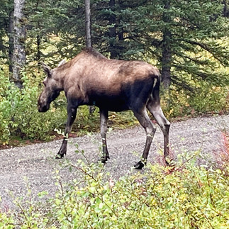
Our Moose!
We decided to book a campsite in Denali, just outside the Denali State Park, we needed showers and wanted hookups and WiFi. Lucky for us our neighbours were a wonderful couple from Switzerland; Brigitte and Beni. Guy befriended them first as they spoke French and I think all three of them were happy to speak their language. Also to Guy’s delight Brigitte had what seemed to be an endless supply of Swiss Chocolate which she kept sharing. She wanted to get rid of them, she said, before they travelled back home. Luckily for us we would meet up again with them a few more times in Alaska.


Scenery on the highway to Denali State Park
It had been rainy and foggy for a few days now, but we decided we would spend time in Denali State Park exploring a few hikes and hoping to catch a glimpse of Mt Denali. Unfortunately for us Denali was shrouded in clouds, but still we could feel her presence. Mother Nature is so unpredictable at times. How we wished we could have seen such a majestic mountain. We did see a few moose grazing in the distance. Well we did not catch a glimpse of the mountain but we did learn the very interesting and complicated history of its name/names. Mount McKinley formerly called Mount Denali stands 20,237 feet above sea level. This mountain has been renamed numerous times over the years due to politics disputes. The Native Koyukon Athabaskan peoples originally called the mountian “Denali” which means “The Great One” or “The High One”. On example of the political influence in the mountain’s name dispute goes as such: in 1896 a gold prospector named William Dickey assisted in the renaming the mountain to "Mount McKinley" after a presidential candidate from Ohio William McKinley. Interestingly enough McKinley never visited Alaska nor had any connection to the mountain. William Dickey was a proponent of the “gold standard” which McKinley also supported. The gold standard is a monetary system where a country's currency is directly tied to a fixed quantity of gold. This system has now been replaced by "fiat money" since the 1970s. Fiat currency is government-issued money that is not backed by a physical commodity like gold or silver, its value comes from the government's authority and the public's trust in that government to honour it as legal tender. Now many prospectors in the area were mining silver as well so they were more in favour of the “silver standard” which Mckinley’s opponent in the presidential race supported. So there was quite a bit of bickering and back and forth. In 1901 William McKinley was assassinated and the name Mckinley gained popularity for the mountain. As a result, naming the mountain “Mount Mckinley” was officially adopted by the federal government in 1917. For many years Alaska officials and Native organizations petitioned the federal government to restore the name to Mount Denali. The state of Alaska changed the mountain's name back to Denali at the state level in 1975, but Ohio representatives (where Mckinley was from) repeatedly blocked efforts to make the change federally. In August 2015, the name officially changed to Denali on the federal level and in January 2025 the name was changed back to Mount Mckinley. The state of Alaska and many Alaskans still continue to use the name Denali. This mountain even has a nickname "Mount Mid-Life Crisis" by some climbers.


Picturesque Denali State Park in the fall
We did a quick stop in Healy on our way towards Fairbanks to check out the bus from the movie “Into The Wild”. We had both read the book by Jon Krakauer and watched the movie and became intrigued with this story. A Replica Bus sits in the courtyard of a brewery in Healy. I had read that the “original” bus was now located at the the University of Alaska Museum of the North in Fairbanks. We were quite excited to go and see it but as things sometimes go, not everything goes as planned. In June 2020 the bus was located to the University where it is being fully restored and will be on permanent display “soon”. So no, we never saw it.


Replica Bus
Still the story is interesting. Originally this was a city transit bus in Fairbanks, it was retired from public service around 1959. The Yutan Construction Company purchased the bus to use as temporary housing for the workers who were working on an access road between the Alaska Railroad and a nearby mine. The bus was left behind in the summer of 1961 after an axle broke, leaving it permanently stationary at the northern end of Denali National Park along the Stampede Trail. The closest town was almost 30 miles away. Over the years the bus has served as an emergency shelter for hunters and other backcountry travellers.
Christopher McCandless was an American adventurer who lived in the bus for 113 days before he died of starvation in 1992 at the age of 24 years old. He was trapped on one side of the river as the water rose. His story is told in the book and movie "Into the Wild”. Because of the popularity of the book and movie, where the bus was located turned into a pilgrimage site for adventurers. Getting to the bus was quite difficult and dangerous. Two people have died trying to reach the bus and many tourists looking for the bus have become lost. Between 2009 to 2017 there were 15 bus-related search and rescue operations by the state of Alaska so in 2020. Because of this, it was removed via helicopter by the Alaska Army National Guard to the University of Alaska Museum of the North to prevent further tragedies. The final result is, we became well informed about the bus but never got to see it.


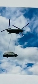
The original Bus and Original Bus being relocated via helicopter
We spent a bit of time in Fairbanks and saw a few things. The Moose Antler Arch was built in 2010 and some claim it to be the "World's Farthest North Antler Arch.” The arch represents cultural significance and history of game hunting in the area. This arch has over 100 antlers of different types all woven together. Mainly, the antlers are from moose and caribou donated by hunters and farmers across the interior of Alaska.


Moose Antler Arch
Here in Fairbanks is the Yukon Quest Headquarters, another famous dog sled race. The Yukon Quest is a historic 1600-kilometre sled dog race between Fairbanks Alaska and Whitehorse in the Yukon. It follows the historic routes taken by gold rush prospectors and mail carriers during the Klondike era. This particular race was conceived in 1983 by four Alaskan Mushers who wanted to create a sled dog race with more focus on wilderness survival skills than the Iditarod. The route is known for being one of the most difficult sled dog races in the world because there is limited support for the mushers, there are less checkpoints between and they travel over many frozen rivers, across four mountain ranges, and endure the cold temperatures and high winds. Unfortunately due to disagreements between the Canadian and American organizers, mostly over mandatory rest times for the dogs which the Canadian organizers wanted to increase, no agreement was reached and with the COVID- 19 Pandemic each the Canadians and the Americans began organizing separate shorter races. The historic Yukon Quest cross-border race has not happened since 2020. The museum again was interesting to explore with photos, artifacts autographed posters, statues constructed from legos, and learning about the race’s interesting history.


Yukon Quest Headquarters
There is an Alaska Highway Milepost 1523 in Fairbanks which stands at the “unofficial” end of a highway. We now know that the “official” end of the Alaska Highway is in Delta Junction which is about 152 kms southeast of Fairbanks. Nonetheless we still had to check it out and take the photo while we were here.


The “unofficial” end of the Alaska Highway
Also here in Fairbanks is the Lend-Lease Monument. This monument features bronze statues of an American and a Russian pilot to honour the U.S. Lend-Lease program. The monument also stands to recognize that Alaska was an important part of the America-Siberia Airway program during WWII. President Roosevelt introduced the Lend-Lease program in 1940 as a way of lending rather then selling military supplies to Great Britain for their fight against the Germans. This eventually expanded and included other Allied countries like China and Russia. The monument specifically recognizes the air route used to transport aircraft to the Soviet Union between 1942 to 1945. Over 8000 aircraft passed through Ladd Field, the military airfield in Fairbanks, on their way to the Russian front. At the back of the monument there is a depiction of the route these pilots flew. The route began with U.S. ferry pilots picking up aircraft from all across the U.S. and delivering them to a staging base in Great Falls, Montana. From Montana, U.S. Army pilots flew the planes through a network of airfields called “The Northwest Staging Route” which ran through Alberta, British Columbia, Yukon, and Alaska with Fairbanks being the major hub. The route connected to the ALSIB (Alaska-Siberia) route, which was the Soviet portion. The U.S. pilots would deliver the aircraft to Ladd Field in Fairbanks where the planes were inspected and serviced before being officially transferred to Soviet pilots. Once approved Soviet pilots would take over and fly the aircraft across the Bering Strait into Siberia. The airplanes had been lent to the Russians for free. Sadly many of the pilots and the planes never returned home. The Lend-Lease Program ended in September 1945 as the war was over and the program was no longer needed. Such war stories are very interesting.


The Lend-Lease Monument
We made a stop in North Pole Alaska just south of Fairbanks. This town was originally called Davis. It was renamed North Pole by the Dahl & Gaske Development Company; they had bought the Davis homestead in 1952 and subdivided it as a marketing ploy to attract a toy manufacturer hoping that the factory could then advertise that its toys “were made in The North Pole”. Unfortunately no toy company located here but the name stuck. Now this was such a fun stop. The street lights poles are wrapped and decorated as candy canes, there are year round Christmas decorations and lights, and the streets have Christmas themed names like Candy Cane Drive, and Santa Clause Drive. Everything here is Christmas themed. Having the Christmas spirit every day is just a lot of fun!
Also located here in The North Pole is The Santa Claus House. This is an 18,000 square feet building with 9,000 square feet of it is completely a Christmas-themed store. In 1952 Con & Nellie Miller left Fairbanks and started their new trading store in North Pole. Before this they had a trading company in Fairbanks back in 1949 where Con would go to the native villages with merchandise and trade for furs and other items they had. When Christmas came along he would go to the villages dressed up as Santa Claus for the local children. The kids all knew who he was but kept calling him Santa. One day when Con and his son were building the new store one of the kids from one of the villages was passing by in a truck and asked him “What are you doing Santa, building a new house?”. This gave Con an idea and The Santa Claus House was born. The store was located between two military installations and right in the middle of the new town of North Pole so the store became a bit of a gathering place for the locals. Nellie Miller was also the postmistress so the store became the post office as well and was The North Pole's first Post Office. Locals would come to buy groceries, socialize, or pick up their daily mail. Eventually the store began selling Christmas items. Con became North Pole's mayor, his wife Nellie was a marriage commissioner. She married thousands of couples in the Santa Claus House. The Millers became known as Mr. and Mrs. Claus and when their daughter was born, they named her Merry Christmas Miller. This store is full of Christmas things. There are many different theme decorated trees, Santa Clauses, ornaments, toys for kids, toys for adults, and even toys for pets. There are Christmas themed T-shirts, hats, socks, you name it it’s here. Behind glass there is a display of Santa’s Workshop. There are letters to Santa posted everywhere and even two mailboxes where you can drop off mail and get the “North Pole” postmark. One is for the “regular” mail and the other mailbox is where you can drop your mail that will be delivered at Christmas. Loads of fun.


North Pole Alaska & the Santa Claus House
While at the Santa Claus House we again met up with Brigitte and Beni the couple from Switzerland whom we had previously met in the Denali campground. We had wanted to stay outside of Fairbanks. We had checked the northern light forecast and tonight was the best night to see them. As Brigitte and Beni were also wanting to boondock, we recommended a place we had found on our iOverlander App. The Chena Lakes Campground which happened to be closed for the season so it was free with beautiful big sites and of course pit toilets. When we arrived we had the entire campground to ourselves. Brigitte and Beni set up camp adjacent to us and we had interesting conversation, enjoyed some wine, and more delicous Swiss chocolate. They had also been in Valdez, and Beni as it turned out is quite a fisherman. They told us he had caught quite a few salmon and they had them professionally cleaned and prepared and would be taking them back to Switzerland - a perfect souvenir from Alaska. We all did get up in the middle of the night to see the northern lights. Sadly we only faintly saw them; they were not that strong. Still a wonderful way to spend our last night in Alaska.


Our last night in Alaska - Northern Lights
The next day we started our travel south towards the Canadian border. A long the way Mount Denali did peek out of the clouds momentarily to allowed us a quick glimpse of its majestic snow top. We had an interesting day meeting people at rest stops along the road. There always seems to be a mix of interesting people with interesting stories traveling these roads. We met a sweet young couple from South Carolina. They were relocating to Fairbanks for a 3 year contract. He, as it turned out was an army radio/computer electronic specialist, and she a chemotherapy pharmacist. They travelled in their little car with three dogs on board. They told us how very excited they were to experience snow for the first time ever. I wonder if after their first winter in Alaska they will still feel this same excitement. While talking he kept describing the roads as wavy. I told him if he is coming north he needs to learn the road lingo, these are called “frost heaves not waves”. I told them about my friend Keitha and her husband who lived here in Alaska and had volunteered with the Iditarod race (which I only just discovered) and they were quite excited about the possibility of maybe getting the opportunity to do this while staying here. It’s amazing how the world just rotates round and round and we wander through it, learning and teaching. We met another guy at a different rest stop who is also moving to Alaska but to Anchorage. He is a heavy duty helicopter mechanic, a civilian not military, and would be starting his new job in just a few days. He was just sitting on the roof of his car enjoying the sunshine and eating lunch, enjoying his journey. Apparently he had slept in a small cot beside his car that night.


A quick peek at Mount Denali heading down the highway
We were told again and again that the road from the border of Alaska/Yukon just outside Beaver Creek down through Burwash Landing, through Destruction Bay, to Haines Junction was very rough, potholed, and even dangerous in some places. Not sure but maybe it’s because of all the other dirt roads we have traveled on but we did not find this one so bad. A stretch of about 10 kms under construction was quite rough but otherwise not a bad road at all. May be it’s because we drive slower than others? Either way, our motto remains “keep expectations low and you may be pleasantly surprised and hardly ever disappointed”


Traveling the ALCAN to the Yukon
And now our time traveling the whole of the Alaska Highway has come to a completion. We started at the 0 mile marker of the ALCAN in Dawson Creek BC. We travelled the entirety of the highway and stopped at many of the historic markers along the way and it seems fitting that our last Historic Marker be 1061 - Soldiers Summit. This summit is not at the beginning of the highway nor is it at the end, it is in between. It is where the highway construction crew coming from Dawson Creek met the Delta Junction construction crew making this place the completion of the Alaska Highway. On November 24, 1942 there was a ribbon cutting ceremony here to officially open the highway. Both the Canadians and the Americans were here on a hill overlooking the Kluane Lake. How fitting of a place, Kluane Lake is beautiful. We must admit though that the two standing flag poles have seen better days, they are a bit weather tattered and could use a bit of tender loving care - just saying.


Soldiers Summit
A while ago, when travelling the highway from Haines Alaska to Haines Junction in the Yukon, this before venturing deep into the Yukon and Alaska, we had said it would be nice to drive this road again for all its beauty. Well here we are back at Haines Junction, we have made the full circle. We have travel the entirety of the ARCAN to return here. And, we decided to head south and redo the Haines Highway. We drove down to the American border and back up again to Haines Junction, approximately a 200 kms detour. Again we saw the beauty of this drive. It was a beautiful way to spend a day. There is hardly any traffic on this road so we were able to relax and again fully enjoy.


One more time down the Haines Highway and a wonderful night boondocking
After the Haines Highway we returned to Whitehorse, our base, to replenish before our next adventure continuing south. We decided we would drive The Stewart-Cassiar Highway on our way towards Kamloops. We were told this highway was very scenic and it did not disappoint. The highway runs through both the Skeena Mountain Range and the Cassiar Mountain Range. With much less traffic than the ALCAN highway our pace of travel was much slower and more relaxed and enjoyable. The first part of the highway was a bit unnerving. It was very narrow with many sharp curves and hills. But we soon settled and enjoyed the movement and energy of the road as it winded around lakes, fields, mountains, ice-fields, and waterfalls. We camped our first night at Jade City - population of approximately 20. This was a must stop for Guy. For a few years he has watched a reality show on TV called “Jade Fever”. This is a show about a family base company who mines jade out of the mountains in this area. Jade City is their home base. Guy was quite excited about being here. On site there is the family-run Cassiar Mountain Jade Store with a small motel and a free campsite where we spent the night. There are huge amounts of jade deposits in the area - hence the name. Outside the store there are large jade boulders lining up the road and inside there are many beautiful jade carvings and jewelry. Definitely not inexpensive but fun to check out. Guy did buy a small jade ring. We spent a quiet night here and left in the early morning going deeper south.


Stewart-Cassiar Highway


Jade City B.C.
Stewart BC is a quaint little town tucked away in a corner of Northern BC. It is a small and isolated place with an interesting story attached. Stewart was established in 1902 as a mining town and at one point boomed with a population was over 10,000. But soon, with many of the men having to go to war and the crash of the stock market following, the population dropped to under 100. Today the population is approximately 500 people. Stewart is somewhat of an eccentric little town. The Visitor Center is only open from 1 pm to 4 pm daily except on Saturdays and Sundays of course. There are two bakeries/cafes with limited hours of operation as well. And we were told there is a “sometimes not open at all really good Mexican Restaurant”, which of course was not open on the day we were there. The town also has one very interesting museum, two grocery stores, one laundromat, two hotels, two campgrounds, free roaming chickens and roosters, and numerous signs warning about bears - a reminder for everyone to always be “bear aware”.


Bear Glacier on the way to Stewart B.C.


Stewart B.C.
Our main reasons to visit this area, other then the surrounding mountainous beauty and the appeal of this unique little town, was to see the bears feeding on salmon in the river and to drive up to the famous Salmon Glacier. On our second day here we drove from Stewart to cross the wide open US border into Hyder Alaska, there is no customs here. Just a bit further up the road we stopped at the Fish Creek Wildlife Observation Site to see the bears. After crossing the entrance gates we walked along a bear proof 600-foot-long elevated platform located between Fish Creek and Mark's Creek to catch a glimpse of bears fishing for salmon. When we first arrived on site the smell in the air of rotting fish was overpowering. There were hundreds of dead and dying salmon laying everywhere in the creeks. This was the end of their spawning efforts. The bears, we were told, also eat the dead fish as they also have plenty of nutrients. By eating these, the bears can consume a large quantity of fish, while conserving energy before hibernation. We were there for only about 10 minutes when and out of the woods came a big brown bear. He walked along the opposite side of the river for a while and then jumped in the water. We watched him swimming around fishing. He casually chomped on a few fish. As if unaware of our presence he gave us a full show and then sauntered off back into the woods. We were told that during July and August when the salmon run is in full force there are many more bears here. We were late in the season and were treated to only one. On site there were also hundreds of squawking seagulls feasting on salmon eggs. So after the bear had gone we were left with the never ending squawking of the seagulls and an overwhelming smell of rotting dead fish. We decided it was time to leave.


Fish Creek Wildlife Observation Site
Our destination from the bear observation site was to the Salmon Glacier. This glacier is the fifth-largest in North America and one of the few that can be driven to. So after we had swore to no more crazy gravel and potholed filled roads, here we were climbing up 30 kms to the very top of a mountain on a very, very, bad dirt road with steep edges and no barriers. A twisting thin road, that often does not allow two cars to meet, all this to see the famous and iconic Salmon Glacier. The scenery was amazing. All the way up to the top of the road we were surrounded by rugged mountains. After this long torturous, dusty, and bumpy 10 to 20 kms per hour drive we finally arrived at the glacier and it was magnificent, definitely well worth the effort of getting here. What an amazing site, overwhelming. We parked and stood on the edge of a cliff looking down at the glacier. The ice has movement as it flows down the valley twisting around mountainous obstacles. What power. Amazing.


Salmon Glacier
In order to gain access to the glacier in British Columbia, we had to travel through Hyder Alaska. There are no U.S. customs here as it was deemed unnecessary since Hyder is inaccessible by road from the rest of the United States. The Hyder residents must travel through Canada to go home. As a result the U.S. border station was closed in the late 1970s. On the return to Stewart BC though, we did have to go through Canadian Customs. Interestingly, it is the first time ever that a custom agent asked if we were at the bar. There is one bar in Hyder. Of all the questions to ask, we continued down the road from the border a bit baffled by this - and to this day we still are.


Hyder Alaska
As most small towns have museums, Stewart is no exception. There is an interesting museum that chronicles the history of this small town. There is information on the mining industry here and the mine tragedy that happened in 1965. The Granduc Mine disaster happened at a remote copper mine 50 kms northwest of Stewart and is considered to be one of the deadliest avalanches in Canadian history. The massive avalanche struck a mining camp and destroyed most of the camp. Of the 68 men who were caught in the avalanche, 26 were killed and 20 more were injured. The rescue took 9 days because it was difficult and dangerous due to its remote location. Seven of the bodies could not be recovered until spring.
Stewart is considered to be one of Canada's snowiest town averaging about 19 feet of snow per winter. Back in 1928 Frank Hough a local blacksmith in Stewart used snowshoes he had crafted on his horse "Nellie". The horses hooves were attached to a one square foot pieces of hardwood plank that were two inches thick. These planks were held in place by a U-shaped rough iron that was threaded on the two ends to make a U-bolt. These ends were put through holes drilled in the plank shoes and bolted securely with washers and nuts. The horseshoes were caulked and fitted into holes in the wood, this prevented any turning of the plank pieces and the iron U-bolt enabled the horse to lift the snowshoes. Frank had made sixty-five pairs of these horse snowshoes for a Stewart transfer company that did most of the freighting to the mining camps in the area. Frank said that of the almost 300 horses used for freighting only about 65 horses could be trained to wear the snowshoes.
Another interesting fact about Stewart is it has become quite popular over the years for a movie location with many films made here.


Stewart Museum
There was also a beautiful doll house in the museum. It was built by Jack Scott in 1940-1941, a local butcher in Stewart. The doll house was raffled and was won by Mrs. Newell. Now Mrs. Newell had no children and Jack was afraid it would be given to someone too young to fully appreciate it, so he bought it back from her for $10. He then used the names of the local school girls to raffle it again. Violet Manojlov won the doll house and she passed it to her daughter and eventually is was donated to the museum. This dollhouse has all the original pieces of furniture, some a bit tattered but the quality and craftsmanships are not difficult to see. I thought is was a fun piece. I find it interesting how some such items can become our history tellers.


Dollhouse in the Stewart Museum
For years now we have wanted to see the ancient forest in northern BC. Well we finally made it and we were not disappointed. The Ancient Forest/Chun T’oh Whudujut Park is about 100kms east of Prince George. This park protects a portion of the only inland temperate rainforest in the world. The forest consists mostly of Western Red Cedars and Western Hemlocks many of them 1,000 years old or more. Some of these trees have been given nicknames, such as "Big Tree,"- a Western Red Cedar that measures 17 feet at its base and estimated to be between 1,000 to 2,000 years old. And "Tree Beard" - referred to as the guardian of the forest; Tree Beard has arms reaching up to the sky. When the upper part of these trees are damaged, as the top is where most of the growth happens, the growth is redirected into its side branches leading them to grow upward like arms reaching out to the sky, giving this tree its uniqueness. Cedars sometimes grow in groups of three to five to form a circle, why they do this is a mystery. The forest has many of these cedar circles which is another of its many unique features. Scientists think that when a young cedar is left to grow in an area of shade it is unable to grow vertically. As the young tree searches for light, it grows laterally and touches the ground, allowing the cedar to root itself back into the ground. Another theory is if the parent tree dies or becomes injured, it leaves a circle of shoots beneath the soil and a circle of new trees are left to sprout forming a circle. Whatever the reason may be it was a pleasure to see these as we wandered the forest on the short 2.3 km boardwalk trail. Carpets of moss spread along the floor of this forest and lichens grow on the trunks and branches of these ancient cedars. The giant trees stand majestic and strong emitting a sense of power and strength, we felt like we were in another world. If trees could speak, what would they tell.


The Ancient Forest/Chun T’oh Whudujut Park
This portion of our trip has greeted us with many wonderful memories. We have been captivated by the numerous beautiful sceneries we have seen, the wonderful and interesting people we have met along the way, the numerous experiences we have felt, and the amount of history we have learnt. We feel privileged and honoured. From here we will make our way to Kamloops, Calgary, and then back to British Columbia to spend precious time with family. In BC we will take a short pause from the road before we head south and venture back into the U.S. for our last 6 months on the road - we hope for warm weather. We will catch up soon.


Comments