Blog #16 Horseflies! Blackflies! Pesky flies! and those darn Mosquitoes!
- Pamela Sonier
- Jul 23, 2025
- 24 min read

So today, we find ourselves again looking at Calgary in our rearview mirror. This is a view we have seen a few times on this trip. As it is, every six or seven months we need to return to Alberta for insurance reasons. So for each time we come to Calgary, it is harder to leave behind familiarity and stability, friends and family. But still, here we are again putting all that behind and hitting the road to start the next chapter of our two-year road adventure. We are now starting our fifteenth month on the road. Today, our direction is to Canada’s Great North - at least for as far as we can travel. We’re quite excited and this excitement is really what keeps us moving forward.


First stop Red Deer - not quite the Great North, but northward from Calgary nonetheless. Of course we cannot pass by Red Deer without a hello to dear family Dawna and Gilles. We went to a restaurant where we ate delicious greek food, drank good wine, and enjoyed many laughs. Later, after all the chitchats, we spent the night in their backyard driveway. While walking in the park behind their place, we spotted a large beaver in the tall grass. But as soon as it saw Treme, it very quickly skiddaddled through and disappeared down into the creek. Gilles showed us a video he had recently recorded of a tug-of-war, with a stick, between him and a beaver in the same area of the park, pretty amazing to see.


Gilles pictures of his beaver tug-0f-war
We had previously travelled part of Northern Alberta a few years ago, during Covid when we thought it would be a great idea to visit the Northwest Territories, only to meet a physical road block at the border, literally, it was strongly suggested that we not go in. So we decided to still make our time worthwhile and travelled the northern part of Alberta where we visited some of the “Largest” attractions, a few small towns, and drove and explored this wonderful province of ours.


This time, again, we are trying our luck at the north. We are heading up to the Northwest Territories, fires permitting as there are a few wildfires in the region. Along our way still in Alberta, we decided to stop at a few Harvest Host for overnight stays. Our first stop was just outside St. Albert at the CK Jespersen Farms where they raise cattle, among other things. They also grow and sell potatoes, sod, and the sweetest strawberries. The strawberries happened to be available when we were there so we gorged a bit on those. As we walked into the farm office, we were greeted by cats galore, two new litters of baby kittens climbing and running everywhere. According to the lady in the office, quite a few cats get dumped there from the local people. We met a beautiful exotic and friendly momma cat with the most gorgeous eyes.


Cows, Cats, Kittens & Strawberries
Also exciting, that night, we were greeted with an all too familiar Alberta thunder storm. The thunder raged across the sky with flashes of lightening were everywhere, winds shook the van, and the downpour of rain pounded on our “tin can” roof - the Roadtrek roof. Not much sleep that night, but still gotta love it.


Alberta Thunder Storm
Our second stop was at the QWRC Alpaca in Sturgeon county. The hosts, MJ and her dog Juno, greeted us at the gate. MJ is a lady who has lived a life full of interesting stories and loves to tell them. There are 9 llamas, 2 alpacas, 3 horses, 1 dog, and many cats on the farm. The farm is well maintained with an artistic touch. There are unique fences, a school bus painted as a log house, even and an interesting outhouse with a funny sign inside.


QWRC Alpaca
Because Treme was the new dog on the block (farm) every time we took her out for a walk the Alpacas and Llamas would come running and making squeaky sounds. The Llamas make these sounds to indicate danger and it sounds just like a squeaky toy you’d give a dog to play with. Llamas are very protective of their environment and are also very cute and curious animals. We had a nice quiet night and were awed at the morning view of the old barn in the open field surrounded with the Alpacas, Llamas, and horses. Our third stop was at the Belmar Ranch and Gardens. This place is located in very rural Athabasca region and it took us a bit of driving up and down dirt and gravel roads to find it. When we finally did find it, we were greeted by the owners and their 4 big dogs. There was a pen full of little pigs close to where we slept. Such is farm life, organized chaos everywhere.


QWRC Alpaca
After here we were to continue north but as traveling often goes, things do not always go as planned. Guy became sick with abdominal pain and ended up needing urgent medical care. We spent an entire day from early morning in the Athabasca emergency room to late evening in St. Albert’s emergency for a CT. Guy, just like me in Florida a few months earlier, was diagnosed with a bout of diverticulitis. We decided to stay put for a few days while he was being treated with antibiotics. We figured it was time for a good needed rest anyway, so we treated ourselves to a hotel room in St. Albert. For six days we enjoyed the life of luxuries it offered - clean king size bed, television, daily showers, laundry, and a delicious daily breakfast that was included.
Now, six days later, Guy is feeling much better, so we are going to try this again. For the x number of times, we are back on the road heading north to our next destination, the Northwest Territories. Our first night out of St-Albert we camped at Lesser Slave Lake. What a lovely place. As we walked to the beach, we could hear the waves crashing, sounding almost like the ocean. The lake is large enough that from our vantage point, we could not see the other side. There was lots of driftwood scattered all along the beach and driftwood teepees-looking-structures standing erect close to the water.


Lesser Slave Lake AB
Driving from Lesser Slave Lake to La Crete, our last overnight stay before we enter the Northwest Territories, the views along the highways were scenic with many beaver dams and huts scattered everywhere. We saw deer, Sandhill Cranes, and many other types of birds. Along the roads there are new forest growth coming to life in the middle of blackened and parched forests - remnants and reminders from the numerous wildfires Northern Alberta has had to endure in the past.


La Crete AB campground


Beaver dams & Northern Alberta Scenery
Now the NWT. Our first stop was at the Sixtieth Parallel Visitor Centre for of course a photo op at the sign announcing our visit. Much to our dismay we were greeted with the most amount of bugs and horseflies we had ever encountered. We thought the black flies along the Labrador highway were bad, they were minute compared to this. We could actually hear the horseflies as they bang against the side of the Roadtrek - hundreds of them attracted to maybe the heat of the vehicle, its colour, or to the smorgasbord of splattered bugs on the front bumper and grill. This trip, I’m guessing will have a lot of swatting and arms flaying every time we exit and enter our van.


We finally made it to NWT! - Our new best friend the fly swatter & Our welcome committee
Northwest Territories is called Denendeh, in the Athabaskan language. Denendeh means “our land”, used to describe the traditional lands of the Dene people. Dene is a term used by many of the Athabaskan-speaking peoples in Canada, mainly in the Northwest Territories, to refer to themselves and their language. Inukut is a term used to encompass all Inuit languages. There are 11 official languages of the Northwest Territories, 9 indigenous, English, and French. There is presently an ongoing discussion in potentially renaming the Northwest Territories to an Indigenous name, but for now we will call it Northwest Territories (NWT). For our time here we will be exploring the southern part of the NWT up to Yellowknife, which is only a small portion of this land. The largest part of the territory is isolated as the northern areas are only accessible by plane, boat, dirt roads, and ice roads in the winter. Plus, Roadie (our faithful tin can) does not really like dirt roads and frankly not quite equipped for those types of adventures anyway, so we will be staying mostly in the south exploring on what we hope to be “nice” paved roads of the NWT.


NWT highway scenery
We spent our first few nights at the Louise Falls Campground in the Twin Falls Gorge Territorial Park. At this campground the sites are huge, well forested, and very private. We felt like we were on our own as we could not see our neighbours at all due to the abundance of trees separating us. From our campsite we could hear the soothing sounds of Louise Falls in the background. We sat listening to the shriek of Merlins (falcons) and many other birds. Sheila, the campground host lent us her bear spray for our stay there. She told us there were three bears on the grounds - this is their home. One was well known, a local female bear named Bumblebee - apparently Bumblebee keeps the other bears at bay - at least most of the time. Bumblebee has come here every year for the past 8 years. So, between her and two other bears hanging around, we stayed diligent. Walking to the bathroom alone for me was a bit terrifying but I slowly adjusted. Thank goodness we never saw any of these bears.


Louise Falls Campground surrounded by so many trees
We did a short hike to a lookout to see the Louise Falls. Along the trail there is a spiral staircase that has 138 steps down the face of a cliff and then to the water. Unfortunately for us we could only get to the bottom of the stairs as the rest of the trail had suffered damaged from forest fires in 2023 & 2024, but it was still a magnificent view. Well worth the hike. We continued the walk for a while but again were met with a trail closure due to forest fire damage. The trail was encompassed with burnt trees and trunks and fireweed all along. Fireweed, it is said, is one of the first plants to appear after a forest fire. It is called a "fire-follower," meaning it thrives in areas where the existing vegetation has been disturbed or removed like after a forest fire. This is why fireweed is a symbol of renewal and resilience.


Spiral staircase to Louise Falls - we can’t forget our bear-spray!


Louise Falls


Louise Falls hike & the iconic Fireweed
Further down the road we stopped to do a short hike to the Alexandra Falls. These falls are only 2.5 kms from Louise Falls along the Hay River. We found these to be even more magnificent than the Louise Falls. The water drops 32 meters over the whole width of the Hay River. These falls really make us feel how powerful water is. Also, standing by the river, we could feel the energy from long gone past times when the natives would travel this river on hunting and gathering expeditions. Along the river different groups would meet to exchange foods and stories from their hunts.


Alexandra Falls hike & the Hay River
We found that the daylight hours stretch longer here than they should far into the night, creating a bit of havoc with our sleeping patterns. It always seems earlier then it is and we are constantly surprised when we look at the clock and it is at least 11pm or later. Back home we are notorious for being early to bed and early morning risers but now that seems a thing of our past. Lucky for us Treme enjoys sleeping in so there is no rush to get her outside in the mornings - that way we manage to get enough sleep.


Treme
We drove the highway to Hay River Territorial Park to our next campsite where we stayed for two nights. Along the road we got lucky and spotted a beautiful bald eagle perched in a tree. It sat on a tree top scanning the river below for fish. We must admit here that there isn’t much to view along these roads. The forest surrounding the highway has been mostly destroyed by wildfires. It really makes us feel the devastations that has happened in this region. As one local person told us “we’ve really been beaten up for the last few years”.
The town of Hay River is considered the “Hub of the North” because of its location. It is located along the Hay River which flows into Great Slave Lake. The Mackenzie River (longest river in Canada) then carries that water to the Arctic Ocean. Great Slave Lake is the second largest lake that lies completely within Canada. It is the deepest lake in North America at a depth of 2,027 feet and is frozen for approximately eight months of the year. The first Hudson’s Bay Company Trading post was established in the Hay River area in 1868.
In 1963 the town of Hay River had a major flood due to the spring breakup which caused ice jamming on the river. The entire town was evacuated and eventually relocated to higher ground. The “old town” is on Vale Island and the “new town” is across the bridge from there. We did find a few things to do here but most activities here are focussed around fishing and hunting which we do neither of.


Spotted a bald eagle on the way to Hay River


Hay River campground along the shores of the Great Slave Lake
We visited the Hay River Museum which is in the same building that was the original
Hudson Bay Company Store. It was actually just a few minutes away from our campsite in the “old town”. The museum is very small, one room only, but the staff were wonderful and
offered an immense amount of information. A few interesting takeaways for us. One being the fossilized tracks of the “Walking Fish”. This fish was a very large lobe-finned fish called a Sarcopterygian which was a prehistoric predatory animal who lived in this region 360 million years ago. It’s body was estimated at being over 20 feet long. It belongs to a group of aquatic animals whose limb-like fins moved their bodies along the muddy bottom of the water. Along the limestone at Alexander Falls their are about 10 sets of these fossilized tracks still there, unfortunately we could not get to them due to the wildfire damage but they did have a set of the fossilized tracks at the museum to view.

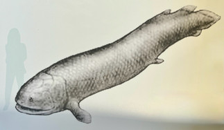


Rendition of “The Walking Fish” - Fossilized tracks @ Alexander Falls - Fossilized track
The museum also has a local artist feature wall. Right now on display are artworks by Chris Robson. Although Chris was not from NWT, he did move there in 1981 and spent much time drawing and painting local historical scenes in communities in the North including Hay River. A few of his pieces on display show the original town of Hay River prior to the 1963 flood.


Artwork by Chris Robson
Also at the museum, there are taxidermy of animals found locally around Hay River which include of course a bison, owls, ptarmigans (one of the few birds to have feathers on their toes to help them walk on snow), northern flickers, and a bald eagle, which I thought was huge only to find out it was young and they normally grow to be twice that size. Guy knew right away it was not an adult since to the top of its head was not completely white, as an adult eagles would have.


Owl - Ptarmigans - Bald Eagle
Another interesting thing here was a display of Fish Scale Art. This is a Indigenous art form usually created within the Métis and Cree communities in Northern Alberta as well as in the NWT and Yukon. The artists take the scales of whitefish and using different natural dyes colour the scales and make and create beautiful designs. There were a few beautiful Fish Scale floral jewelry pieces on display here and the centre of the flowers were made from the vertebra of the fish. I just found it so fascinating the amount of time and patience that goes into these art creations. On Saturday before we left Hay River we went to the local Farmer’s Market which is held every Saturday here and we did purchase a beautiful Fish Scale Art piece from the artist whose pieces were displayed in the museum. We chatted with the lady for awhile and she explained her art process. This small piece will be a wonderful memory to take home with us to Calgary.


Fish scale Art in the Hay River Museum & the piece we purchased
Outside the museum there were displays of different old vehicles used in the area throughout the years like Hay Rivers first Fire Truck. Now there’s a bit of a funny story with this. Back in 1954 Fire Chief Emil Eyford (Hay Rivers first fire chief) along with two other men went to Edmonton to pickup the brand new Mercury Fire Truck - a Dodge. On the way back home to Hay River the siren on the fire truck would periodically turn on. After quite a few stops and attempts to try to figure out why, they discovered that the siren was being activated by a switch on the floor on the passenger side which one of the passengers unknowingly had been activating with his foot.
There were also two Bombardier, “Snow Bugs”, on display. These were invented by Joseph-Armand Bombardier, from Valcourt Quebec before his well known invention the “Ski-Doo”. They were used for transporting children to school, fishing expeditions, or taking workers into working camps. They were popular for their enclosed cabin and ability to travel through deep snow. There was also a Freight Sled which was used for hauling ice blocks, wood, and fishing gear. These were usually towed behind dogs, Snow Bugs, or snowmobiles across the frozen lakes and rivers.


Hay River’s first fire truck -Bombardier Snow Bug - Freight Sled
There was a teepee here as well which was more of a modern style rendition made from canvas. We could walk inside and it certainly gave you the sense of how large these living spaces really were. Traditionally teepees were made of animal skins and wooden poles. They are very durable and provide warmth and shelter in the winter. They stay cool in the summers and dry in the rain. They can be set up and taken down quickly and were used by nomadic tribes of the First Nations.


Teepee - Hay River Museum


Hay River Museum
For those who are interested, a quick stop at the grocery store was quite a shocker. Red peppers were $14.89 kg, bananas were $3.79 per kg, yogurt was $10.89 for a one litre container, and a packet of oatmeal cookies were $8.89. Needless to say we are not eating peppers, bananas, or cookies for a while. Gas sells at up to $1.70 per litre, which is not as outrageous when compared to other places we have been.
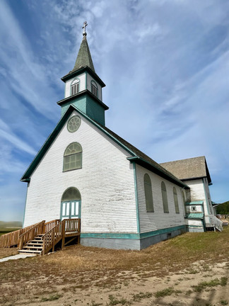
We drove just outside Hay River to the First Nation Hay River Dene Reserve to visit the Historical Hay River Missions Site. This site was first established in 1868. St-Peter’s Anglican Church was here from 1901 to 1909 and at one time also included a large residential school with students from different areas. Ste-Anne’s the Roman Catholic Church was present here from 1938 to 1940. There is a Commemoration Statement outlined on a panel with an apology and acknowledging the pain and loss that has been endured here. There is also a small overgrown cemetery with Spirit Houses - these are burial makers that are thought to have originated from the Cree.


Historical Hay River Missions Site
We made our way to Fort Resolution which is the oldest continuously occupied modern settlement in the NWT. The town was originally located at the mouth of Slave River and in 1796 is was relocated to where it is today. The first settlers here were the Cree-Métis and at one time served as a significant fur trade post. In 1852, the Oblate priests established a mission and school here. These priests lived according to the spirit of the Rule of St. Benedict and of the particular monastery they were affiliated with. These priests made a “promise” of their priesthood, usually renewable every year, to the abbot or superior of the monastery. In 1900 the Treaty 8 with the Chipewyan was signed here and up until the 1950’s this was a major medical and educational center. When we arrived here there was not much opened but we did wander around a bit and were able to fill up Roadie with some fairly inexpensive gas at $1.36 litre.


Fort Resolution
On our way to Fort Resolution we made a stop at Pine Point. This has an interesting story, all that is left here now are paved roadways, sidewalks, and power poles. The town was founded in 1963 and was built to service the Pine Point Mine. The town was built as a collaboration between the mining company Cominco and the Canadian Government. This town at the time was considered one of the biggest mining towns in the north. By the 1970’s Pine Point had reached a population of just over 2,000. There were two schools, four churches, a 30 room hotel, large supermarket, and even a golf course. The mine shut down in 1988 due to the decreased values of lead and basically so did the town. Within a two year period every house and building, which were mobile type structures, were sold and relocated to other areas such as Hay River, Fort Resolution (which now has the hockey arena), and some other parts of Northern Alberta. We drove down a few of the streets but they have now become overgrown with bush and weeds. From the number and size of streets and roadways, the size of the town was actually quite large.


All that’s left of Pine Point
After briefly visiting Fort Resolution, we arrived at our next campsite Little Buffalo River Crossing. Here again we were overtaken by horseflies. But still, as it seems, horseflies are only interested in the van. At six feet away from the Roadtrek, there are virtually no bugs. From our chairs set up outside, we watched as local birds called Common Grackles lined up around our roadtrek eating the enormous amount of buzzing horseflies; these birds have become our new best friends. There was also a group of seagulls searching the grounds for the leftover bones and pieces of discarded fish from the fishermen’s last catch. The sounds these seagulls make is almost human like, screams and screeches and they fly so close we can see their wing patterns and feet. There is an area here for the fishermen to clean their catch of the day and a bucket to throw in the fish heads, guts etc. Now this is a bit of a conundrum, these buckets are just left out in the open. Everywhere else in the NWT we are told to keep our campsites clean, not to leave out any food etcetera that could attract bears. Signs say a “fed bear is a dead bear”. Even on locked garbage containers there are signs that say “absolutely no fish guts”. This bucket full of fish heads and guts surely is a bear attraction, but what do we know, so we go with the flow and keep our bear spray close at hand every time we go to the bathroom as the bucket happens to be on the pathway to the bathrooms. This small campsite is actually more of a fishing base. The site is located along Buffalo River which gives access to Great Slave Lake so it’s makes it an ideal spot for fishermen to camp and launch their boats directly from their campsite, usually twice a day, to go fishing down the river to the lake. The campers walk around in camouflage and waders and the horseflies do not seem too bother them at all, these are real outdoorsy men and women here. We met two guys here from Alaska and they generously shared their catch of walleye fish with us to enjoy - what a delicious treat that was. This campground is more wilderness than we have seen in a while and we suspect that most of NWT will be much the same.


Little Buffalo River Crossing Campground


The bucket , the fish heads and guts
Fort Smith and Wood Buffalo National Park is our next stop. Interestingly enough the majority of this park, 72% of it, is located in Alberta. This park can only be accessed in the summer through the NWT from the Fort Smith area. Otherwise, there is a winter road north from Fort Chipewyan in Alberta. We travelled for 280 kms along the number 5 highway towards Fort Smith and lucky for us we spotted a herd of Wood Buffalo on the side of the road. We were able to stop and enjoy watching in awe at these magnificent creatures so close to us being so natural


Our first views of the bison
An interesting fact about Wood Buffalo National Park is that the World’s Largest Beaver Dam is located just inside the park’s southern border. The dam is about a half-mile long and in the shape of an arc made of connected arcs. In 2007, Jean Thie, a Dutch-born landscape ecologist who lives near Ottawa, was looking at the latest satellite imagery of places he had examined via satellite in 1973 and 1974, while he had been studying permafrost. Back in the early 70’s some scientists thought the Earth might be cooling, and Thie’s research had showed evidence of the opposite. Thie’s paper about permafrost melting, was published in 1974, and is now considered one of the pioneering studies of climate change. He looked over the 1970s images taken by NASA’s Landsat satellite and compared them with the latest images from Google Earth and other sources, he noticed that in certain landscapes the evidence of beavers were everywhere. Beavers had almost been wiped out by the fur trade between the 1600 and the 20th century, but the beavers have now made a comeback. Among the hundreds of beaver dams in this area he came across one that looked bigger. He measured it and found it to be 2,790 feet long. To date, no bigger beaver dam has been discovered, so this is still known as the biggest. The only way to see the dam is by airplane so we obviously did not see it but we thought it a very interesting story nonetheless.


Aerial images of World’s largest Beaver Dam in Wood Buffalo National Park
We arrived in Fort Smith and headed to the Tourist information. A young man named Austin (who is originally from Lethbridge and a huge Calgary Stampeders fan) took us on a walking tour of the town, which took all of 45 minutes, not too long, as the population of Fort Smith is just over 2,200 people. On the tour with us was another very nice couple from Ontario. Austin, who kept reading information from his clipboard finally told us that this was his first tour and that he had only started working at the Visitor Information centre in May. He use to work as a prison guard at the local prison but they closed due to “not enough business”, he said. As we walked around town we were greeted with the all too familiar abundance of blackflies and horseflies. Poor Austin kept wanting us to stop and take a seat on a park bench while he got his papers in order but all four of us kept saying no! no!, as we swatted our arms continuously. Austin says he is now use to the flies and they no longer bother him. How do you get used to hundreds of nagging flies continually buzzing around your head? We certainly did not. Austin did share an interesting fact that Mark Carney, our new Canadian Prime Minister, was born in Fort Smith and moved from here to Edmonton at age 6 years old. Mark Carney’s father was a school principle at the Joseph Burr Tyrrell Indian Day School in Fort Smith.


Tour of Fort Smith NWT
After the town tour we went with Austin for the 1km hike down to the Rapids of the Drowned to see the Pelicans fishing. The trail was a bit mucky and very mosquito infested but definitely worth it - we wore mosquito nets over our heads and that helped some.


These rapids along with three others (Pelican Rapids, Cassette Rapids, and Mountian Portage Rapids) are in the area. They are part of the water system that includes the Slave River which flows to the Great Slave Lake which then flows into the Mackenzie River which eventually flows to the Arctic Ocean - Austin really enjoyed repeating this to us a few times. Seeing the pelicans was beautiful. They sat on the rocks at the edge of the rapids ready to pluck any fish swimming by, it was interesting to observe them.


Rapids of the Drowned & the Pelicans
Our campsite here was at the Queen Elizabeth Territorial Park which again has huge, beautiful, well treed sites. There was only about 4 other campers here so it was quiet and peaceful. This campground is fairly large with 34 sites so we felt again like we were in the middle of nowhere in bear territory.


Queen Elizabeth Territorial Campground


Mosquito repellents and bug tents - sometimes we must protect ourselves from the bugs!
We decided to do a drive to Pine Lake in the Wood Buffalo National Park to so see if we could see any herds of the Wood Buffalo. The Drive from our campsite is just over 70 kms one way. And to Guy’s dismay, the majority of this drive is on gravel road. Gravel road aside, the drive turned out to be beautiful. To top it all off, on our way back, we saw a massive male Wood Buffalo cross our path. He sauntered onto the the road in front of us then slowly took his time to cross. Once on the other side he made his way to a small pool of water and took a few sips. He then decided to forcefully roll himself in the dusty dirt a few times and then he was off up the hill. Bisons roll in the dirt to cover themselves with dust for a protection against the pestering flies. All along the highways there are patches of bare dirt where the bisons do their rolls. We called these “dust bowls”. These dust bowls as well as bison “patties”, often on the road, are sure signs that there are bisons in the area.
Now there is a funny story to our day as well. While we had stopped at Pine Lake I took Treme out for a potty break. Walking along a trail I heard some rustling in the nearby bush and when I looked up to investigate I saw a black bear. Yikes!!! Now I did exactly everything wrong: I yelled, I screamed, I panicked, I ran. And of course our trusty container of bear spray we had purchased was securely sitting inside Roadie. I jumped in the van with Treme and Guy says after he heard me scream he looked out and saw the poor terrified bear running away in the opposite direction with its tail between its legs.


Gravel roads & bison


Buffalo “dust bowls”


Pine lake the scene of Treme and my “bear encounter”
The other stop for us in the Wood Buffalo National Park was a drive to Canada’s only Salt Plains, along a much shorter dirt road this time. At the end of the road there is a small hike down a hill to the plains. The views here were spectacular. Some parts look like old snow banks while other areas were almost pure white. Guy tasted the white stuff and agreed that it really tasted salty. Little did he know that it could have been the remnants of bisons’ urine he just tasted - just saying. Guy tends to have this habit of tasting all sorts of things from plants to who knows what along the way. The plains had beautiful contrast of green plants and purple flowers against the whiteness of the salt. There are cracks in the surface and we could see Wood Buffalo footprints signs that they are around and perhaps use this area as their own private salt lick.


Salt Plains
We traveled to the Lady Evelyn Territorial Park and stayed at yet another wonderful NWT campground. The hike down to the bottom of the Lady Evelyn Falls is 180 steps each way and than a bit of a rocky trail. I am in the habit of counting stairs lately, mostly for curiosity. These falls really are magnificent. They are created by the Kakisa River which starts at Kakisa Lake which is where the smallest town in the Northwest Territories is located. The town, which is named, you guessed it, Kakisa.


Lady Evelyn Territorial Park - Falls - Campground
Just north of Fort Providence, we crossed over The Deh Cho Bridge. This bridge officially opened in 2012 and spans 1.045 km across the Mackenzie River. This bridge took just over four years to construct. It has a single continuous deck running its full length making this the longest joint-less bridge in northern Canada. Before this bridge this road was crossed by ferry in the summer and ice roads in the winter.


The Deh Cho Bridge, Fort Providence & the Mackenzie River, a bit smoky
We traveled through the Mackenzie Bison Sanctuary which was established in 1963 when 18 wood bisons were relocated to this new reserve and were given official protection. These are Canada’s northernmost population of bison and these are the world’s largest free roaming population of wood bison in the world. At one point, disease and hunting had almost wiped them out. In the 1980s there were approximately 2,400 wood buffalo but today there are only around 700. Lucky for us we did get to see a large herd as they grazed along the side of the highway. They even walked onto the road in front of us, blocking us. It seemed they did not have a care in the world.


Mackenzie Bison Sanctuary
Both the Mackenzie Bison Sanctuary and Wood Buffalo National Park are located in the Northwest Territories (NWT), but both have a few differences. The Mackenzie Bison Sanctuary is about 10,000 square kilometres and is located east of Fort Providence. The main focus for this park is on protecting a specific herd of the northernmost population of wood bison which is approximately 700. Whereas the Wood Buffalo National Park is large at 44,741 square kilometres making it Canada’s largest National Park and the 5th largest in the world. It is also an UNESCO World Heritage Site. A smaller portion of the park is located in the southern part of NWT, and the larger portion is in northern Alberta. The Wood Buffalo National Park encompasses boreal forest, wetlands, salt plains, and is the last natural nesting area for the endangered whooping crane, and is home to approximately 3,500 Wood Buffalo.
A hiccup on the road. Our plan at this point was to travel northwards to Yellowknife. But, with only about 150 km left to drive, the smoke from the wildfires made visibility very difficult. It reminded us somewhat of the fog filled roads we had travelled through in Newfoundland. But here the feeling was different, it was an uneasy feeling. This was smoke. At one point we glanced to the side of the road and could see small fires shooting smoke in the air from the ground. At the start of this two year adventure, we promised each other that we would always respect each others gut feelings about the situations we were in. This time we were definitely both onboard; it was time to turn around. What we wanted to see was not worth the possible danger ahead. There are a few wildfires in the Yellowknife area and the thought that this road (which happens to be the only road) might close and we could become stuck did not feel like a good idea. The potential of what we might see or do did not outweigh the risk factor for us. So we both decided it was best to turn around and head back south. Sadly, this meant ending our travels in the NWT.


Smoke on the way to Yellowknife
As we headed back south towards Hay River, it was Saturday, so it seemed like a great idea to once again revisit the local market there to buy some homemade sourdough bread and have the Hay River famous fish & chips for breakfast. That afternoon we drove to the sixtieth parallel and stayed at the last campsite in NWT for the night. This campsite like all others in the NWT did not disappoint. This campsite has seven unserviced sites and we were the only ones there. We enjoyed yet another beautiful and peaceful evening in the territory’s wilderness.


Hay River Market - Sixieth Parallel Campground
Well, Northwest Territories, NWT, you startled us at the beginning with your enormous population of horseflies and black flies who seemed to want to eat us alive. Your wilderness was more vast and filled with solitude than we expected. Your forests are scarred with a generational history of wildfires. But we have, in the end, accepted you, all of you, for what you are. Unbelievably, in the end, we no longer swatted at your pesky flies as much as we desperately did at the beginning. Your territorial campgrounds are by far some of the most beautiful and peaceful that we have yet experienced. Your wildlife is amazing. We saw hundreds of bisons, five black bears, a fox carrying a rabbit in its mouth and birds galore. We were welcomed and felt safe throughout our trip. But unfortunately for us, before reaching our final destination of Yellowknife, our journey was cut short due to the threat of wildfires. Sadly, once again this summer, your people, your wildlife, and your natural beauties must endure more hardships from smoke and wildfires.


Comments